surveyors
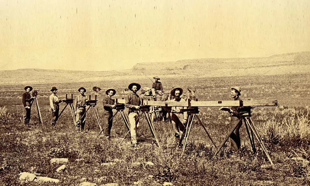 The job of marking out the boundaries of a property, much less an entire nation, while maybe not a complicated job, a big job, nevertheless. The 19th century surveyors were charged with the job of mapping out the entire United States, and to me, that is a huge undertaking. These men were more than just surveyors. These men were the unheralded vanguards of the Old West. They established original geographical boundaries and retraced and identified existing borders in accordance with legal descriptions. It is said that they were part-astronomers, part-geologists, part-engineers, and these mapmakers were also arbitrators when land lines were in dispute. Several wars, and many smaller feuds have been fought and people killed over boundary disputes, and sometimes the surveyor had to be called in to settle the matter.
Some famous men that we all know started out as surveyors. Men like George Washington, Thomas Jefferson, Abraham Lincoln, Meriwether Lewis, William Clark and Daniel Boone When these men were surveyors, actually risked their lives in the line of duty to map what ultimately became the passes, railroads, towns, dams and other structures that helped form the backbone of the West.
Surveyors were the ones who shaped Western history. Their endurance, sense of adventure, and knowledge of precision tools and mathematical principles became the tools of their trade. In fact, they really became Jocks of all trades. While surveying the many miles of the United States, the had to actually blaze trails, so they had to become woodsman, so they could get through some areas to even begin surveying the borders. They became experts in the science of soil management and crop production. As agronomists they worried that hot weather, combined with dry conditions, can hamper pollination. They had to understand the soil and botany. They had to find their food in the wild, because there weren’t any stores in the rugged, wilderness they were mapping.
It was a hard job, and there were many risks, but these men were strong-willed, and determined…and sometimes their lives were on the line. In 1838, came one of the first incidence of a surveyor being killed. It happened just two years after the Battle of San Jacinto…a battle in which the Texians defeated Mexican General Antonio López de Santa Anna. While surveying on the Guadalupe River north of San Antonio, Indians attacked a survey party and killed nine of the crew, including one surveyor who managed to carve his name, “Beatty,” on a tree before he died. At least seven more survey parties were attacked that spring and summer, from the Rio Frio to the Red Sometimes River.
The surveyors were essential when the railroad was being built. The surveyors were the ones who marked out 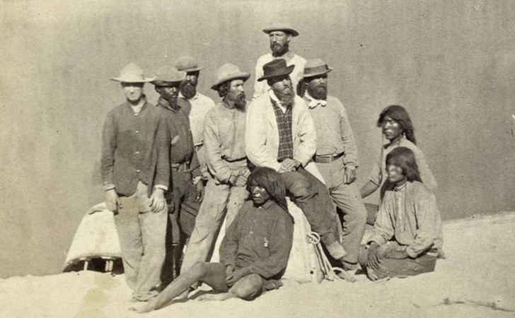 that track lines. They had to make sure they were not overtaking the landowners’ boundaries. The Indians were the main people to fight the surveyors, because they could see more and more of their land being confiscated. What would eventually be good, even for them, was seen as theft to them, and maybe it was, but when we look to the future, it’s easy to see that the land was going be essential to the people of the United States down the road. Nevertheless, the surveyors faced many dangers and really also had to be soldiers, because they were often in a fight for their lives, as they did their work. Surveyors were, and still are, essential to the ever-changing boundry lines in our nation, but that doesn’t make their job an easy one.
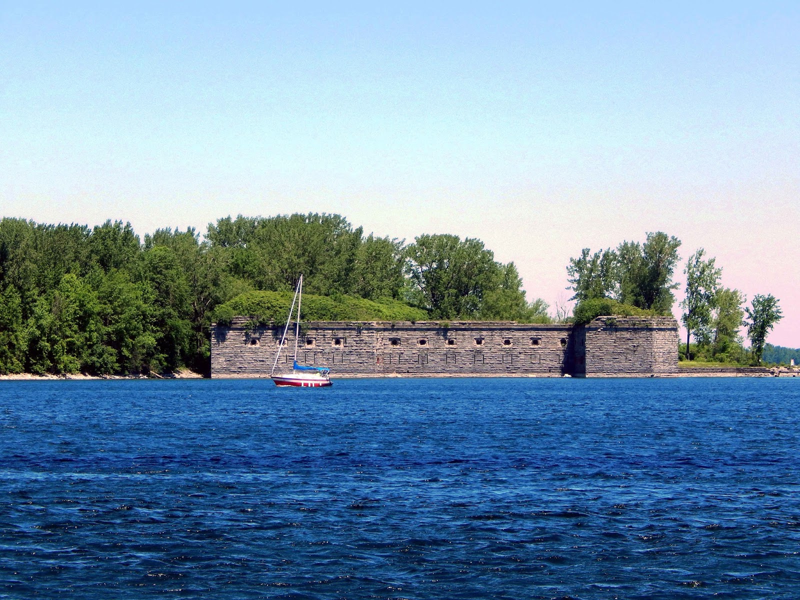 War is a serious matter, but that does not mean that mistakes can’t be made that are really funny when you think about them. After the War of 1812, the United States government was understandably concerned about British ships having access to US borders. The decision was made to built a fort on the border of New York and Canada. It was a good plan that, in the end, had just one flaw.
This plan might have brought into existence, the first American fort, had it not been for one minor detail. The fort was intended to be called Fort Montgomery, and was to be located at the northern end of Lake Champlain. That was all well and good, but there is a moral to the story. “Before you build, make sure your surveyors know what they’re doing.” Construction was begun on the first fort at this location, an octagonal structure with 30 foot high walls, in 1816 to protect against an attack from British Canada such as that which led to the Battle of Plattsburgh in 1814. In July 1817, President James Monroe visited the incomplete fortification and the adjacent military reservation known locally as “the commons.”
This might have been a triumphant visit, however, due to an earlier surveying error it was later found that this first fort was inadvertently built on the Canadian side of the border, resulting in its sometimes being better known as “Fort Blunder.” Of course, that was not its real name, and in fact the fort was never officially named. I suppose the reality is that the United States didn’t have the right to name the fort, because it wasn’t on US land. Nevertheless, the fort was named…unofficially. It became Fort Blunder, because that is exactly what it was. A colossal blunder!!
No one realized the problem with the fort at first. Two years and $275,000 after construction of the fort began, surveyors discovered a problem: The fort was being built on the wrong side of the border. Joseph Totten, later chief engineer of the US Army, supervised construction of the octagonal, 30 foot tall structure. It was to have 125 cannons, and any British ship sailing past would come under heavy fire. Under the Treaty of Paris, the 45th parallel marked the border between New York and Quebec. Therefore, the fort designed to protect the United States from Canada was in…Canada!! All work stopped on the fort, and the heretofore unnamed citadel earned the nickname Fort Blunder.
For the next 20 years, the abandoned fort was subjected to looting. The stones from the fort were taken away 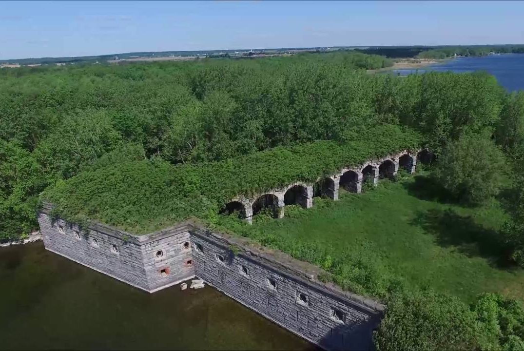 to be used for homes, shops, and meetinghouses. In the end, the United States fixed the location problem not by moving the fort, but by moving the boundary line. In the 1920s, the United States sold Fort Montgomery at auction. In 1983, Victor Podd, a Montreal shipping magnate, bought it. He offered part of the property to New York State for a historic site, but New York didn’t want it. I guess it wouldn’t make sense to make a historical site out of a mistake. After Podd died in 1999, his sons inherited Fort Montgomery. They tried to sell it on eBay and actually got a bid for $5 million, but the deal fell through. The owners still want to sell Fort Montgomery. You can buy it for less than $1 million.
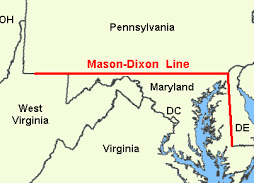
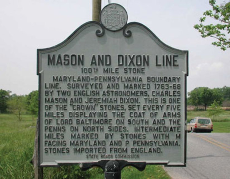
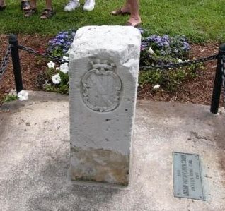 I think most of us have heard of the Mason-Dixon Line, but do we really know what it is and how it came to be called that? Maybe not. It was on October 18, 1767 that two surveyors, Charles Mason and Jeremiah Dixon completed their survey of the boundary between the colonies of Pennsylvania and Maryland, as well as areas that would eventually become the states of Delaware and West Virginia. The Penn and Calvert families had hired Mason and Dixon, two English surveyors, to settle their dispute over the boundary between their two proprietary colonies, Pennsylvania and Maryland. The dispute between the families often resulted in violence between the colonies’ settlers, the British crown demanded that the parties involved hold to an agreement reached in 1732. In 1760, as part of Maryland and Pennsylvania’s adherence to this royal command, Mason and Dixon were asked to determine the exact whereabouts of the boundary between the two colonies. Though both colonies claimed the area between the 39th and 40th parallel, what is now referred to as the Mason-Dixon line finally settled the boundary at a northern latitude of 39 degrees and 43 minutes. The line was marked using stones, with Pennsylvania’s crest on one side and Maryland’s on the other.
When Mason and Dixon began their endeavor in 1763, colonists were protesting the Proclamation of 1763, which was intended to prevent colonists from settling beyond the Appalachians and angering Native Americans. In reality, expansion was inevitable, but many in government couldn’t seem to see that. As the Mason and Dixon concluded their survey in 1767, the colonies were engaged in a dispute with the Parliament over the Townshend Acts, which were designed to raise revenue for the British empire by taxing common imports including tea. A protest that resulted in the Boston Tea Party, but that is another story. Twenty years later, in late 1700s, the states south of the Mason-Dixon line would begin arguing for the perpetuation of slavery in the new United States while those north of line hoped to phase out the ownership of human property. This period, which historians consider the era of “The New Republic,” drew to a close with the Missouri Compromise of 1820, which accepted the states south of the line as slave-holding and those north of the line as free. The compromise, along with those that followed it, eventually failed, and slavery was forbidden with the Emancipation Proclamation in 1862.
One hundred years after Mason and Dixon began their effort to chart the boundary, soldiers from opposite 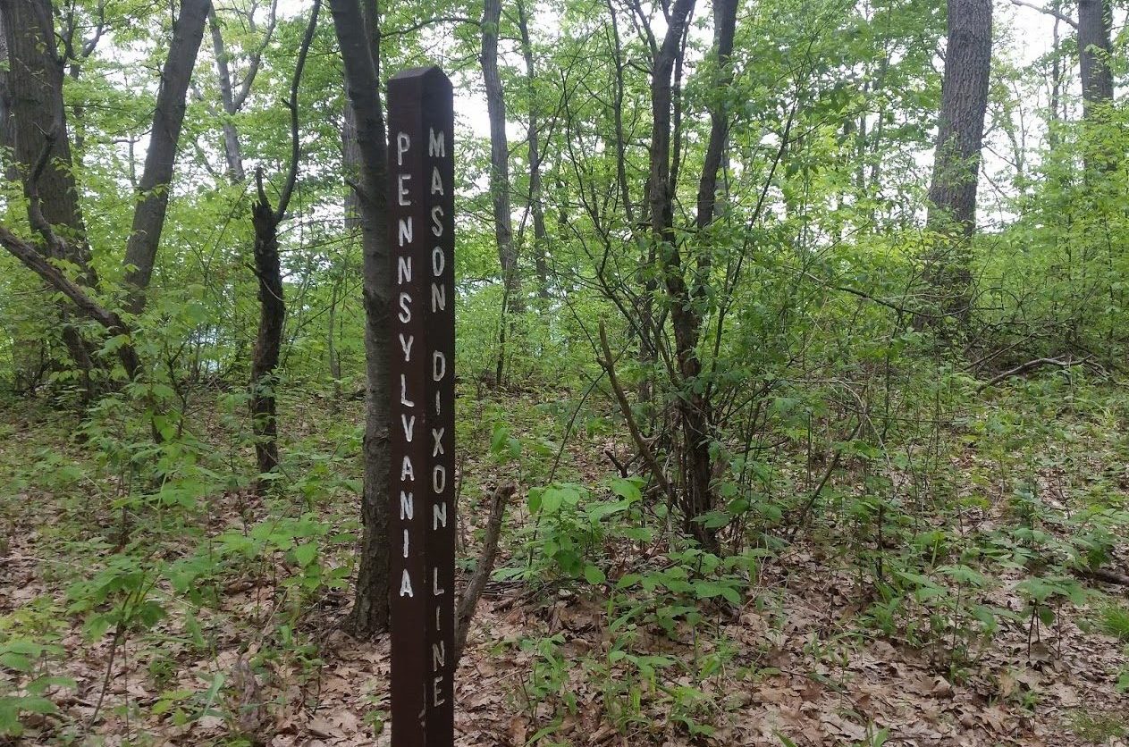
 sides of the line spilled their blood on the fields of Gettysburg, Pennsylvania, in the Souths final and fatal attempt to breach the Mason-Dixon line during the Civil War. One hundred and one years after the Mason and Dixon completed their line, the United States finally admitted men of any complexion born within the nation to the rights of citizenship with the ratification of the 14th Amendment…a poorly thought out amendment which continues to cause illegal immigration to this day, due to birth right citizenship.
 Over the centuries, metals or the discovery of metals have been something that has created everything from excitement to violence. Probably the best known discovery was that of gold, and while it is very valuable, there are many other very important metals, like iron, for instance. Very seldom do we think about all the things that are made with iron, and what an inexpensive, yet versatile metal it is. Iron is one of the most abundant metals found on earth, making up close to five percent of its crust. These iron minerals are typically mixed with clay, sand, rock or gravel. Iron is so common that it may be found in your backyard. Nevertheless, it is only mined commercially when the concentration is large enough to make it worth going after. Iron is used in cookware, fencing, vehicles, motors, buildings, and steel, just to name a few. And, every American born will need 27,416 pounds of iron in their lifetime.
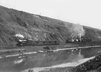
On this day September 5, 1844, iron ore was discovered in Minnesota’s Mesabi Range. The discovery was made 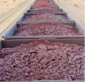 while the miners were on their way to prospect for gold. Because gold was the metal everyone was excited about, the iron ore was virtually ignored. As metals go, the iron would become far more valuable in northern Minnesota than gold. In fact, for the past 50 years, Lake Superior iron ore accounts for 90% of United States iron ore production, with much of that ore coming from the Mesabi Range, where that first discovery occurred back in 1844. Iron ore makes up the majority of Lake Superior shipping, and would soon become the most lucrative occupation in the Lake Superior shipping industry. Just imagine if you were one of those men who walked away from the iron ore discovery, in search of gold, which most never found. Wouldn’t you be kicking yourself now? There were millions to be made in the iron industry.
Shipping on Lake Superior is dominated by iron ore cargo. Of course, that is not the only thing shipped, but the 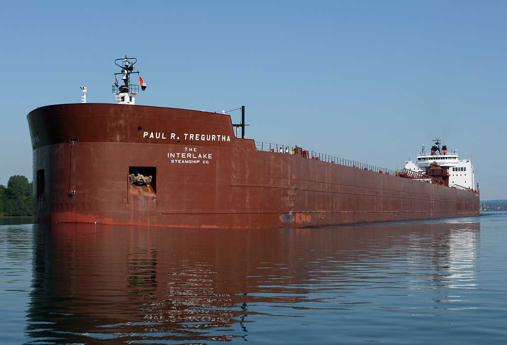 iron ore ships, which are always called ore boats, are among the most amazing in my book. The largest ore boat, the Paul R. Tregurtha is the reigning “Queen of the Lakes” title holder as the longest vessel on the Great Lakes at 1,013 feet 6 inches was constructed in two sections. When my mom, Collene Spencer, my sister, Cheryl Masterson, and I were in Superior three years ago, we got to see this amazing vessel as it left port. Of all the ships on Lake Superior, the ore boats are the ones most people think of when they think of ships on the lake. For people who make their living on the lake, the ore boats are their bread and butter. And to think it all started with a discovery that no one seemed to care about. In the end, it was an unexpected gold mine.

