History
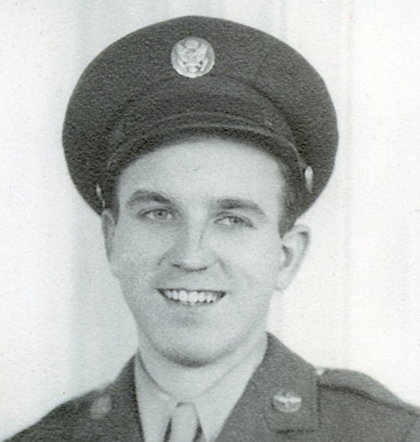
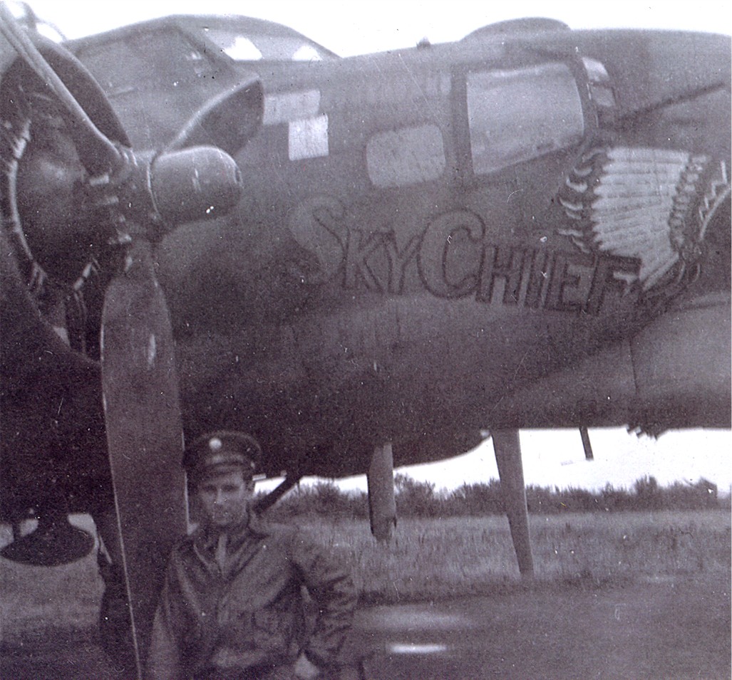 During World War II, my dad, Staff Sergeant Allen L Spencer, was stationed at Great Ashfield, Suffolk, England with the 385th Bomb Group as the Flight Engineer and top turret gunner. While his B-17G Bomber was never given a name, it was customary for the men to fly in different bombers on missions. They were used where they were needed. I don’t know if my dad was ever a crew member on the B-17 Flying Fortress nicknamed Sky Chief (serial 42-39912) or not, but he did have his picture taken by that plane. “Sky Chief” was a B-17G-5-VE bomber with the 385th Bomb Group, 548th Bomb Squadron at RAF Great Ashfield, known as the B-17 Bomber Flying Fortress – The Queen of the Skies. It was delivered to the United States in May 1943, it was ferried to the United Kingdom in October, modified for operational use, and then sent back to the United States for ferrying in November 1943.
When these planes went out on missions, the challenges were often brutal. Flak was notorious for tearing planes apart. Nevertheless, the B-17 wasn’t called the Flying Fortress for nothing. Many times, these planes returned to base practically in pieces, and yet…they quite often returned. On July 16, 1944, “Sky Chief” was returning from just such a mission and attempted to land at RAF Woodbridge (ELG) in Suffolk, England. With engines number 2 and number 4 completely missing, the aircraft faced serious handling challenges. As it neared the runway, it lost control and crash-landed in Capel Saint Andrew, a small village in the English countryside, marking a tragic moment for the B-17 Bomber. The crash was severe, with the B-17 Bomber breaking apart on impact and instantly killing two crew members. The rest of the crew, including pilot Charles R Johnston, co-pilot Frank Bullen, navigator Hubert Bevins, bombardier Charles Wynn, and other gunners, survived but sustained injuries. The aircraft was a total loss, and the survivors were evacuated.
Though considered a total loss, “Sky Chief” was officially salvaged on July 19, 1944. The event served as a 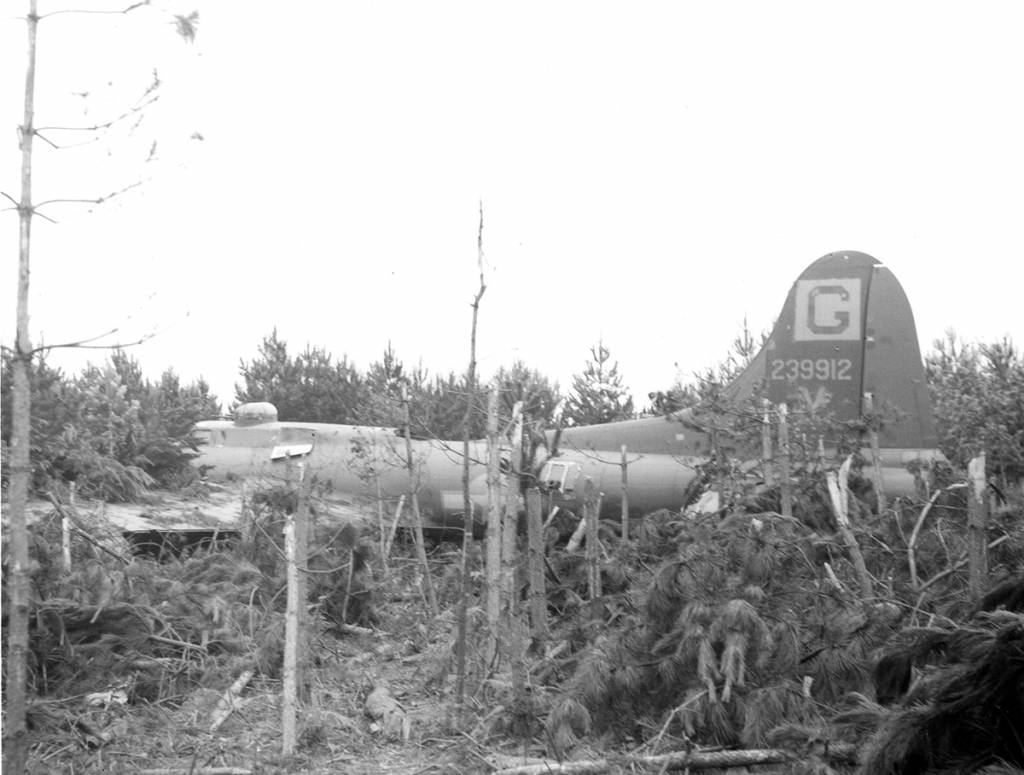 stark reminder of the risks posed by engine failures and poor landing conditions during World War II bombing missions. Its story lives on in aviation history archives, with the nickname “Sky Chief” honoring its service as a veteran bomber in the Eighth Air Force. The 1944 crash happened during the intense preparations for the Battle of the Bulge, as Allied air forces carried out heavy daylight bombing runs over Germany. Incidents like the loss of Sky Chief were all too common, with B-17s battling intense flak, mechanical issues, and the difficulties of night landings at unfamiliar airfields. The story of “Sky Chief” is woven into the larger tale of the B-17’s service and the sacrifices made by its crews. It lives on in my memory because of the pictures with my dad standing next to a plane that I know later crashed. That feels so strange to me.
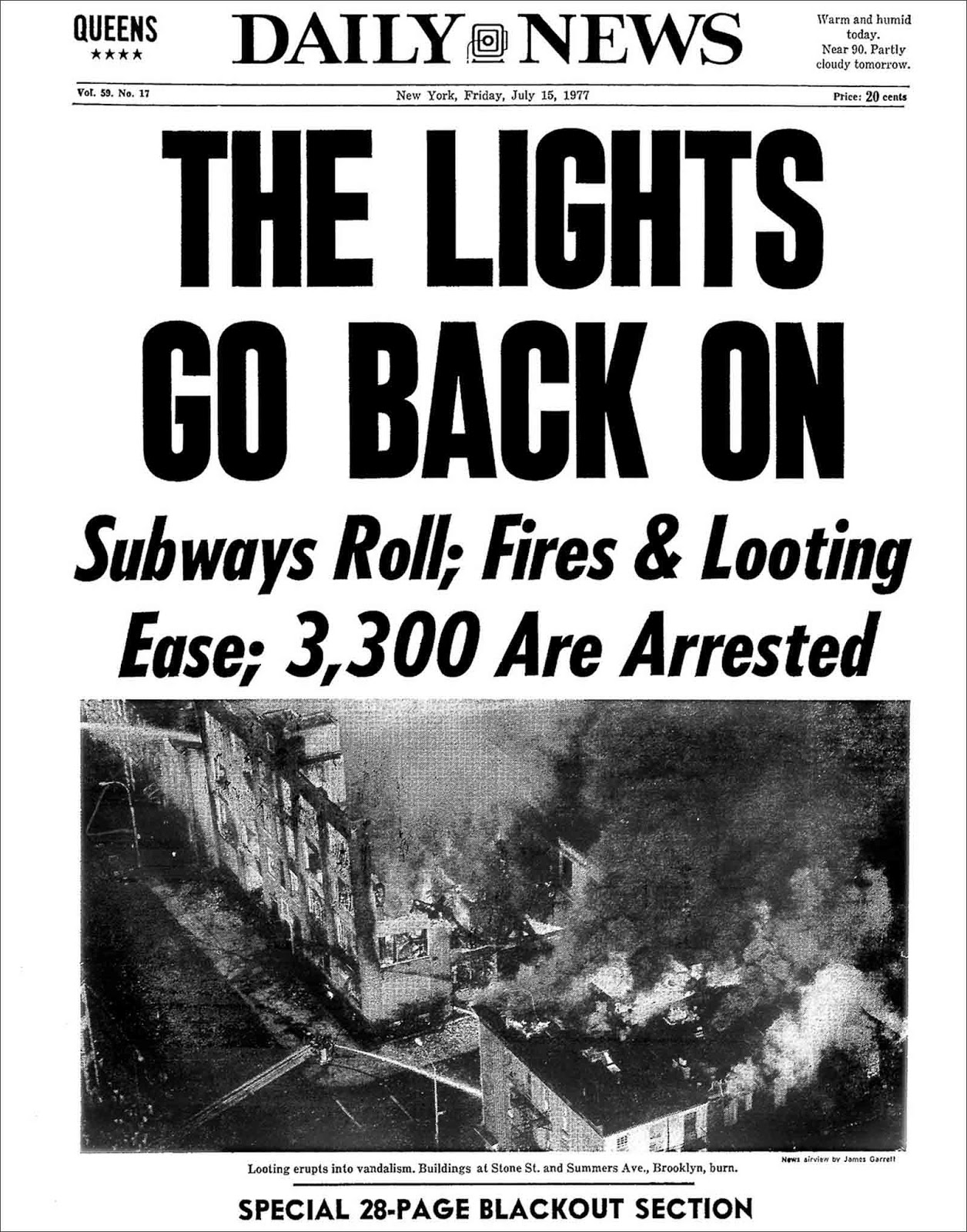
 On the evening of Wednesday, July 13, 1977, at 8:34pm EDT, a lightning strike hit the Buchanan South substation on the Hudson River, tripping two circuit breakers in Buchanan, New York. This substation reduced the 345,000 volts from the 900 MW class Indian Point nuclear generating station to a lower voltage for commercial use. However, a loose locking nut and a slow upgrade cycle kept the breaker from resetting, stopping the power from flowing again. A second lightning strike knocked out two 345 kV transmission lines, with only one coming back online automatically, cutting power from the Indian Point nuclear plant. This pushed two other major lines into overload. At 8:45pm EDT, Consolidated Edison tried to start a fast-response generating station, but the remote start failed since no one was there to run it. Other plants kicked in, though some turbines were down for maintenance and couldn’t provide full capacity.
Then, at 8:55pm EDT, a third lightning strike hit the Sprain Brook substation in Yonkers, knocking out two more key transmission lines. Because the system prioritized the already-isolated Indian Point plant, only the north–south line came back automatically, and poor control-room display design kept operators from noticing at the time. When a second transmission line opened, it left Con Edison disconnected from major generating stations  across the Hudson River. As a result, power was rerouted through cross-river lines in Newark or upstate New York before heading back toward New York City. The remaining lines into the city couldn’t handle the extra load without surpassing their long-term capacity limits.
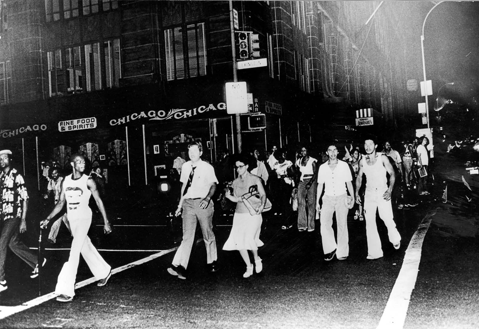
I don’t know why a power outage should have caused the events that followed, but for whatever reason, some people tend to go crazy over things like that. Nevertheless, the blackout had hit during a tough time for the city, with a severe financial crisis and fear from the Son of Sam murders hanging over residents. The whole country, especially New York City, was in a long economic slump, and people compared the event to the lighter mood of the 1965 blackout. Some blamed the city’s money troubles for the chaos, while others pointed to the sweltering July heat wave gripping the East Coast. It didn’t help that the 1977 outage struck after businesses had closed, unlike in 1965 when many shop owners were still around. This time, looters kept going well into the daylight hours of the next day.
Looting and vandalism swept through New York City, affecting 31 neighborhoods. Crown Heights was hit hard, with 75 stores on a five-block stretch looted and damaged, while Bushwick saw rampant arson, leaving about 25 fires still burning the next morning. At one point, two blocks of Broadway in Brooklyn, separating Bushwick 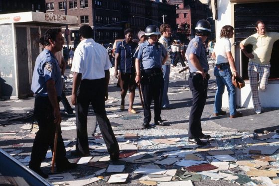
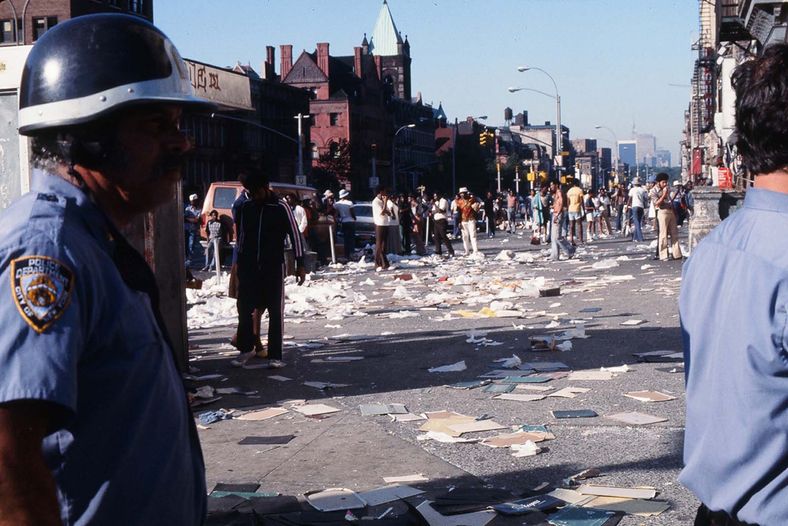 from Bedford-Stuyvesant, were ablaze. In total, 35 blocks of Broadway were destroyed, with 134 stores looted and 45 also set on fire. Thieves made off with 50 new Pontiacs from a Bronx dealership. In Brooklyn, some youths used cars and ropes to pull away store grates before looting inside. The chaos left 550 police officers injured and resulted in 4,500 arrests. It’s such a sad incident.
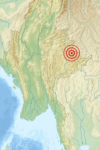 From September 19, 1994, to May 12, 1995, a series of earthquakes with magnitudes of 4.7 MS (surface-wave magnitude) or higher shook the Myanmar-China border area. At the same time, seismologists noticed unusual anomalies in the region’s seismic data, and changes in water levels in Shidian County were seen as possible warnings of a major quake. Then, following the 6.2 ML (local magnitude scale) foreshock on July 10, 1995, the Yunnan Seismological Bureau sent a team to the area nearest the epicenter. After holding a meeting, seismologists predicted that a mainshock of around magnitude 7.0 was likely. Scientists from the Yunnan Provincial Earthquake Administration recommended an evacuation order based on this forecast, and less than 30 hours later, the mainshock hit.
The 1995 Menglian earthquake, also known as the Myanmar–China earthquake, struck on July 12 at 5:46am local time along the border between the two countries. Its epicenter was on the Myanmar side in the mountainous Shan State. Measuring 7.3 on the Chinese surface-wave scale and 6.8 on the moment magnitude scale, it reached a maximum Mercalli intensity of VIII. Because of the early evacuation, the quake only killed 11 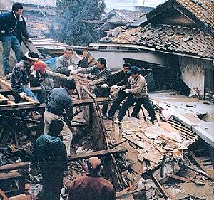 people. It also injured 136 people, however, and destroyed over 100,000 homes in both nations, with another 42,000 seriously damaged. Some structural damage was also reported in Chiang Mai and Chiang Rai, Thailand. The relatively low death toll was credited to an early warning triggered by foreshocks and seismic anomalies, leading to evacuations before the main shock. It is considered one of the rare cases of a successfully predicted earthquake. I suppose that there would be some people who would say that it was luck, and maybe it was, but the seismologists saw something in the situation that caused them to be alarmed. And the scientists agreed and called for the evacuation. Whatever the case may be, lives were saved.
The Shan Plateau, stretching across Yunnan and Shan State, is characterized by strike-slip structures that handle the Sunda Block’s crustal rotation and deformation from the India-Asia collision, where the Indian plate is forced beneath the Eurasian plate. It was shaped by uplift along the Shan Scarp Fault Zone, an inactive shear zone and reverse or thrust fault at its western edge. To the east lies the active Sagaing Fault, a right-lateral transform fault dividing the Burma and Sunda plates. To the north, the Red River Fault extends for 1,000 km as  an active right-lateral fault. Between the Red River and Sagaing faults, bookshelf-style faulting from shear deformation has led to mostly right-lateral strike-slip faulting across the plateau. The earthquake happened due to dextral strike-slip faulting at a shallow depth in the Shan Plateau, rupturing a previously unmapped northwest–southeast striking structure near faults tied to the 1988 Lancang–Gengma earthquakes. Strike-slip faulting here results from “bookshelf-style” deformation caused by the plateau’s position between the Sagaing and Red River faults. The 1995 earthquake may have been triggered by increased coulomb stress transfer from the 1988 event. While the cause may never be fully known, the people whose lives were saved will aways be grateful for the quick actions of the seismologists and scientists who made the call.
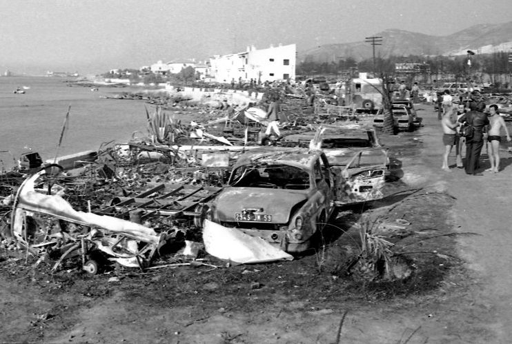
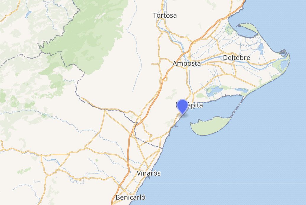 While trying to avoid the meager cost of a toll on the nearby turnpike, on July 11, 1978, a road tanker owned by Cisternas Reunidas was traveling on a small, winding road 120 miles south of Barcelona. I don’t know what the toll would have been for the truck or its cargo, but it couldn’t have been too much when compared to the loss of lives that resulted from the truck being on the smaller road. On that hot afternoon just after 3pm along Spain’s Mediterranean coast, a 38-ton truck loaded with propylene gas, used to make alcohol, made its way down a narrow, winding road about 120 miles south of Barcelona. For reasons still unclear, the truck suddenly slammed into a concrete wall. Some witnesses claimed they saw flames on the vehicle before the crash.
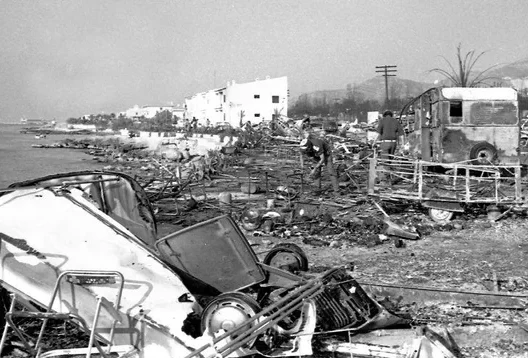
Later called the Los Alfaques disaster the explosion happened near a holiday campsite in Alcanar, Spain. The liquefied propylene was extremely flammable, and the explosion killed 215 people, severely burned 200 more, and took the lives of 178 French nationals. Just down a hill from a concrete wall, about 800 people…mostly vacationing families from Germany and France…were camped near the beach in tents and makeshift bungalows. The truck careened down the hill and erupted into a massive fireball, sending flames 100 feet into the air and killing many instantly. The blast left a crater 20 yards wide, and the heat caused campers’ portable gas tanks and cars to explode as well. Few survivors wore more than bathing suits, leaving many with terrible burns. The timing of the disaster added to the high death toll, coming just after lunch. Many hadn’t yet returned to the nearby beach. The people simply didn’t stand a chance. So many German citizens were affected that German officials arranged an airlift of doctors and equipment from Stuttgart to help with the relief efforts.
The disaster was one of Spain’s deadliest fire-related incidents, second only to the 1977 Tenerife airport tragedy. Survivors recalled the scene as “like napalm.” There was no way of escape. In its aftermath, Spain introduced new regulations requiring dangerous cargo to be transported through populated areas only at night. 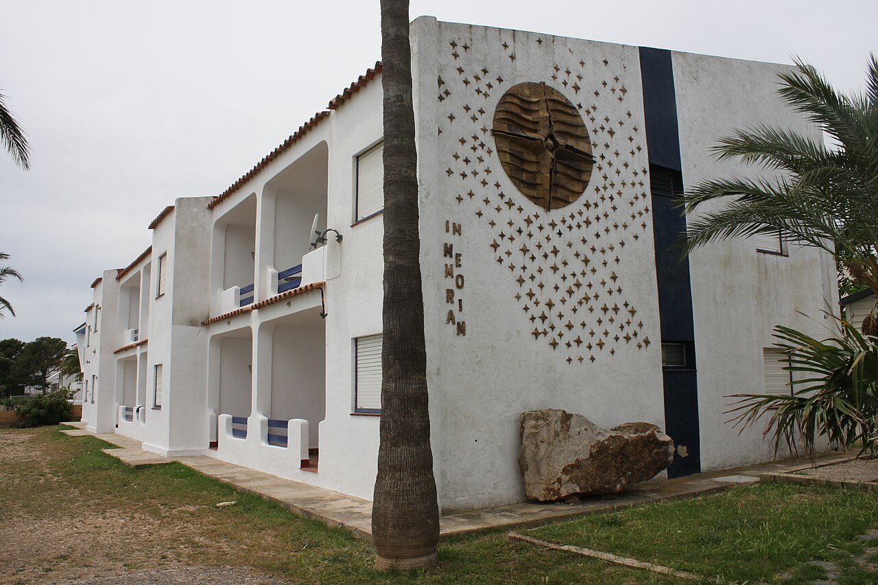
 Several company officials faced prosecution for criminal negligence. Today, the site stands as a memorial to the victims and serves as a sobering reminder of the risks posed by transporting hazardous materials in and around communities. The situation poses a rather tough question. The materials are absolutely necessary in manufacturing needed products, but safety around communities must be a top priority too.
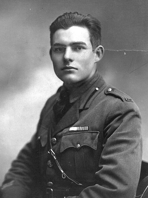 Sometimes, life events can alter the future of the people involved. That was the case with 18-year-old Ernest Hemingway, who was serving as an ambulance driver for the American Red Cross during World War I. Hemmingway was wounded by a mortar shell on the Italian front along the Piave delta during his duties there. Born in Oak Park, Illinois, Hemingway, who had always liked writing, had been a reporter for the Kansas City Star when the war began in 1914. He volunteered for the Red Cross in France before the United States entered the war in April 1917 and was later sent to the Italian front, where he witnessed a series of Italian victories in early July 1918 that saw 3,000 Austrians taken prisoner.
Hemingway’s life would forever change on the night of July 8, 1918. There on Italian soil, Hemingway was hit by an Austrian mortar shell while passing out chocolate to  Italian soldiers in a dugout. The blast knocked him out cold and buried him under dirt, with shell fragments injuring his right foot, knee, thighs, scalp, and hand. While Hemingway survived his injuries, two Italian soldiers standing between him and the point of impact weren’t as fortunate. One of the men died instantly, and the other lost both legs and passed away shortly after. As with most men, Hemingway must have wondered why his life had been spared, when others lost theirs.
Hemingway’s friend Ted Brumbach visited him in the hospital and wrote to his parents about the incident, saying, “A third Italian soldier was badly wounded, and 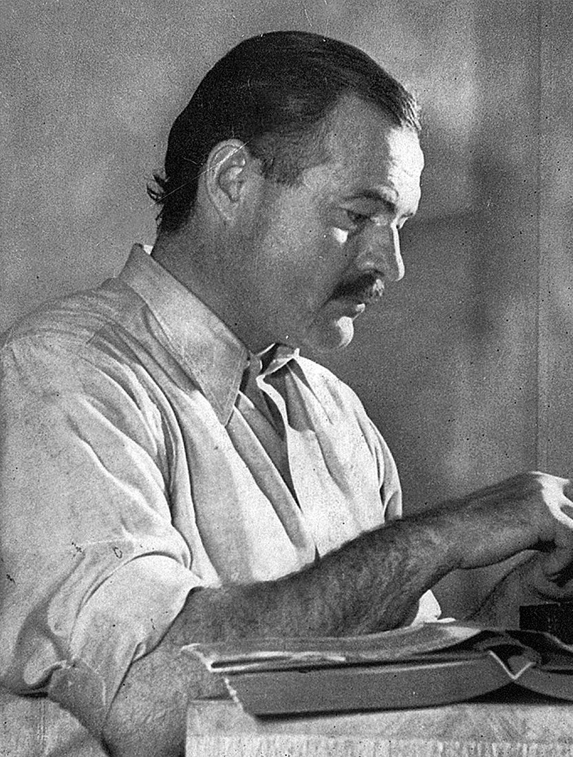 Ernest, after regaining consciousness, carried him on his back to the first aid dugout.” Hemingway didn’t remember how he got there or that he carried the man…until an Italian officer told him the next day, adding that it had been decided to award him a medal for valor. As Brumbach noted, Hemingway received the Croce de Guerra for his service. In his own letter home afterward, Hemingway wrote, “Everything is fine, I’m very comfortable, and one of the best surgeons in Milan is taking care of my wounds.”
As is often the case after a traumatic event, Hemingway’s time in Italy during World War I became a defining part of his “larger-than-life persona” and inspired one of his most beloved novels, A Farewell to Arms. The story follows the romance between a young American ambulance driver and a beautiful English nurse on the Italian front during the Great War. While the novel is fictional, Hemingway wove in elements from his own experiences.
 Today marks a great day in the history of this great nation. We have been an independent nation for 250 years today. That is an incredible accomplishment, and on we should all be proud of. We got started when we fought against British tyranny to gain our independence, and even then, they continued to fight us. Nevertheless, this nation as persevered through it all, and went on to be the great nation it is. Now as we reach our 250th birthday, we can still look back at the years this nation has existed and be proud of all we have accomplished. When this country got started, I doubt if anyone there expected it to last as long as it has…or maybe they did. The founders of this country were visionaries, and so I suppose it is quite likely they would expect longevity, even if they weren’t sure that it was possible. This nation is great because of the greatness of her citizens…and only it’s citizens. We can’t allow illegal aliens to continue to come in and fundamentally change this nation and all the greatness it stands for. I realize that there are people who would disagree with me, and I am not saying that all illegal immigrants are bad, but the minute the cross our border illegally, they become criminals. There is a right way to immigrate and a wrong way, and we must insist on the right way.
Of course, there are also those who would still love to see this country fail, or at the very least, for it to be fundamentally changed into something that wouldn’t even remotely resemble the nation it is today. Nevertheless, I still believe that there are enough of us left in this nation that want to see it flourish that we will fight to keep out socialism and communism…and illegal immigration. These things will not work. This country is great and it must remain great. Socialism, communism, and illegal immigration have all been proven failures, so they will not succeed this time. Those who try, simply won’t succeed.
Today is a wonderful celebration of the success of this Republic. Our Constitution is the best in the world. We  have proven that capitalism is the best way to success for all. I realize that there are those who will disagree with me and that is your right, but if you look at socialism and communism in the past, you will find failure. That cannot be changed. An honest look tells the tale. Illegal immigration only brings in the worst of other nations. The send their criminals to us and keep the good people. We need legal immigration, so we get the best of the best. Our country can remain the great nation it is today, but the rules must be followed. It is the only way that we will continue to succeed as a great nation. And we must stand and insist upon it. Happy 250th birthday to the United States of America…and many more!!
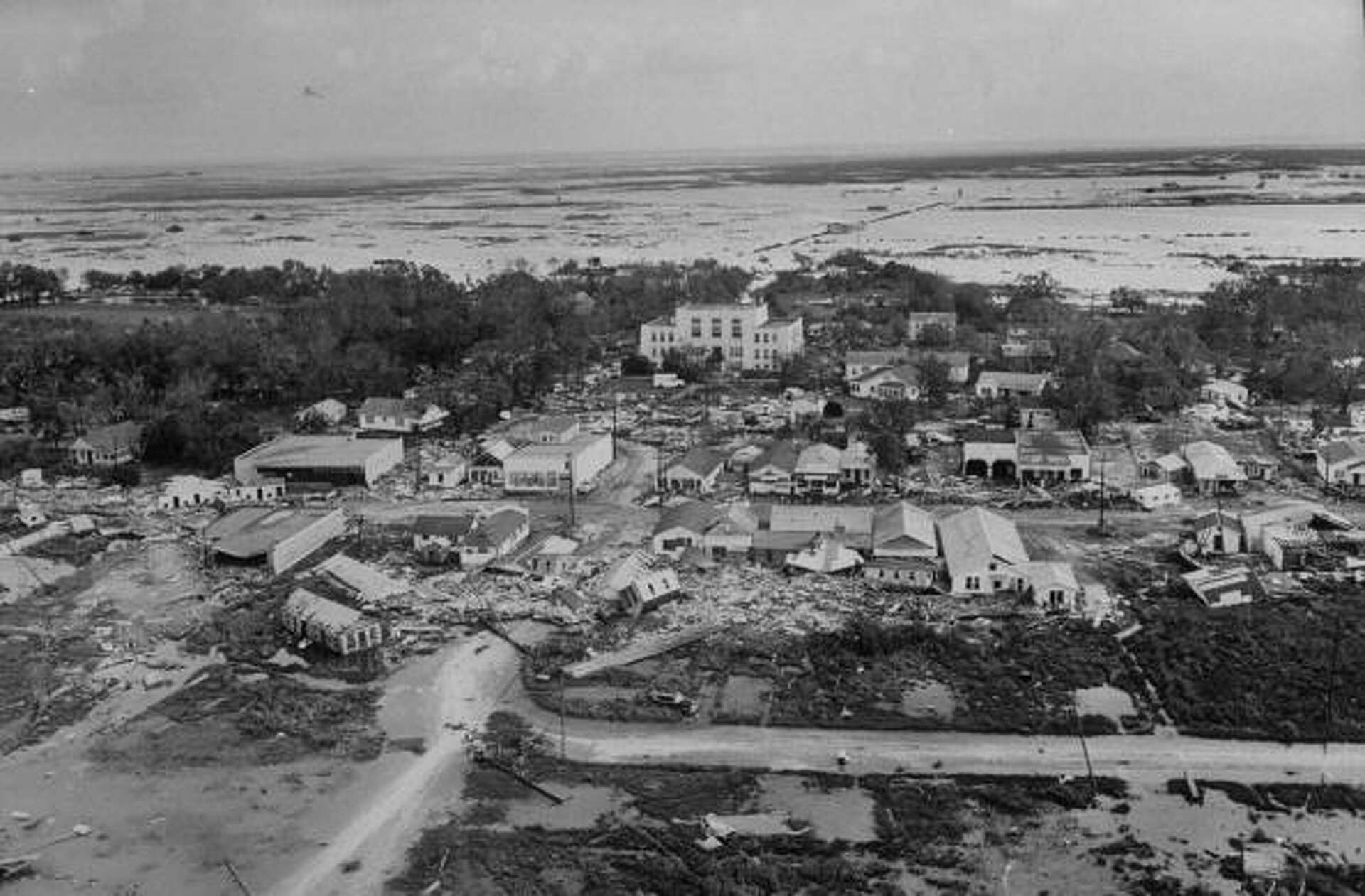
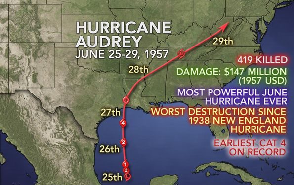 Hurricane Audrey formed on June 24, 1957, from a tropical wave in the Bay of Campeche. It quickly strengthened under perfect conditions, becoming a hurricane by June 25th and went roaring north toward the US Gulf Coast. By June 27th, Audrey hit peak winds of 125 miles per hour and a low central pressure of 946 millibars, ranking among the strongest June hurricanes ever recorded in the Atlantic. The storm made landfall in southwestern Louisiana as a devastating Category 3, causing at least 500 deaths and massive destruction. The hurricane made landfall between Sabine Pass and Johnsons Bayou, Louisiana, holding on to its major hurricane strength before weakening inland and turning extratropical over West Virginia on June 29th. Audrey brought massive destruction along the Texas-Louisiana border, especially in Cameron and Vermilion parishes. A storm surge of 12 to 14 feet swept into coastal Cameron Parish, flooding over 1.6 million acres and carrying homes miles inland. Offshore oil facilities took a $16 million hit, while the region suffered widespread power outages and heavy property damage.
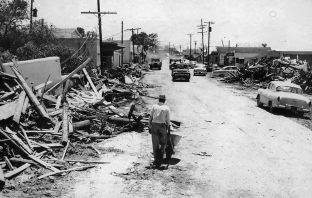
Hurricane Audrey ranks as the sixth deadliest hurricane in US history, claiming at least 500 lives with many others missing, mostly because of the storm surge. Entire towns were wiped out; in Cameron, Louisiana, 60 to 80% of homes and businesses were destroyed, with the courthouse among the few buildings left standing. Its death toll was the highest since the 1938 New England hurricane, a record that stood until Hurricane Katrina hit in 2005. Audrey was the first major hurricane to develop in the Gulf of Mexico since 1945 and the earliest to strike Louisiana. It underscored the risks of rapid intensification and storm surge, shaping future hurricane preparedness and forecasting. Due to its severity, the name Audrey was permanently retired.
 Hurricane Audrey stands out in US hurricane history for its rapid strengthening, unusual early-season arrival, devastating storm surge, and tragic loss of life. It left a lasting mark on coastal communities in southwestern Louisiana and highlighted the critical need for early warnings and strong disaster preparedness. It seems like most disasters bring changes that make future disasters less devastating in one way or another. Some of the best changes to come out of these earlier in history disasters are early warning systems and better building codes. Disasters will come, and storms can’t be stopped, but is people are better prepared, lives can be saved, and that is what is important.
 Yellow fever used to be one of the deadliest of diseases, and it can still be highly dangerous today, with mortality rates depending on how severe the illness becomes. Around 20% to 50% of people with severe yellow fever may die, and about 15% to 20% develop a severe hemorrhagic phase, half of whom don’t survive. For those with severe disease, death rates can range from 30% to 60%. Each year, yellow fever is responsible for roughly 30,000 deaths worldwide, making it a serious threat, especially in regions where it’s common.
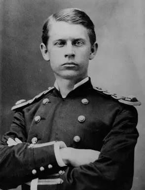
In June 1900, Major Walter Reed, a US Army physician, took command of the United States Army Yellow Fever Commission in Havana, Cuba, tasked with figuring out the cause and transmission of yellow fever. At the time, the disease…spread by virus-carrying mosquitoes…was a serious threat in tropical regions, causing high death rates with no known prevention. Reed was joined by James Carroll, Aristides Agramonte, and Jesse W. Lazear, all experienced in infectious diseases. Their mission was to test 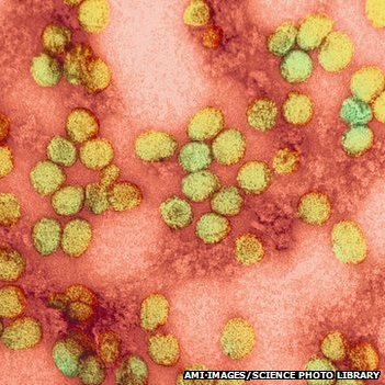 Cuban doctor Carlos Finlay’s theory that yellow fever was spread by the Aedes aegypti mosquito, rather than poor sanitation or direct contact.
Mosquito feeding tests involved hatching eggs from infected patients and feeding the mosquitoes on volunteers, who later recovered, proving the insects could transmit the virus, according to The Army Historical Foundation. In controlled human exposure, volunteers were bitten by infected mosquitoes, offering direct proof of transmission. To disprove other theories, they tested the bacterial theory and miasma hypothesis by having volunteers wear soiled clothing from infected patients, with no cases of transmission observed.
By February 1901, Reed’s team had confirmed that yellow fever was caused by an infectious agent, later  identified as a virus. The female Aedes aegypti mosquito was the only vector, picking up the virus during the first three days of a person’s infection and transmitting it to others through its bite. Reed’s research saved countless lives by enabling targeted mosquito control, inspired public health measures like draining standing water, fumigation, and insecticide use, and helped the Panama Canal project by eliminating yellow fever from construction sites. His work laid the foundation for modern epidemiology and experimental medicine, marking one of the most important medical breakthroughs of the early 20th century.
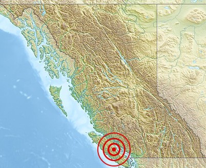 On June 23, 1946, a powerful magnitude 7.3 earthquake struck Vancouver Island, causing significant damage but relatively few casualties thanks to its timing and location. The quake struck at about 10:13a, Pacific Time, and it remains the largest recorded onshore quake in Canadian history. The epicenter was in the Forbidden Plateau area of central Vancouver Island, near Courtenay and Campbell River. Tremors were felt from Portland, Oregon, in the south to Prince Rupert, British Columbia, in the north. The shaking sparked widespread panic, sending people rushing into the streets in cities like Victoria and Vancouver.
The earthquake caused major damage, toppling about 75% of the chimneys in nearby towns like Cumberland, Union Bay, and Courtenay. Comox, Port 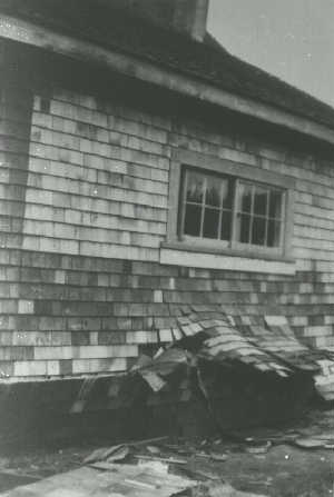 Alberni, and Powell River also saw significant destruction. Sadly, two people lost their lives…one drowned when a small boat capsized in a wave triggered by the quake, and another suffered a fatal heart attack in Seattle. The quake is thought to have been caused by a strike-slip fault linked to Vancouver Island’s geological features, though the exact tectonic forces remain unclear. The event sparked greater interest in seismology in Canada, leading to the installation of more sensitive seismometers and a systematic study of regional earthquakes.
The earthquake triggered numerous landslides across Vancouver Island and caused land subsidence, especially along the Strait of Georgia’s shorelines. Deep Bay’s seabed sank between 9 feet and 84 feet, according to the Canadian Hydrographic Service, and Read Island experienced a 9.8 feet ground shift. Ships in the area felt jolts like running aground, and undersea power lines were destroyed in Alberni Inlet and near Powell River. Lighthouse keepers reported damage such as shattered windows and broken dishes. A tsunami hit Texada Island’s west coast with two waves…one 6 feet 7 inches high and another 3 feet 3 inches high. The quake also 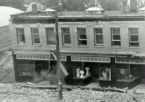 caused a landslide near Mount Colonel Foster. Fortunately, an aerial survey of Vancouver Island began shortly after in 1946, providing valuable photographs later studied in the late 1970s.
The 1946 Vancouver Island earthquake stands out as a major event in Canadian history, reminding us of the region’s seismic activity and the possibility of future quakes. It underscored the need for preparedness and awareness of geological risks in the Cascadian Subduction Zone. This quake marked a key moment in Canada’s seismic history, showing both the force of nature and the resilience of communities facing disaster.
 Since Congress passed the Homestead Act in 1862, land ownership was destined to change drastically. Around 1869, with the Durbin brothers’ sheep ranch near Cheyenne, homesteaders began moving to Wyoming, hoping—like many others in the West, to claim government land for little or nothing and make a living from it. Between 1862 and 1916, seven new laws or changes to the original laws were enacted. Most of the people looking to take advantage of the possibility of owning land were men, because the reality is that homesteading was a tough undertaking, and that meant that it was mostly men that took on the task. Yes, most of them brought their families, but when it came to homesteading alone, men were generally the rule.
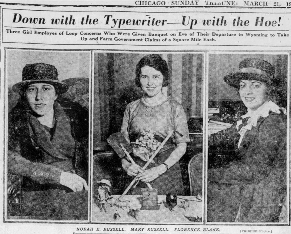
However, there were a few women who decided that the mold of men and homesteading, did not necessarily suit them. One early fall day in downtown Chicago, a woman named Florence Blake met a young male acquaintance who shared his story about claiming land in Wyoming. Blake was instantly inspired to follow suit. Through that conversation, Florence Blake learned about homesteading, and her life would never be the same again. Thanks to a 1912 law that didn’t require year-round residence in order to claim a homestead, she could spend the coldest five months in Chicago, working to fund her venture, and then return to her homestead the rest of the year. Blake decided that if her friend could homestead, so could she. She decided that she was a strong and as tough as he was. It wasn’t really a feminist thing, but rather a determination that if one person was capable, the other could be too. So, Blake worked winters back in Chicago to earn enough to support her claim, which was quickly becoming her passion. Blake worked hard and never gave up until the land was hers.
Strangely, her success was typical. I would have thought that most women who tried homesteading alone, would fail, but research shows that women homesteaders were as likely to succeed as men. Blake’s story soon caught the eye of the Chicago Tribune, and on March 21, 1920, the paper reported that sisters Mary and Norah Russell had also claimed Wyoming homesteads and traveled on the same train as Blake. Blake mentioned them too, though not by name. They reached Gillette during an April snowstorm, and poor road conditions kept Blake in town for about a month, during which she took on various jobs. When the roads cleared, she hired two trucks—one for her portable house and another for a stove and lumber for cupboards, a floor, and an outhouse. The Chicago man who sold her the portable garage-turned-house claimed it “could easily be assembled by a woman,” but in reality, it still took three strong men an entire day to put together the house, a lean-to, and an outhouse. The outhouse had no door but offered a clear view of the nearby Pumpkin Buttes.
Within a few weeks, Blake had settled into her routine. Tending the garden, hauling water from a nearby spring, and trying out various cooking experiments kept her busy. Each evening, she went for a walk: “I’d sit cross-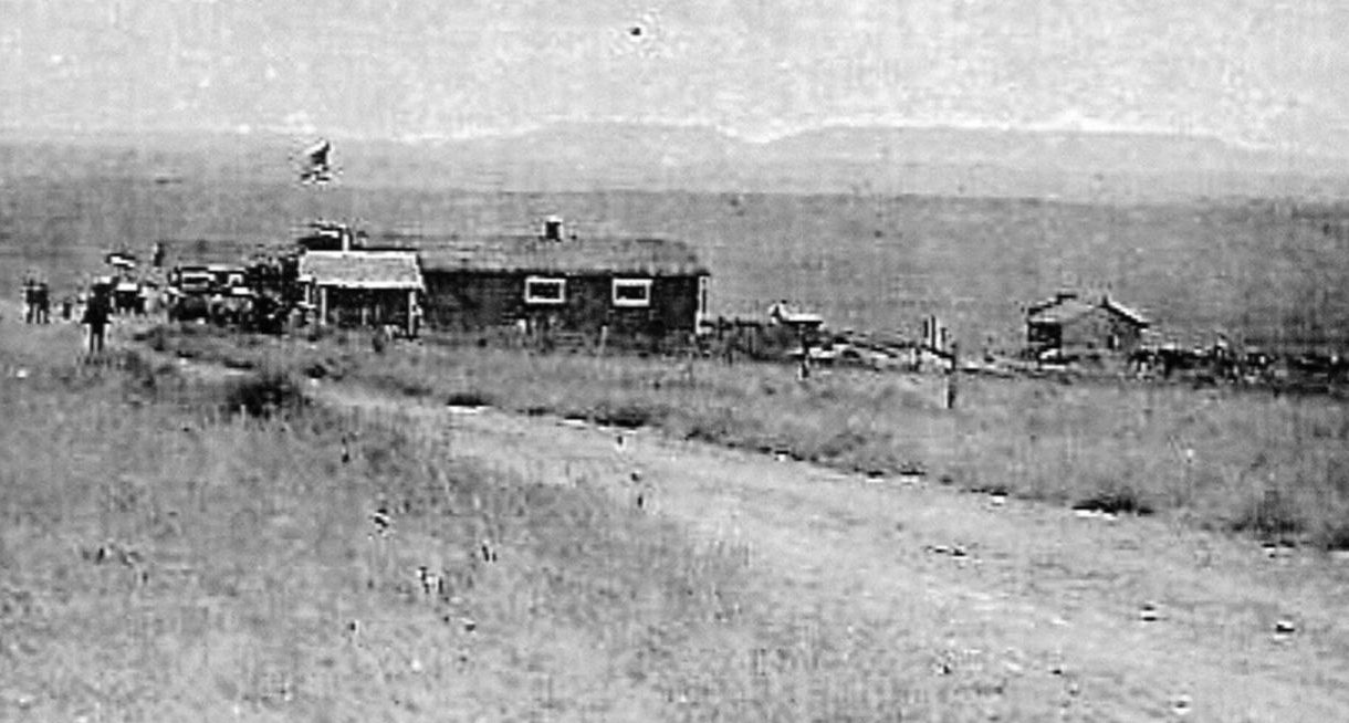 legged on my pet rock, watching the sun set behind the Big Horn Mountains, listening to the many birds settling in for the night. The Meadowlarks sang their last sweet song of the day. The hills were blanketed with wildflowers, and the air was fresh and sweet.” She went on to successfully earn her claim and she stayed in Wyoming, eventually marrying a man named Archibald Smith, a resident of Gillette and former rancher in the area. The couple eventually settled in Cheyenne, where “Arch” had been appointed commissioner in charge of the dairy, foods and oil division for the Wyoming Department of Agriculture.

