eruption
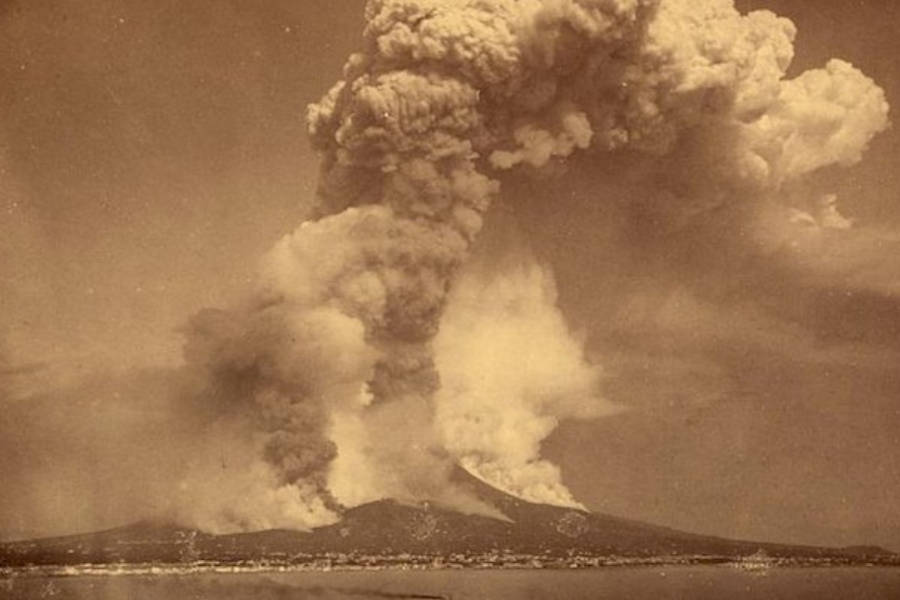 Volcanoes don’t just suddenly start erupting without warning. There is always some kind of warning. Things like earthquake swarms, a bulging mountain side, and little smoke and ash showings from the crater, always come first. These may not always all happen, but they do happen. The biggest problem in 1883 is that scientists didn’t really know that then. When Krakatoa, in the Sunda Strait of Indonesia, began to wake up on May 20, 1883, it had been dormant for around 200 years. The first sign was an ash cloud that was reported by the captain of a German warship. It rose nearly 7 miles above the island. Strangely, no one in Anjer, 25 miles from the island, or Merak, 35 miles away, reported anything unusual that day, but the inhabitants of Batvia, 80 miles away, “were startled by a dull booming noise, followed by a violent rattling of doors and windows. Whether this proceeded from the air or from below was a matter of doubt, for unlike most earthquake shocks the quivering was only vertical.” The event started rumblings and blasts from the volcano’s vents that continued for the next three months. But this was just the beginning.
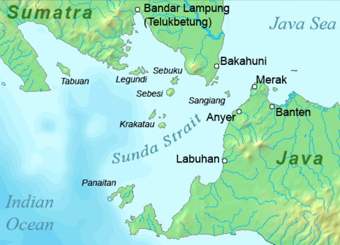
Krakatoa began to erupt in earnest on the afternoon of August 26, 1883, sending ash clouds at 22 miles above the island. Along with the eruption came a tsunami that rolled up both sides of the strait. The eruption continued into the night with increasing violence, and at midnight by volcanic lightning strikes to distances of ten to twelve miles. The event was similar to a horror movie, complete with electrical phenomena to a terrifying scale. The glow that surrounded the gigantic column of smoke and ashes was seen in Batava, eighty miles away. Some of the debris fell as fine ashes in Cheribon, five hundred miles east of the volcano.
While the August 26th event was terrifying, the most terrifying part of the disaster happened the next day. When Krakatoa erupted on August 27, the sound it made was accompanied by pressure waves that ruptured the eardrums of people 40 miles away, traveled around the world four times, and was clearly heard 3,000 miles away. That distance is comparable to the distance between New York and und from San Francisco. The 1883 eruption of Krakatoa was one of the deadliest and most destructive volcanic events in recorded history. Explosions were so violent that they were heard 1,930 miles away in Perth, Western Australia, and 3,000 miles  away in Rodrigues near Mauritius. At least 36,417 deaths were attributed to the eruption and the tsunamis it created. The sound was claimed to be heard in 50 different locations around the world and the sound wave is recorded to have travelled the globe seven times over. Following the eruption, there were increased seismic activity that continued until February 1884, although there is speculation as to whether on not that was because of Krakatoa. Whether it was or not, really makes no difference, because the effects that can be confirmes as part of the aftermath of Krakatoa are big enough on their own. The 1883 eruption of Krakatoa was a major event, and possibly the biggest on in recorded history.
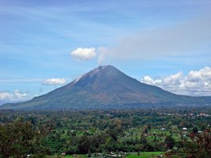 When a volcano hasn’t erupted for 400 years, people naturally assume that the volcano is dead, but volcanos don’t really die, they become dormant. In the case of Mount Sinabung, located on the Indonesian island of Sumatra. On August 29, 2010, Mount Sinabung experienced a minor eruption. The mountain had been rumbling for several days. Ash spewed into the atmosphere up to 0.93 miles high and lava was seen overflowing the crater. The four centuries of quiet were over. The most recent eruption prior to 2010 was in 1600. On August 31, 6,000 of the 30,000 villagers who had been evacuated returned to their homes. As volcanoes go, a category “A” must be monitored frequently, because it is very active. Mount Sinabung was assigned to a category “B,” meaning that no one would really know that more eruptions were on the horizon, unless more rumbling was heard in the days ahead
 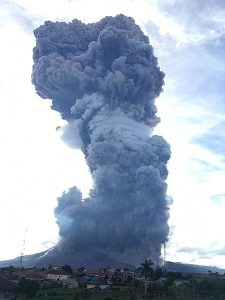 of the eruption. Following the eruption, the Indonesian Red Cross Society and the Health Ministry of Indonesia sent doctors and medicines to the area. The National Disaster Management Agency also provided face masks and food to assist the evacuees.
On Friday, September 3, 2010, two more eruptions occurred. The first one happened at 4:45am, forcing more villagers to leave their houses…some of whom had only returned the day before. This Was the biggest eruption to that date…maybe another reason to start to feel apprehensive. In this eruption, ash spewed up into the atmosphere about 1.9 miles high. In the hours before the eruption, a warning had been issued through the volcanology agency, and most villagers were prepared to leave quickly. A second eruption occurred the same evening, around 6pm. The eruption came with earthquakes which were felt up to 15.5 miles away from the volcano.
Then, on Tuesday September 7, Mount Sinabung erupted yet again…its biggest eruption since it had become active on August 29, 2010. Finally, Mount Sinabung had reached the point of a category “A” listing. Experts warned of more eruptions to come and began monitoring it closely. Indonesia’s chief vulcanologist, Surono, said 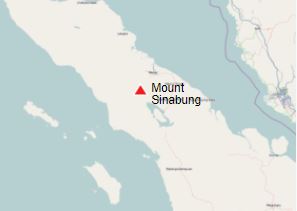 “It was the biggest eruption yet and the sound was heard from 8 kilometers away. The smoke was 5,000 meters in the air.” Heavy rain mixed with the ash to form muddy coatings, a centimeter thick, on buildings and trees. Electricity in one village was cut off, but there were no casualties in that instance. At least 14 people were killed in the early days of the eruptions. Following the reawakening of Mount Sinabung, it has erupted numerous times over the years since, with eruptions every year. It is a highly volatile volcano. The last eruption of Mount Sinabung was on August 10, 2020, producing an eruption column of volcanic materials as high as 16,400 feet into the sky. It doesn’t look like Mount Sinabung will become dormant again anytime soon.
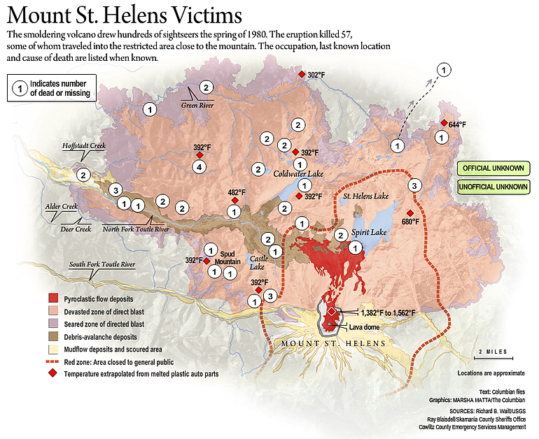
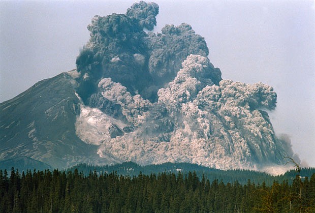 Most people who were alive in 1980, remember the catastrophic eruption of Mount Saint Helens on May 18th, but I wonder how many people…at least people who didn’t live in Washington state at that time…remember the earlier eruption that took place on March 29th. Volcanic eruptions don’t usually bring loss of life these days, because there are so many warning signs. That is what made the 57 lives lost to the Mount Saint Helens blast on May 18th so devastating. The warnings were there. The people were told, but the ones who lost their lives chose to stay in the area anyway, despite the glaring changes in the mountain and the urgent warnings to stay away. We had all heard that there was a distinct possibility that the mountain was going to blow. It was not just the people in Washington who were warned, but all across the nation too. I vividly remember being told what to expect when the mountain blew, because they knew the ash would encircle the entire Earth before it was all said and done.
For a week, prior to March 29th, the area had been hit with small earthquakes below the mountain. These earthquakes were an indication that magma had begun to move below the volcano. On March 20, at 3:45pm Pacific Standard Time, a shallow magnitude 4.2 earthquake centered below the volcano’s north flank, signaled the volcano’s violent return from 123 years of hibernation. Over the 20th and 21st, 174 earthquakes of 2.6 or greater hit the area. At 12:36pm on March 27th, phreatic eruptions (explosions of steam caused by magma 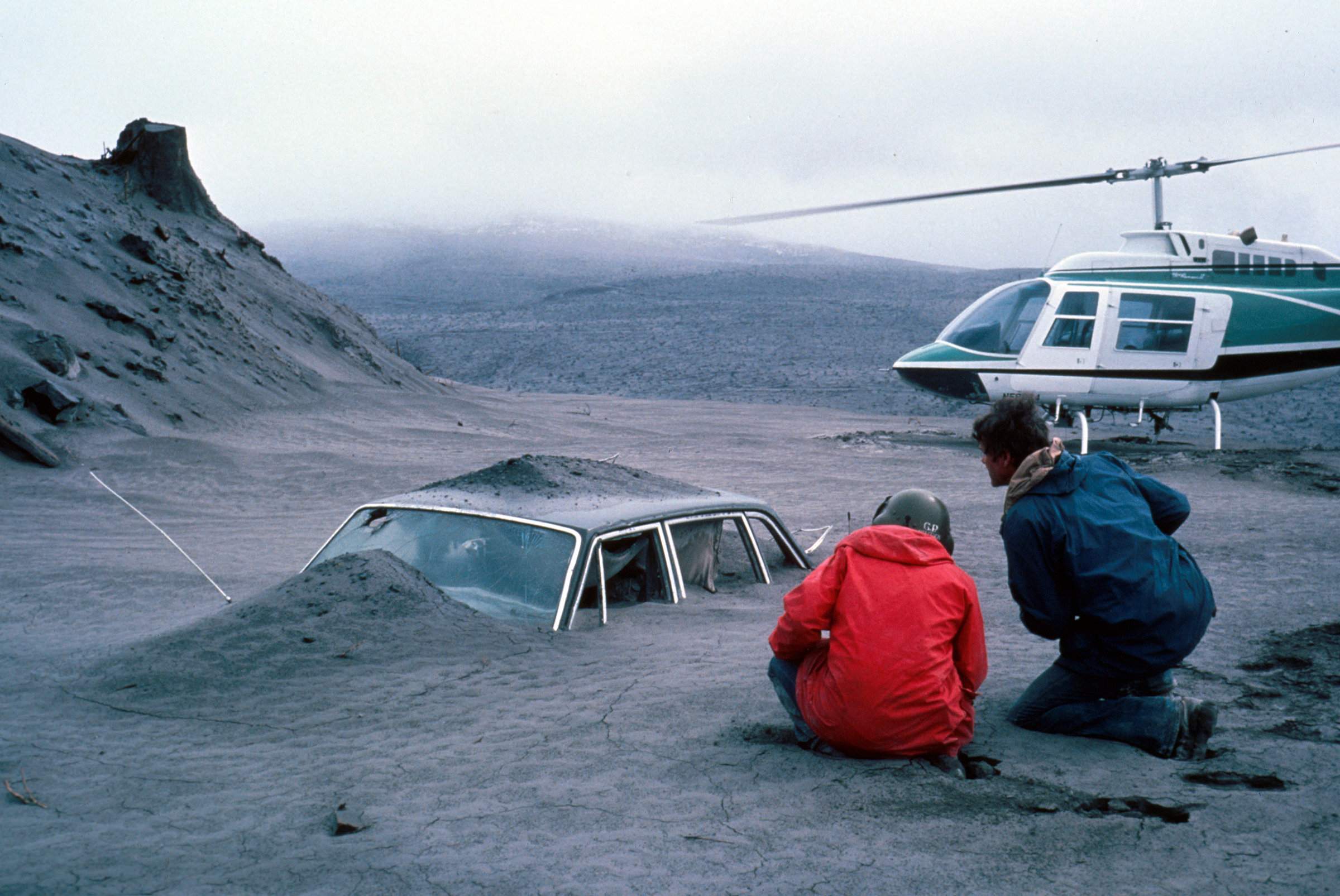
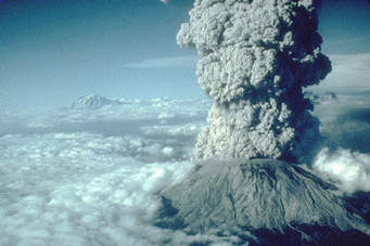 suddenly heating groundwater) ejected and smashed rock from within the old summit crater, opening a new crater 250 feet wide, and sending an ash column about 7,000 feet into the air. On March 29th, an eruption of Mount Saint Helens blasted a mushroom cloud over most of the state of Washington. Then on May 18, 1980, came the catastrophic blast that took the lives of those who had stayed, even with the many warning signs, and public warnings.
I understand the rights of people to make their own decisions concerning their safety, but when warnings are given, the choices people make need to be taken into account before allowing any lawsuits to take place. Of course, as with any kind of disaster, people want someone to blame for the pain they are feeling over the loss of their loved ones. In this case it appears that the safe zone might have been miscalculated, but it is my belief that we are also responsible for our own safety. I remember thinking that I didn’t want to be anywhere near that mountain in those days. Of the 57 people killed, the Weyerhaeuser Company and representatives of 14 victims of the Mount Saint Helens’ 1980 eruption filed lawsuits. The plaintiffs alleged in a King County Superior Court suit that Weyerhaeuser misrepresented the danger posed by the volcano and misled loggers and others into believing it was safe to be near the peak. Maybe they did, but the trial ended in a hung jury. They could not agree either. To me it seems as if this blast was nothing like the normal eruptions people knew about. In the end, the plaintiffs settled out of court for a reported $225,000, but the forest products company still denies 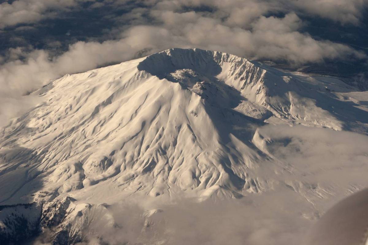
 liability. I don’t claim to know whether or not these 14 victims were wronged or if they simply didn’t take their own safety into account when they went too near the action. I do know that at the time, it made no sense to me to be anywhere near a mountain that was so filled with pressure that it was bulging. I thought that was a warning in itself. I remember the public warnings about the mountain. It simply made no sense to take the chance.
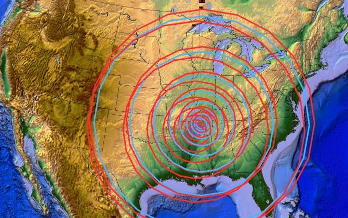 After an earthquake, especially a big quake, you start looking for damage or reports of damage. You will invariably find damage, unless the quake occurred in an area that is completely unsettled or in the ocean. Still, you have to look well beyond the epicenter of the quake…sometimes as far away as 6,000 miles. A big quake can shake things up for many miles. On December 16, 1811 a series of Intraplate earthquakes began, that shook apart the area of the New Madrid fault in present day Missouri, around the Mississippi River. Intraplate earthquakes are often confused with Interplate earthquakes, but are fundamentally different in origin, occurring within a single plate rather than between two tectonic plates on a plate boundary, like the Interplate earthquake does. The specifics of the mechanics by which they occur, as well as the intensity of the stress drop which occurs after the earthquake also differentiate the two types of events. Intraplate earthquakes have, on average, a higher stress drop than that of an Interplate earthquake and generally higher intensity,meaning they can bring more damage. These Intraplate earthquakes continued until February 7, 1812. The first earthquake on December 16th had its epicenter in northeast Arkansas and measured up to an 8 on the Mercalli intensity scale. This earthquake was followed by another six hours later, and two more on January 23rd and February 7th, respectively. The third quake caused warping, magma eruptions, fissuring and landslides. While these were unusual events for the area, the were far from the most unusual events related to this series of quakes.
After the February earthquake, it was reported that the Mississippi River began running backwards, and event that lasted for several hours and caused two temporary waterfalls to develop. The upthrusting of land caused the formation of Reelfoot Lake 15 miles south of the epicenter while the crushing of quartz crystals underground created flashing lights that lit up the sky. Boatmen on flatboats actually survived this experience and lived to tell the tale. Incredibly, the earthquakes could be felt over 50,000 square miles. That is shocking when you think about the fact that the 1906 San Francisco earthquake, which was deadly enough in its own right, was felt over 6,000 square miles.
The New Madrid earthquakes were the biggest earthquakes in American history. While they occurred in the 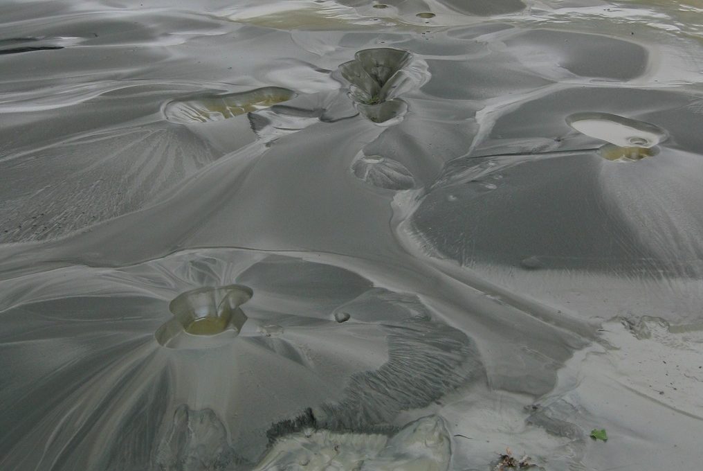 central Mississippi Valley, they were felt as far away as New York City, Boston, Montreal, and Washington D.C. President James Madison and his wife Dolly even felt them in the White House, and church bells rang in Boston. From December 16, 1811 through March of 1812 there were over 2,000 smaller earthquakes in the central Midwest, and between 6,000-10,000 earthquakes in the Bootheel of Missouri where New Madrid is located near the junction of the Ohio and Mississippi Rivers. In the known history of the world, no other earthquakes have lasted so long or produced so much evidence of damage as the New Madrid earthquakes. Three of the earthquakes are on the list of America’s top earthquakes: the first one on December 16, 1811, a magnitude of 8.1 on the Richter scale; the second on January 23, 1812, at 7.8; and the third on February 7, 1812, at as much as 8.8 magnitude.
In addition to the Mississippi River running backwards, there were numerous other strange happenings too. As the area experienced more than 2,000 earthquakes in five months, people learned that most of the crevices opening up during an earthquake ran from north to south, so when the earth began moving, they would chop down trees in an east-west direction and hold on using the tree as a bridge. Unfortunately, there were also “missing people” who were most likely swallowed up by the earth. Some earthquake fissures were as long as five miles. Another strange event, though not totally unusual was the sand boils that formed. A sand boil is sand and water that come out onto the ground surface during an earthquake as a result of liquefaction at shallow depth. The world’s largest sand boil was created by the New Madrid earthquake. It is 1.4 miles long and 136 acres in extent, located in the Bootheel of Missouri, about eight miles west of Hayti, Missouri. Locals call it “The Beach.” Other, much smaller, sand boils were also found throughout the area. Small pellets up to golf ball sized tar balls were found in sand boils and fissures. Known as Seismic Tar Balls, they are petroleum that has been solidified, or “petroliferous nodules.” Lights flashed from the ground, caused by quartz crystals being squeezed. Generally known as Earthquake Lights, the phenomena is scientifically called “seismoluminescence.”
Water thrown up by an earthquake was lukewarm. It is speculated that the shaking caused the water to heat up and/or quartz light heated the water. The skies turned dark during the earthquakes, so dark that lighted lamps didn’t help. The air smelled bad, and it was hard to breathe. It is speculated that it was smog containing 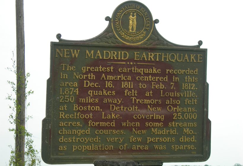 dust particles caused by the eruption of warm water into cold air. Sounds of distant thunder and loud explosions accompanied the earthquakes. People reported strange behavior by animals before the earthquakes. They were nervous and excited. Domestic animals became wild, and wild animals became tame. Snakes came out of the ground from hibernation. Flocks of ducks and geese landed near people. I’m sure that some of these events could be viewed as normal during n earthquake, but certainly some of them or even the mere numbers of these phenomena could be viewed as very strange, and I don’t know that there has ever been a more strange earthquake before or since.
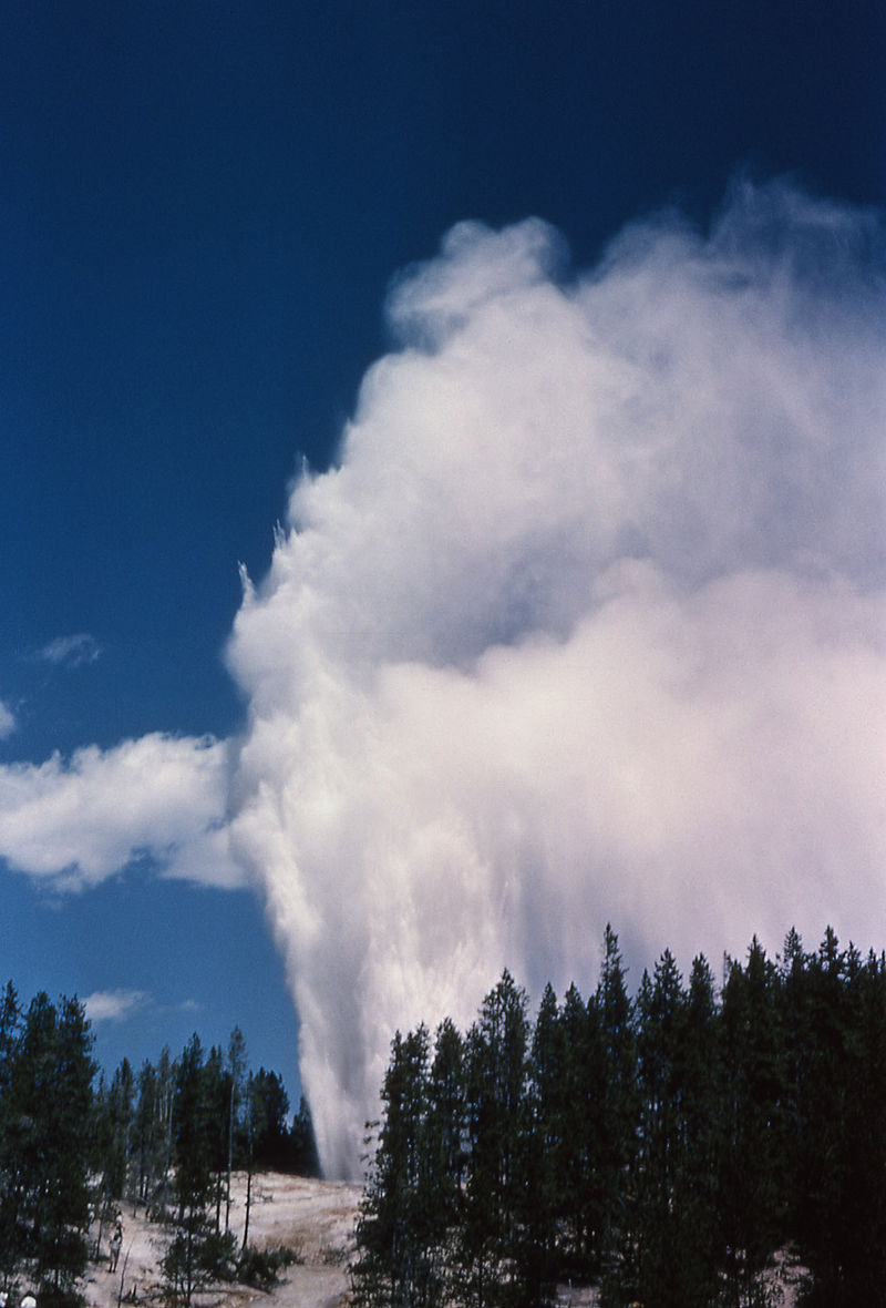 These days, at least in Wyoming, the news is often full of new eruption stories pertaining to Steamboat Geyser in Yellowstone National Park. Steamboat Geyser was dormant from 1911 to 1961. Eleven eruptions were noted between June 4, 1990 and September 23, 2014. Then beginning on March 15, 2018, we have seen a sudden increase in eruptions. Beginning on March 15th, there have been ten eruptions to date…just over three months. That is unheard of for this geyser in recorded history. In reality, it can do what Kilauea has done on Hawaii’s Big Island, only much bigger, because the geyser field in Yellowstone National Park lies on top of an active volcano, with multiple chambers of magma from deep beneath the earth. The same energy that causes geysers to blow could spew an ash cloud as far as Chicago and Los Angeles.
It’s strange to think about the fact that Yellowstone National Park lies on such a huge volcano, and yet three extremely large explosive eruptions have occurred at Yellowstone in the past 2.1 million years with a recurrence 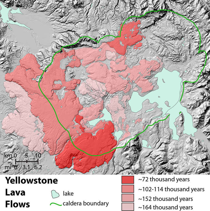 interval of about 600,000 to 800,000 years. More frequent eruptions of basalt and rhyolite lava flows have occurred before and after the large caldera-forming events. It is said that if the Yellowstone volcano erupted again, it it would be catastrophic, but with the chances of a supervolcanic paroxysm being currently around one-in-730,000, it is less likely than a catastrophic asteroid impact. I guess Wyomingites can breathe a little easier. Nevertheless, scientists do want to know what’s behind the most recent activity at Steamboat Geyser. “We see gas emissions. We see all kinds of thermal activity. That’s what Yellowstone does. That’s what it’s supposed to do. It’s one of the most dynamic places on earth,” said Mike Poland, the scientist in charge of the Yellowstone Volcano Observatory.
Steamboat Geyser is the least predictable geyser in all of Yellowstone National Park. It could erupt in five 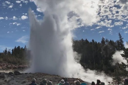 minutes, five years, or even 50 years from now. Yet no one visiting Yellowstone wants to turn away from the sight. “That would be the chance of a lifetime,” one visitor said. “I would be amazed.” Steamboat Geyser,is the world’s tallest and far more powerful than Old Faithful, and right now, it’s roaring back to life. Still, timing is everything, and only a few people get to see it. Poland’s team of volcanologists are using thermal-imaging equipment to track the temperature of the 50-mile-wide magma field. They also monitor 28 seismographs since a super volcano would include major earthquake activity. So far,there is no indication that this is anything other than an unusual series of eruptions, and not indication of increased volcanic activity, which puts many people’s minds at ease. The geyser is welcome to continue erupting, but I say, “Just leave that volcano alone.”
In April of 1993, my sisters, Cheryl Masterson, Alena Stevens, Allyn Hadlock, and I took a trip to the Seattle, Washington area where our sister, Caryl Reed and her family were living at the time. I had not been there before, and so was excited at the prospect. We planned to have dinner at the Space Needle, do some shopping, visit Friday Harbor, and the one I was most looking forward to, Mount Saint Helens. Since the mountain had blown up on May 18, 1980, I had been intrigued. My parents had gone there, but I was married and so didn’t go along. On that trip, because the roads there didn’t open until May, and this was April, the viewing of Mount Saint Helens was not to be, unfortunately. I was disappointed.
I will never forget hearing about the coming eruption in the news, on March 15, 1980. When we first heard about it, people were riveted to their televisions, but as time went on, I suspect that people got bored with it. After two months, it got to the point where we all wondered if it was just a false alarm. Then, at 8:32am Pacific Time on May 18, 1980, the mountain blew up…literally. Suddenly, everyone was riveted to the television again. It was just shocking, and since 9-11 had not happened yet, it seemed like the most shocking thing we had ever experienced…in my lifetime anyway. I remember going out to my car and finding ash all over it. I had a hard time believing that a volcano that was over a thousand miles away in Washington state, could dump ash on my 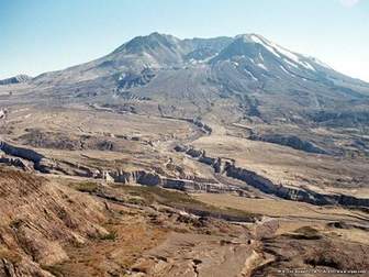 car in Casper, Wyoming. The ash went completely around the globe within a matter of days. Of course, it was nothing like what they had in the area surrounding the mountain.
When my daughter, Amy Royce and her husband Travis and son, Caalab moved to the Seattle area, and then decided to renew their vows, we decided to make the trip up for the ceremony. I wanted another chance to get to see Mount Saint Helens. My first attempt was thirteen years after the eruption, and that attempt was twenty two years ago. It was time. We had a rather small window of time to go see the mountain, with everything that has been planned at Amy’s house. So, Thursday was the day. Unfortunately, we seem to have picked the worst day of the days we would be here. Nevertheless, we went in the hope of a view of the…for me anyway…elusive Mount Saint Helens. Our grandchildren, Shai and Caalab Royce went with us. They were born well after Mount Saint Helens blew, and really knew very little about it…until today, that is.
Our first stop was to the visitors center, where we looked at the exhibits displayed there and watched a really good movie that told of the events leading up to and including May 18, 1980 and beyond. After we left, I think 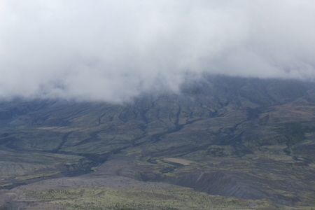 they had a much better idea about the magnitude of the whole event. We drove up to the area where we could finally view the mountain itself, only to find it sitting right there in front of us…completely shrouded in clouds and mist. We could see where the ash had landed and where the water and mud had carved out deep crevasses. We could see where erosion had taken its toll on the area, and where trees had been wiped out, and now rather small ones have grown up in their place. We could see the base of the mountain, and really, almost half way up it, but the now famous space left when the top that is no longer there blew, was still not visible to me. Sadly, I guess some things are simply not meant to be.
 After Mount Saint Helens blew up, and it had been deemed safe for tourism, my parents took a trip to Washington to visit my sister, Caryl and her family who were living in the Seattle area at the time. They decided to take a trip to see Mount St. Helens National Volcanic Monument. I’m not sure how many years after the eruption their trip was, but I do remember them telling me about how totally barren the whole place was. They told us about the buried cars and homes sticking out of the ash…broken and ruined. During that eruption, 57 people lost their lives, as well as countless numbers and species of wildlife. I can’t imagine the way that whole area must have felt to be in…so quiet and empty of life…almost like being on another planet.
Yes, it would be a trip of a lifetime…to be able to see an area devastated by a volcano  eruption. It is such a powerful act of nature, and yet, behind it all is such a great loss of life and destruction of such beautiful land, and in this case, even a loss of the beautiful mountain top, now forever changed. So many trees were destroyed, literally blown over and burned in minutes. It is so strange to think that one minute the area was filled with wildlife, trees, and flowers, not to mention people…and the next minute it was all gone. Yes, they knew it was coming, but I’m sure many people truly didn’t believe it would happen, or at least that it would not be as bad as it was. I think that if they could have known what was coming, they would have left the area, but their minds couldn’t wrap themselves around that reality…in fact I don’t think most of the nation expected the eruption to be what it was. I know I was shocked by how devastating it was.

It has been over 32 years since that shocking day in our nation’s history. When I came across the pictures of my parents’ trip through the area, I began to wonder what the area looks like now. It would seem that the area is slow to return to life, but then I suppose that ash makes poor soil for many things to grow in. Weeds might do ok there, but trees and grass…maybe not so much. I don’t know how my parents or my sister, Caryl and her family felt about the area, but their pictures told the story of a disaster of epic proportions.

