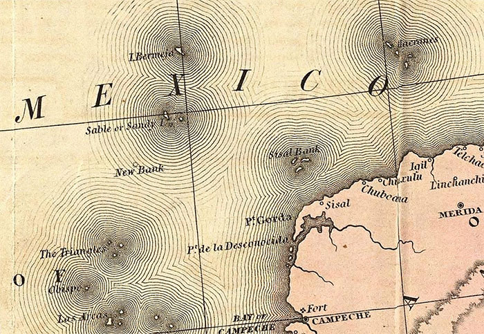
 For centuries there the maps of Mexico showed an island called Bermeja located off the north coast of the Yucatán Peninsula. It wasn’t a big island, but it was there. Then, suddenly, it wasn’t there. Now…islands don’t just disappear, so was it there, or wasn’t it, and if it was, where did it go? These days, it’s known as a phantom island. What’s interesting about this island is that a search for it found nothing that could have been called an island. While it is strange that an island was on a map and then wasn’t, I began to wonder why it mattered. There was a reason…oil rights. When a question arose concerning oil rights in the Gulf of Mexico, where the island was concerned, research started when someone pointed out that the island has no real boundaries, and therefore, no rights to oil in the Gulf of Mexico. So, authorities started looking for this piece of land, but they found only water. I’m sure that settled the question of oil rights, but it doesn’t explain whether or not the island ever existed, or if it was just an error on the old maps.
Of course, no pictures of the island are known to exist. All we know is that one century, it’s sitting pretty at 22°33′ N, 91°22 E in the Gulf of Mexico and the next, it’s vanished, confounding maritime investigations and aerial surveys alike. While it may seem to many people as no big deal, the Mexican people want to know where it went. It wasn’t inhabited, so you might wonder why it is so important to know if it did and if so, where it went. The thing is that while it wouldn’t be like the island of Jamaica went missing, it still changes what the Mexican people thought they knew about their world. For some people, that is akin to having your computer have a virus, and you can’t seem to get rid of it. Ok, maybe that is extreme, but in a techy world, that would be a good comparison.
Bermeja was a common fixture on maps drawn by Spanish explorers back in the 16th and 17th centuries. Strangely, its location sometimes varied slightly and sometimes its name appeared as Vermeja, but its existence was not in question at that time. In the 18th century, however, the island’s cartographic presence started faltering, before it eventually dropped off the horizon altogether. Its last mapped appearance dates back to the 1921 edition of the Geographic Atlas of the Mexican Republic. So, what happened to it? If you ask me it eroded away, but that is just my opinion. There are many theories regarding Bermeja’s mysterious fate. Some say that “global warming” caused the island to succumb to rising sea levels. Some wonder if an underwater earthquake caused it to denigrate. Then, there is the conspiracy theory that maybe, the CIA blow it up. They theorize that with a view to expanding US sovereignty in the oil-rich Gulf the island had to go. Others say that while that might be far-fetched, perhaps it’s not entirely impossible. I suppose that given its small size it might not have taken much to blow it up.
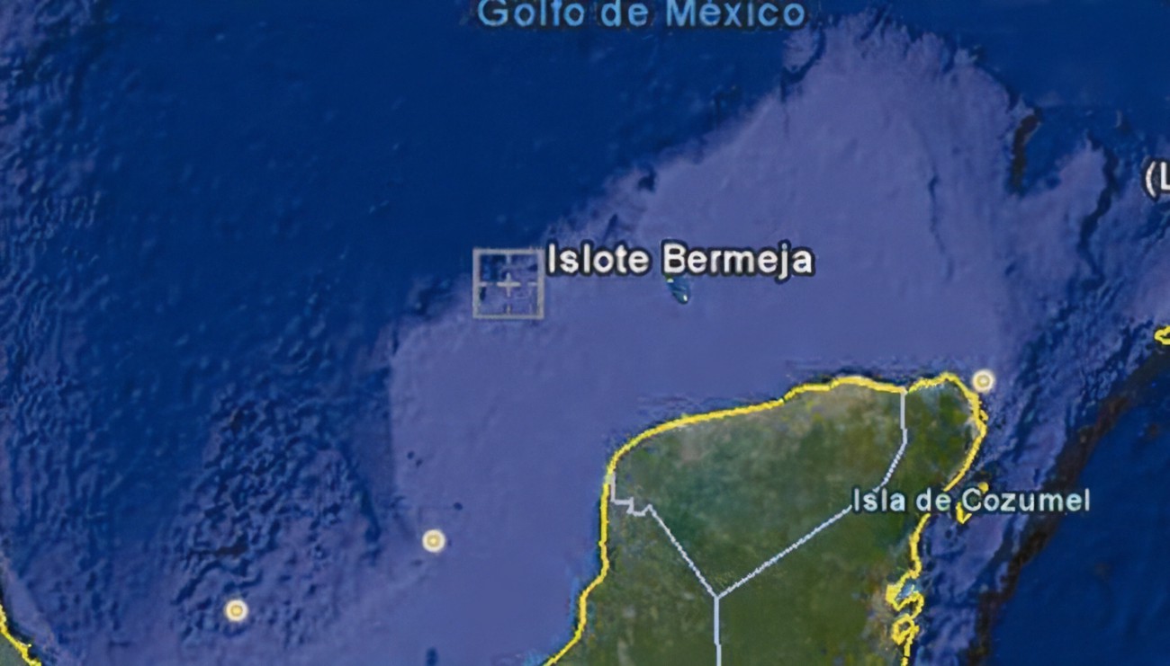
The Mexican and United States governments negotiated a treaty to divide Hoyos de Dona in 1997. Hoyos de Dona is a stretch of international waters taking in the area where Bermeja was once believed to be located. Now, the island mattered, so the Mexican government sent an expedition out to find it. The reason…if Bermeja did exist, it would significantly extend Mexico’s maritime limits and, more importantly, its right to the oil deposits within these limits. They found nothing, and the treaty was signed. Still, there was the authorized period of delay on oil exploration and exploitation in Hoyos de Dona, giving them a little time. That period of delay is to expire in 2010, Mexico started the hunt again. The implications for the country’s economy were just too appealing to ignore.
The “hunt” consisted of three official investigations that took place in 2009. All three used the most best technologies available at that time. They left “no wave unturned and no depth unplunged.” Nevertheless, Bermeja, nor any sign that it existed, could be found. There are those who think that it’s simply time to admit that the island never existed, and maybe it was invented by early explorers to mislead their rivals. Julio Zamora, president of the Mexican Society of Geography believes so, and says, “Countries making maps in the 16th and 17th centuries published them with inaccuracies to prevent their enemies from using them.” If ships saw an island on the map, they would avoid the area, thus allowing the map-makers free run of the area. I’m not sure why that would be important, but I suppose it’s possible, but Irasema Alcántara, from the Geography Institute at the Universidad Nacional Autónoma de México (UNAM), disagrees, saying “We’ve encountered 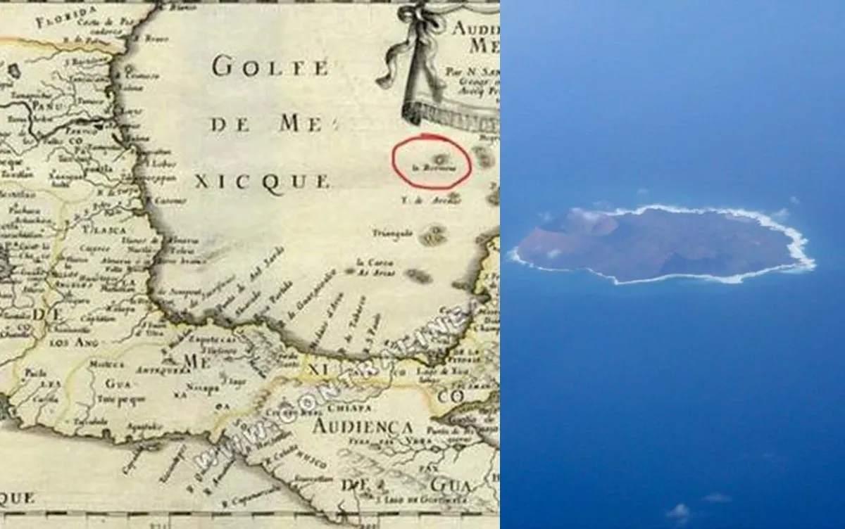
 documents containing very precise descriptions of Bermeja’s existence. On this basis we firmly believe that the island did exist, but in another location.” Well, now, that puts a whole new spin on an otherwise totally confusing situation. Maybe, we should just leave well enough alone and say, “Now you see it, now you don’t.” Highly unlikely.


Leave a Reply