landsat 1
 After the Soviet Union launched Sputnik, the world’s first satellite, on October 4, 1957, inspiring the United States to keep up, or fall behind in the Cold War, the United States launched it’s first satellite on January 31, 1958. That satellite was called Explorer 1, and followed the first two Soviet satellites the previous year…Sputnik 1 and 2. It was the beginning the Cold War Space Race between the two nations. Explorer 1 had mercury batteries that powered the high-power transmitter for 31 days and the low-power transmitter for 105 days. Explorer 1 stopped transmission of data on May 23, 1958 when its batteries died, but remained in orbit for more than 12 years. It reentered the atmosphere over the Pacific Ocean on March 31, 1970 after more than 58,000 orbits. The Explorer 1 payload consisted of the Iowa Cosmic Ray Instrument. It was without a tape data recorder, which was not modified in time to make it onto the spacecraft. The real-time data received on the ground was therefore very sparse and puzzling showing normal counting rates and no counts at all. I’m not sure what the counting was all about, so I guess I’m more confused than the scientists were. The later Explorer 3 mission, which included a tape data recorder in the payload, provided the additional data for confirmation of the earlier Explorer 1 data.
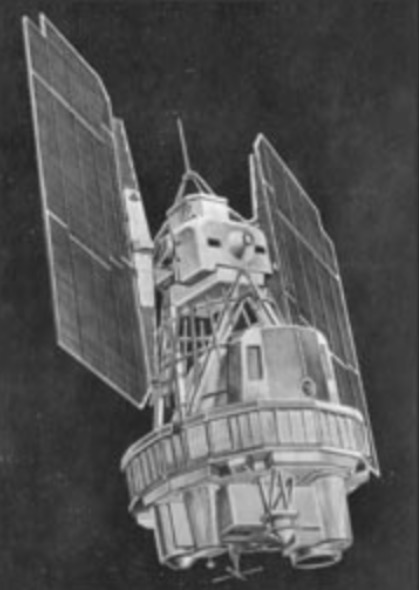
Landsat 1, which was originally named “Earth Resources Technology Satellite 1”, was the first satellite in the United States’ Landsat program. It was the first satellite that was launched with the sole purpose of studying and monitoring the planet. Landsat 1 was a modified version of the Nimbus 4 meteorological satellite and was launched on July 23, 1972 by a Delta 900 rocket from Vandenberg Air Force Base in California. Its orbit was near-polar and it served as a stabilized, Earth-oriented platform for obtaining information on agricultural and forestry resources, geology and mineral resources, hydrology and water resources, geography, cartography, environmental pollution, oceanography and marine resources, and meteorological phenomena. The spacecraft was placed in a sun-synchronous orbit, with an altitude between 564 and 569 miles. The spacecraft was placed in an orbit with an inclination of 99 degrees which orbited the Earth every 103 minutes. The project was renamed to Landsat in 1975.
Landsat 1 had two sensors to achieve its primary objectives…the return beam Vidicon (RBV) and the multispectral scanner (MSS). The RBV was manufactured by the Radio Corporation of America (RCA). The RBV obtained visible light and near infrared photographic images of Earth. It was considered the primary sensor. The MSS sensor manufactured by Hughes Aircraft Company was considered an experimental and secondary sensor, until scientists reviewed the data that was beamed back to Earth. After the data was reviewed, the MSS 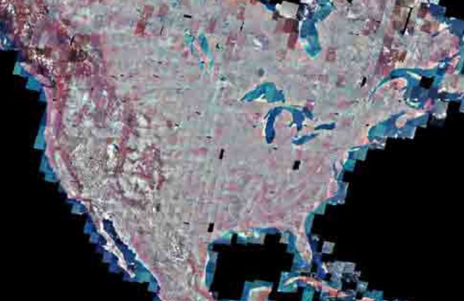 was considered the primary sensor. The MSS was a four-channel scanner that obtained radiometric images of Earth. From launch until 1974, Landsat 1 transmitted over 100,000 images, which covered more than 75% of the Earth’s surface. The RBV only took 1690 images. In 1976, Landsat 1 discovered a tiny uninhabited island 12 miles off the eastern coast of Canada. This island was named Landsat Island after the satellite. The MSS provided more than 300,000 images over the lifespan of the satellite. NASA oversaw 300 researchers that evaluated the data that Landsat 1 transmitted back to Earth. The Landsat 1 satellite sent data back to earth from its orbit until January of 1978 when its tape recorders malfunctioned. After that, it was taken out of service.

