Monthly Archives: December 2018
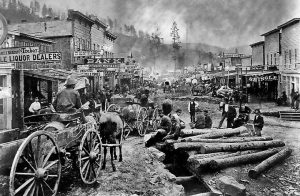 Anyone who has spent much time in the Black Hills has most likely seen Deadwood, and knows it to be a historic gambling town where many famous Wild West characters hung out and died. Legends like Wild Bill Hickok and Calamity Jane each left their mark. Hickok, a legendary man even in his own lifetime, was shot in the back of the head by Jack McCall, while playing poker at the No. 10 Saloon on August 2, 1876. Calamity Jane was renowned for her excellent marksmanship, as well as her preference for men’s clothing, and brash behavior.
Deadwood also had, in addition to its tough individuals, others such as Reverend Henry W. Smith. Preacher Smith was the first Methodist minister to come to the Black Hills. Smith was mysteriously murdered on Sunday, August 20, 1876, while walking to Crook City to deliver a sermon. These individuals are just a few of the many notables buried in Mount Moriah Cemetary, which was established in 1877 or 1878.
That’s all well known to many people, but some may not know that the settlement of Deadwood began illegally in the 1870s on land which had been granted to the Native Americans. In 1874, Colonel George Armstrong Custer led an expedition into the Black Hills and announced the discovery of gold on French Creek near what is now Custer, South Dakota. That announcement ushered in the Black Hills Gold Rush and gave rise to the new and lawless town of Deadwood. In 1875, a miner named John Pearson found gold in a narrow canyon in the Northern Black Hills. This canyon became known as “Deadwood Gulch,” because of the many dead trees that lined the canyon walls at that time. The name stuck. Try as they might, the government couldn’t keep the situation under wraps, in order to honor the 1868 Treaty of Fort Laramie, which forever ceded the Black Hills to the Lakota-Sioux. The government dispatched several military units to forts in the surrounding area to keep people from entering the Hills. However, people illegally entered the area anyway, searching for gold or adventure. Despite the efforts of the military and federal government. They were driven by dreams and greed.
Once Deadwood was established, the mining camp was quickly swarming with thousands of prospectors searching for an easy way to get rich. Fred and Moses Manuel, claimed the Homestake Mine, which proved to be the most profitable in the area. Although the Manuels had been lucky, others were not so fortunate. Most of the early population was in Deadwood to mine for gold, but the lawless town naturally attracted a crowd of rough and shady characters too. These particular individuals made the early days of Deadwood rough and wild. 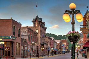 A mostly male population eagerly patronized the many saloons, gambling establishments, dance halls, and brothels. These establishments were considered legitimate businesses and were well known throughout the area.
In 1890, the railroad connected the town to the outside world. Illegal beginnings aside, Deadwood was a town that was now here to stay. The treaty with the Lakota-Sioux was broken and the Black Hills would never again belong to them. As unfair as it was to break the treaty, I don’t think that it could have lasted forever anyway, because the United Stated was going to be populated from coast to coast one way or the other.

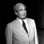 It’s no secret that various governments have had secret projects over the years to create bigger and better weapons of war to be used against enemy governments in the event of a war. I think that there are those who believe that only rogue countries do this sort of thing, but that isn’t so. In the United States, where Enrico Fermi, an Italian physicist and the creator of the world’s first nuclear reactor, and Leó Szilárd a Hungarian-German physicist and inventor; had both emigrated to America, the discovery of the nuclear chain reaction led to the creation of the first man-made reactor, known as Chicago Pile-1, which achieved criticality on December 2, 1942. This work became part of the Manhattan Project, a massive secret U.S. government military project to make enriched uranium and by building large production reactors to produce enriched plutonium for use in the first nuclear weapons. The United States would test an atom bomb in July 1945 with the Trinity test, and eventually two such weapons were used in the atomic bombings of Hiroshima and Nagasaki. Of course, weapons of warfare are not the only use for nuclear power, but they are what most of us think about when we think about going nuclear.
In reality, much more has come from nuclear energy. In August 1945, the pocketbook The Atomic Age, became the first widely distributed account of nuclear energy. It discussed the peaceful future uses of nuclear energy and painted a picture of a future where fossil fuels would go unused. Nobel laureate Glenn Seaborg, who later chaired the Atomic Energy Commission, is quoted as saying “there will be nuclear powered earth-to-moon shuttles, nuclear powered artificial hearts, plutonium heated swimming pools for SCUBA divers, and much more.” Then, on December 20, 1951, came the first light bulbs ever lit by electricity generated by nuclear power at EBR-1 at Argonne National Laboratory West.
Nuclear power is still producing electricity today. The United States has more than 100 reactors, although it creates most of its electricity from fossil fuels and hydroelectric energy. Nations such as Lithuania, France, and Slovakia create almost all of their electricity from nuclear power plants. Uranium is the fuel most widely used to produce nuclear energy. I think most people have heard of the disasters at Chernobyl, April 26, 1986, Kyshtym, September 29, 1957, Three Mile Island, March 28, 1979, and Windscale, October 10, 1957. Some were worse than others, but all were scary situations. I don’t know how I feel about the use of nuclear power as opposed to fossil fuels, hydroelectric energy, or wind energy, because I think that quite possibly each has their place, and that it would be difficult to rely on just one type of fuel.
The United Kingdom, Canada, and the USSR continued to research and develop nuclear industries over the course of the late 1940s and early 1950s. Electricity was first generated by a nuclear reactor on December 20, 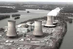 1951, at the EBR-I experimental station near Arco, Idaho, which initially produced about 100 kW. In the United States work was also strongly researched on nuclear marine propulsion, with a test reactor being developed by 1953…eventually, the USS Nautilus, the first nuclear-powered submarine, would launch in 1955. Then, in 1953, President Dwight Eisenhower gave his “Atoms for Peace” speech at the United Nations. In it he emphasized the need to develop “peaceful” uses of nuclear power quickly. The concern was over any further us in war situations. This was followed by the 1954 Amendments to the Atomic Energy Act which allowed rapid declassification of United States reactor technology and encouraged development by the private sector.
 Recently, I became interested is unusual military bases, after coming across on called RAF Rudloe Manor…an English military base that looked, and in fact was an old English manor. Another military base, this one in the United States, in Virginia, near Dulles International Airport, has now come to my attention, but for multiple reasons. Mount Weather Emergency Operations Center is a civilian command facility in the US Commonwealth of Virginia, used as the center of operations for the Federal Emergency Management Agency (FEMA). Also known as the High Point Special Facility (HPSF), its preferred designation since 1991 is “SF”.
Mount Weather Emergency Operations Center gained some “fame” for a completely different reason in 1974. December 1, 1974 was a windy, stormy day in the Washington DC area. Trans World Airlines Flight 514 was en route from Indianapolis, Indiana, and Columbus, Ohio, to Washington Dulles International Airport, but was originally supposed to land at Washington National Airport. The Boeing 727-231, registration N54328, was diverted to Dulles when high crosswinds, east at 32 mph and gusting to 56 mph, prevented safe operations on the main north-south runway at Washington National. The flight was being vectored for a non-precision instrument approach to runway 12 at Dulles. Air traffic controllers cleared the flight down to 7,000 feet before clearing them for the approach while not on a published segment. At this point, there was some confusion in the cockpit over whether they were still under a radar-controlled approach segment which would allow them to descend safely, or not. The jetliner began a descent to 1,800 feet, shown on the first checkpoint for the published approach. After reaching 1,800 feet there were some 100 to 200 foot altitude deviations which the flight crew discussed as encountering heavy downdrafts and reduced visibility in snow. Nevertheless, their tower controlled approach had ended.
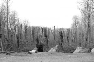
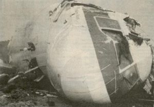
In the stormy conditions, late on that Sunday morning, the aircraft was in controlled flight, when it impacted a low mountain about thirty miles northwest of its revised destination. That mountain was Mount Weather, Virginia, where the Mount Weather Emergency Operations Center was located. The plane impacted the west slope of Mount Weather at 1,670 feet above sea level at approximately 265 mph. The wreckage was contained within an area about 900 by 200 feet. The evidence of first impact were trees sheared off about 70 feet above the ground…the elevation at the base of the trees was 1,650 feet. All 92 aboard, 85 passengers and seven crew members, were killed. “The wreckage path was oriented along a line 118 degrees magnetic. Calculations indicated that the left wing went down about six degrees as the aircraft passed through the trees and the aircraft was descending at an angle of about one degree. After about five hundred feet of travel through the trees, it struck a rock outcropping at an elevation of about 1,675 feet. Numerous heavy components of the aircraft were thrown forward of the outcropping, and numerous intense post-impact fires broke out which were later extinguished. The mountain’s summit is at 1,754 feet above sea level.”
“The accident investigation board was split in its decision as to whether the flight crew or Air Traffic Control were responsible. The majority absolved the controllers as the plane was not on a published approach segment; the dissenting opinion was that the flight had been radar vectored. Terminology between pilots and controllers differed without either group being aware of the discrepancy. It was common practice at the time for controllers to release a flight to its own navigation with “Cleared for the approach,” and flight crews commonly believed that was also authorization to descend to the altitude at which the final segment of the approach began. No clear indication had been given by controllers to Flight 514 that they were no longer on a radar vector segment and therefore responsible for their own navigation. Procedures were clarified after this accident. Controllers now state, “Maintain (specified altitude) until established on a portion of the approach,” and pilots now understand that previously assigned altitudes prevail until an altitude change is authorized on the published approach segment the aircraft is currently flying. Ground proximity detection equipment was also mandated for the airlines.”
During the NTSB investigation, it was discovered that a United Airlines flight had very narrowly escaped the same fate during the same approach and at the same location only six weeks prior. Apparently, the problem was bigger than it was first thought to be. The crash is also noteworthy, because of the accident location. The undesired attention to the Mount Weather facility, became the unfortunate side effect, because the site was the linchpin of plans implemented by the federal government to ensure continuity in the event of a nuclear war. 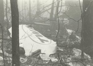
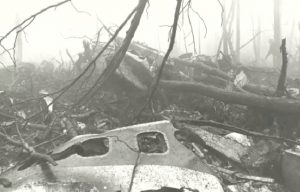 The crash did not damage the facility, since most of its features were underground. Only its underground main phone line was severed, with service to the complex being restored by C&P Telephone within 2½ hours after the crash. Nevertheless, the crash brought to light the possibility of damage to an important facility by a plane crash, which was a distinct possibility due to the flight path of planes landing at Dulles International Airport.

