shipwreck
 During World War II and really with any war, any coastal area of the United States had to be kept on a higher alert than during peacetime. Coastal defense networks now are much more technological that they were in 1943. During World War II, the West Coast was patrolled by units of men whose job it was to watch for activities that were out of the ordinary along the Olympic Coast of Washington. Normally, their job was pretty boring, unless you liked walking or driving along the coast looking at the ocean. There were ships out there, but most of them were where they were supposed to be and were not cause for concern.
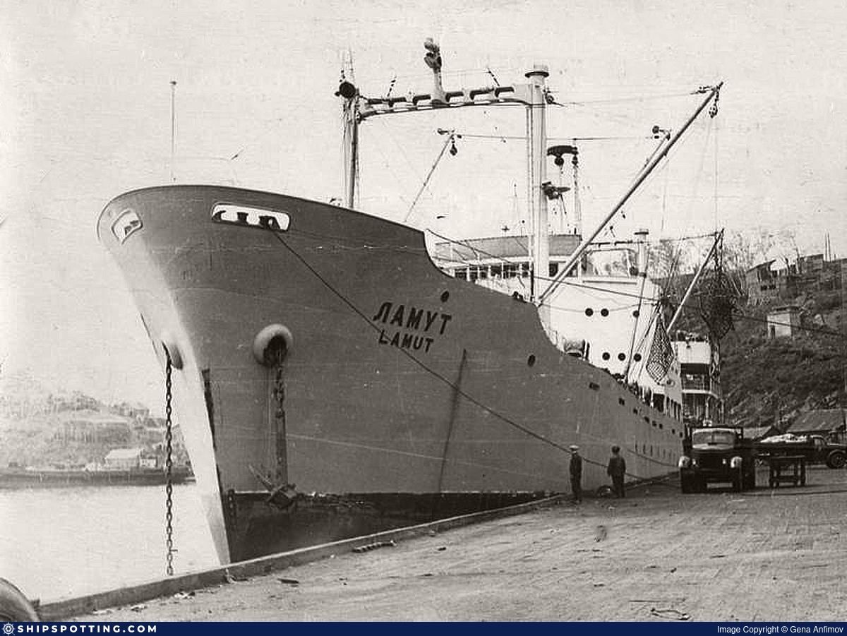
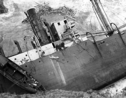
In the early spring of 1943, however, coastal lookout activities along the Olympic Peninsula suddenly took a turn from the mundane to something quite unusual. As the La Push unit patrolled the beach that day, they suddenly began to see debris on the beach. That is never a good thing to see, because it means that somewhere, there is a ship in a lot of trouble. Rain, wind, and heavy seas just before midnight on April 1st, were driving the Russian steamship Lamut toward the shoreline, and behind a jagged cluster of rocks just off Teahwhit Head. By the early morning hours of April 2nd, the ship was in great peril, and the lives of the crew hung in the balance.
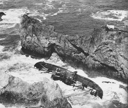
The La Push patrol unit was in for an intense morning, as they would find at first light on April 2nd. When the  patrolmen began finding wreckage on the beach, they headed south along the beach to see if they might find the ship in trouble. It wasn’t long before they sighted part of the grounded ship. It was lodged between a hundred-foot cliff and a small, jagged rock island. Amazingly, there were survivors huddled high on the steeply sloping deck of the Russian ship called Lamut. They wouldn’t have lasted long on that deck, but the high seas made a sea rescue impossible. The coast guardsmen of the La Push Unit decided to attempt a rescue by land. That would be pretty treacherous in itself, but they had no other choice.
This would not be a quick rescue. By mid-morning, the members of the rescue party had cut a path through the thick underbrush bordering the beach. Then, they began their ascent along the slippery boulders to the top of the cliff above the smashed ship. They would have to get very creative in their rescue maneuvers. “Using gauze bandage weighted with a rock, a light line was lowered to the eager hands of the stranded crew aboard the Lamut. Tying heavier line to the gauze, one line succeeded another until a lifeline strong enough to support the weight of a single person was stretched between the ship and the cliff. One by one survivors were raised to the cliff top and finally assisted down the landward side of the rocky ridge to the beach below. As darkness approached, the last of the Lamut survivors emerged from the swampy beach trail to waiting coast guard trucks and ambulances.” The rescue of the Lamut crew was among the most dramatic events in the annals of World War II beach patrol history.
While this was just one of the rescues conducted by the Olympic Defense Network, it was undoubtedly the most intense rescue they performed in their years of service. On March 29, 1944, the beach patrol ended and a week 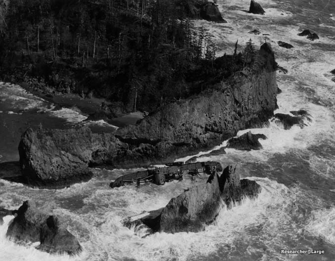
 later the unit decommissioned. The trails in that area are now a part of the Olympic National Park probably date from the era of World War II beach patrol activities. A while back, a small, collapsed wood frame cabin was located at Teahwhit Head. It is believed to be associated with World War II beach patrolling activities in the La Push unit, and quite possibly belongs to the Lamut.
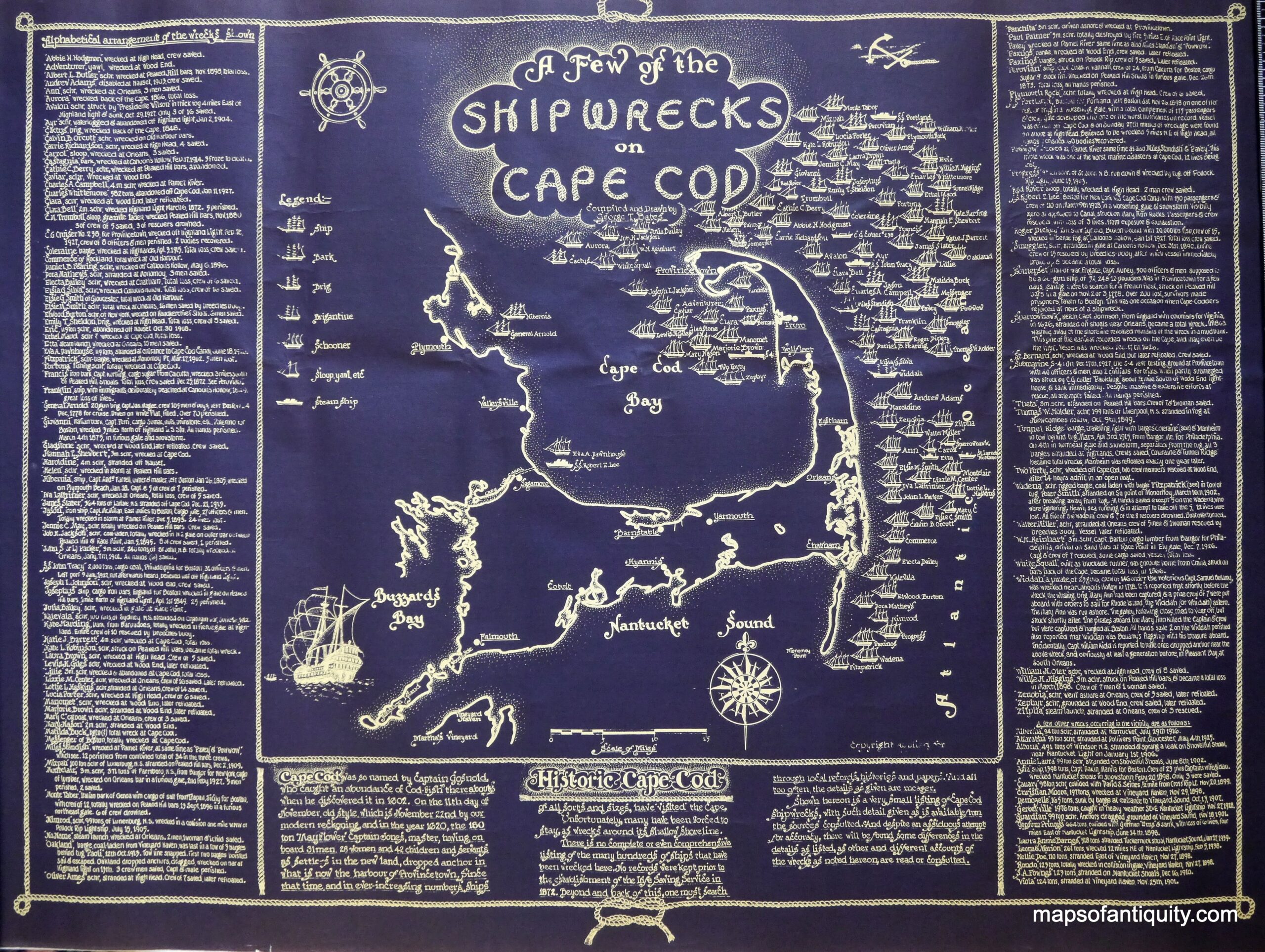
 The dangers of the Cape Cod shoals are well known to the seamen who regularly navigate those waters. Almost from the time the shoals were discovered, they have been wreaking havoc on the ships that have the misfortune of getting too close to them. Sailors know that they need to steer clear of the Cape coast. Thousands of ships have been destroyed on its bars and rocks, and with the lost ships, uncounted lives too have been lost in the storm-tossed waves. When the storms were raging and a ship got caught, there was no way for rescuers to get to the trapped crew and passengers. The storms battered the trapped ships until they sank.
Oddly, Cape Cod is both a hazard and a haven to the mariners. All shipping between Boston and New York must either pass into its sheltered bay or run aground on its treacherous shoals. It is only the skill of the mariners that determines the difference. The shoals, when combined with the forces of 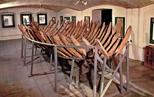 countless Nor’easters put the Cape in a precarious location. Because of this, the Cape has been the site of more than 3,000 shipwrecks in 300 years of recorded history.
One of the first recorded wrecks was that of the Sparrow Hawk. The Sparrow Hawk originally hailed from London, England. It was making a six-week voyage to Virginia when it ran aground off Nauset Harbor in 1626. A gale arose and forced the vessel over the bar into the harbor. The ship ran aground near Orleans. The area isn’t always so dangerous. When the tide is low, people aboard the ships were able to get ashore safely when their ships ran aground. When Sparrow Hawk grounded, some English-speaking Indians arrived and offered to conduct them to Plymouth or carry a message. Grateful, they accepted and once ashore, they sent a message which brought Governor William Bradford with repair material. The ship was soon repaired, but before it could set sail, the ship was sunk by another storm. The sunken ship was abandoned.
The second wreck would be more permanent, as the ship wasn’t seen for over 200 years. The wreckage reappeared on May 6, 1863, after the sand shifted. The exposed remains of the ship reappeared only briefly. Because of the vessel’s unusual shape, two local men made a drawing of it. The ship was an oddity, and it drew many visitors. The visitors, when they came to see, nearly all took a fragment of the ship for a souvenir before it was again covered by sand in August of 1863. Since they now knew where the ship was, it has since been excavated, and the ribs of the ship were removed and transferred to the Pilgrim Hall Museum in Plymouth, where it is to this day.
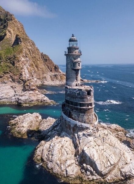 I like lighthouses. That is just a fact. I am particularly fascinated with unusual lighthouse. There are many lighthouses all over the world. They are, of course, used to direct ships away from shallow waters or dangerous rocks that lurk below the surface of the water. Today, there are more than 21,600 lighthouses worldwide, and there are a few that are still in use. In pre-GPS days, they played a vital role in the shipping industry, but these days they are usually used as tourist attractions. Many are privately owned, and are only used in an extreme emergency, when the electronic guidance systems are down. Some lighthouses are simply abandoned. I have mixed feelings about those, because when abandoned, they usually fall into disrepair, but there is something about abandoned buildings that has always intrigued me…even when they have fallen into disrepair.
One such unusual, abandoned lighthouse is the Aniva Lighthouse in Sakhalin, Russia. The lighthouse is situated on a small rock called Sivuchya near the rocky Cape Aniva. It is difficult to reach, and can only be accessed by water. To make matters worse, the tides are strong there. Still, the breathtaking scenery makes the journey worth while. Construction started on Aniva Lighthouse in June 1937 and finished in October 1939, taking just over two years. Building this navigational structure was difficult: all of the construction materials had to be delivered by water. Severe weather conditions didn’t make the process any easier.
When I first saw a picture on the Aniva Lighthouse, it reminded me of the front of a ship. It almost looked like a 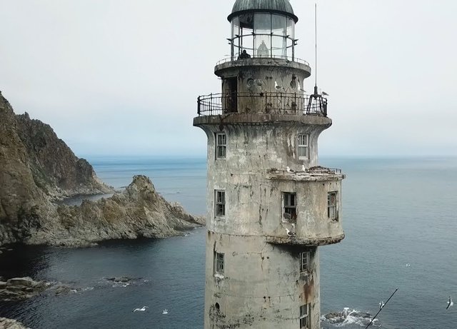 shipwreck, except for the lighthouse part, of course. Upon closer inspection, the lighthouse really doesn’t look like a ship at all, but maybe it was designed to give that illusion. The concrete tower, is painted to match the surrounding rocks, its stroboscopic lamp located 131 above the ground. The structure is round in shape and equipped with a bay window, the 9-floor tower stands on an oval base, which looks like it is coming out of the coastal rocks. Maybe that’s why it looks like a ship.
The Aniva Lighthouse was well equipped for living, no matter what the weather conditions. The basement was equipped with diesel engines and batteries. The kitchen was located on the ground floor along with the food storage The radio room, equipment room, and watch room were situated on the second floor of the lighthouse. As many as 12 people could be accommodated in the living quarters, located on the third, fourth and fifth floors, with each floor having a separate room. The interior of the quarters was modest, housing two bunk beds and small alcoves for personal belongings. Much of the light came in through small porthole windows. The storeroom was on the sixth floor. The seventh floor housed the mechanisms of a pneumatic siren, with its horn installed directly on the roof of the bay window. The eighth floor was used for fuel storage. The ninth floor housed the lens rotation mechanism of the lighthouse. The lantern rotated inside a bowl with about 660 pounds of mercury. The stroboscopic lamp was set in motion by a mechanism similar to a clockwork. Running through 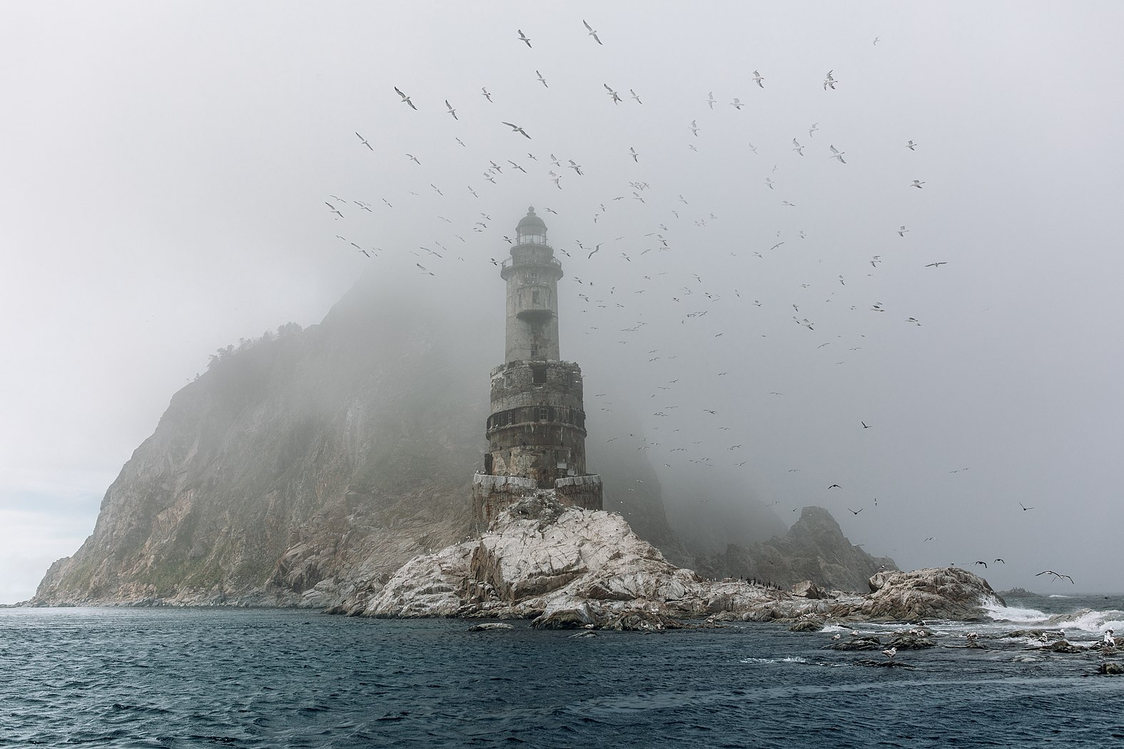 the center of a spiral staircase leading to the very top of the tower, was a pipe with a suspended weight of 595 pounds inside. It took the weight three hours to reach the bottom, rotating the lamp in the process. After that, the lighthouse keeper had to rewind the system. The lighthouse had a range of 17.5 miles. That must have been a job.
It was decided to make the Aniva Lighthouse autonomous by re-equipping it to work from a nuclear power source in the 1990s. In 2006, the radioisotope generators were removed. The lighthouse has been abandoned ever since. These days it is a haven for the birds.
 Most kids have, at one point or another, imagined that they were hunting for lost treasure. Some people, however, continue to be treasure hunters well into adulthood. Such was the case with two Michigan-based treasure hunters in 2011. The men were hunting for gold in Lake Michigan. Of course, that doesn’t mean they were looking for gold nuggets, like the gold rush days of old. They were looking for gold in the many shipwrecks of the Great Lakes.
On this particular treasure hunting expedition, Kevin Dykstra and Frederick Monroe were searching for $2 million in gold that had, according to local legend, fallen from a ferry crossing Lake Michigan in the 1800s. While moving their sonar over the lake, it caught a mass below. Dykstra dove into the water to video the mass. “I didn’t go down there with the expectation of seeing a shipwreck–I can tell you that,” Dykstra told Live Science. Nevertheless, there beneath the cold waves of Lake Michigan was an aging shipwreck. Brown and gray zebra mussels, encrusted the wooden planks of the old ship. When Dykstra and Monroe reviewed the video, they realized that the ship might be the remnants of a 17th-century ship called the Griffin, or Le Griffon. French explorer René-Robert Cavelier, Sieur de La Salle built the ship in 1679. It was lost in Lake Michigan the same year.
Some experts were not convinced that the men had indeed found the Griffin. The experts thought it might be the remnants of a tugboat that was scrapped after “steam engines became more economical to operate,” said Brendon Baillod, a Great Lakes historian, who has written scholarly papers on the Griffin. More evidence was needed to prove that this ship was the Griffin. State archaeologists reviewed the footage, and “They’ve been very diligent to say, ‘This is really interesting; these are some neat pictures,'” Dykstra said. “Can we call this the Griffin? Certainly not–not without a lot more information–but these are very compelling.”
La Salle apparently sailed the Griffin through the Great Lakes and crossed into Lake Michigan in an effort to reach the mouth of the Mississippi River, according to Baillod. Running out of money, he disembarked with the other expedition leaders, leaving the ship and its crew to pay off his debts with furs. “La Salle never saw the Griffin again. La Salle returned to the area in 1682, to try again to locate the Mississippi’s mouth. But members of the Potawatomi tribe brought pieces of the ship to the explorer, including some moldy beaver furs and a pair of sailor’s britches,” said Baillod, who translated La Salle’s journal from French to English.
The Native Americans told La Salle that the crew planned to sail toward the Straits of Mackinac in stormy weather. “The [American] Indians told the captain not to sail out, to wait the storm out, but he wouldn’t listen to them,” Baillod said. Of course, because of his haste to set sail, the captain lost control of the ship in the strong winds. The ship was blown away from shore, southward, toward some islands in the distance. “They lost the ship from sight,” Baillod said, “and that’s the last anybody has ever seen the Griffin.”
About 30 various adventurers have claimed to have found the Griffin, but have never really been able to prove their claim. “They’re looking for something else, they find an old ship and they’ve heard of the Griffin, so they pronounce it the Griffin,” Baillod said. According to Baillod, none of these adventurers were looking near the Beaver Island area, which was most likely the area the ship went down. But the latest finding, made popular again by Wreck Diving Magazine in its latest issue, holds a number of clues about the ship’s past. “There was no rudder on the boat,” Dykstra said. “That was kind of telling to us that the ship probably weathered a storm; otherwise, there would probably be a rudder on it.” They also found a part of the ship that they said could be a mussel-covered griffin, the mythical beast carved onto the ship’s bow.
Dykstra was so intrigued that he went back to have another look. He took a magnet with him to help determine the metal composition of the ship. Purely by accident, a nail attached itself to the magnet. The treasure hunters discovered it later, once they were above water. “When we had it looked at, they [the archaeologists] could tell that the nail was very old,” Dykstra said. “It was a hand-forged nail, which helps date it back to that time period, we feel.” Of course, this accident could have landed the men in hot water with the state of Michigan, which has rules stipulating that artifacts found on state land, including the land at the bottom of the Great Lakes, are state property. “The two men did not bring up the nail on purpose, and they plan to return it to the state,” said Dean Anderson, the state archaeologist for Michigan.
About 1,500 shipwrecks have been found on the bottom of Lake Michigan, Anderson said, and it’s unclear whether this one is the Griffin. “It’s very difficult to access a wreck based on photo and film footage,” Anderson said. If the state underwater archaeologist were to look at the wreck, he would look for artifacts that could be 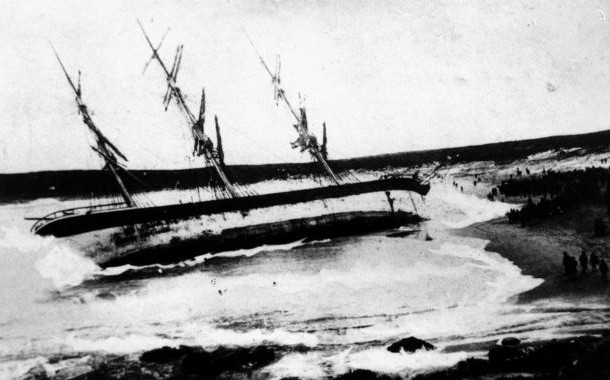 dated, such as ceramics or glass. Baillod is “99 percent sure” that the wreck is not Le Griffon. The figurehead likely isn’t the remains of a griffin, but a “big encrustation of zebra mussels,” on burned wood. He noted that the wreck is near the western Michigan coast, not near Beaver Island, the area mentioned in La Salle’s journal. Nevertheless, Dykstra and Monroe said they’ll wait until they hear the final word. They’re not going back to the wreckage for a while, so they don’t make the site vulnerable to other treasure seekers. In the meantime, the duo plans to continue their hunt for the gold bullion. “It’s a mystery ship that got in our way,” Dykstra said, “and now, we’re going for the gold.”

 Shipwrecks on the Great Lakes are not a totally uncommon event. Over the last 300 years, Lake Michigan has claimed countless ships, mostly in violent storms and bad weather, especially when the gales of November come in. Nevertheless, a few ships went down without even reaching open waters. One of those ships was the SS Eastland, which went down while docked between LaSalle and Clark Streets on the Chicago River. That site and that ship became the site of the greatest loss of life on the Great Lakes, and it wasn’t a fire, explosion, or act of war, but rather something far more strange.
The SS Eastland was built by the Michigan Steamship Company in 1902 and began regular passenger service later that year. In July 1903, the ship held an open house so the public could have a look. The sudden number of people, particularly on the upper decks, caused the Eastland to list so severely that water came in through the gangways where passengers and freight would be brought aboard. The ship was obviously top-heavy and this problem had to dealt with quickly, but these incidences continued to plague the ship. In 1905, the Eastland was sold to the Michigan Transportation Company. During the summer of 1906, the Eastland listed again as it transported 2500 passengers, and her carrying capacity was reduced to 2400. But in July 1912, the Eastland was reported as having once more listed to port and then to starboard while carrying passengers. In 1915, the LaFollette Seaman’s Act, which was created as a response to the Titanic not carrying sufficient lifeboats, was passed. The Seaman’s Act mandated that lifeboat space would no longer depend on gross tonnage, but rather on how many passengers were on board. However adding extra weight to the ship put top-heavy vessels like the Eastland at greater risk of listing. In fact, the Senate Commerce Committee was cautioned at the time that placing additional lifeboats and life rafts on the top decks of Great Lakes ships would make them dangerously unstable. This was a warning that the Senate Committee and the Eastland should have heeded.
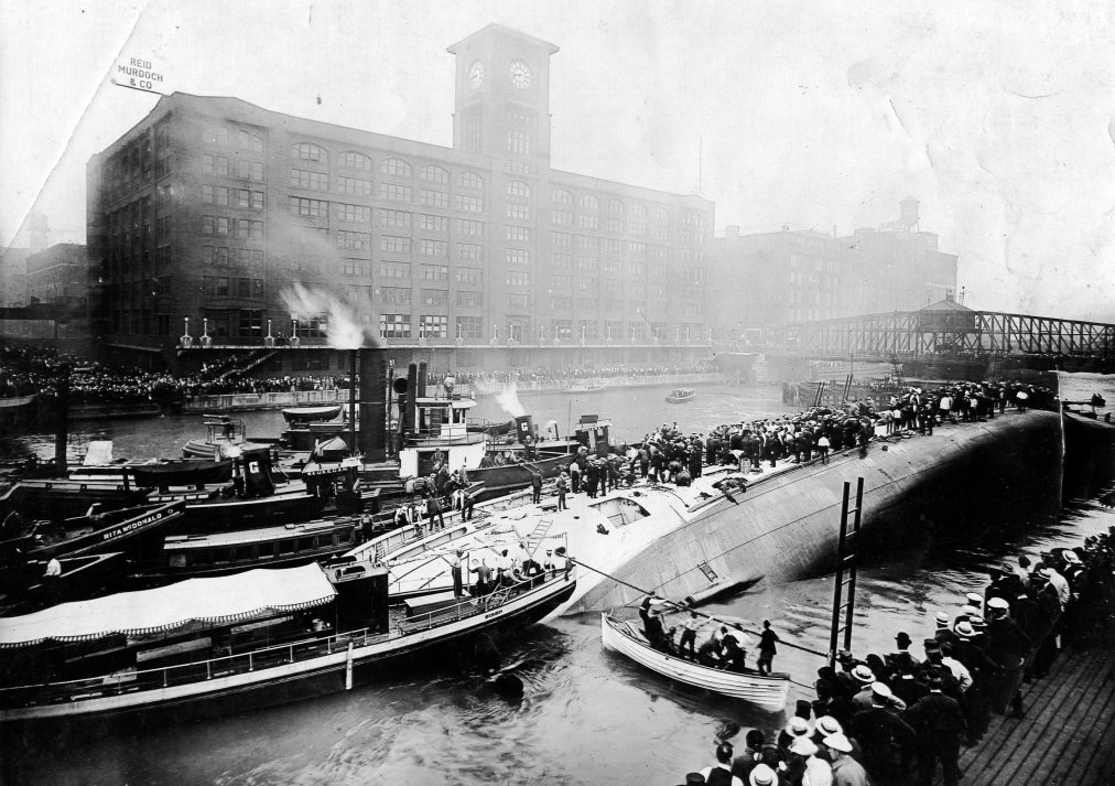
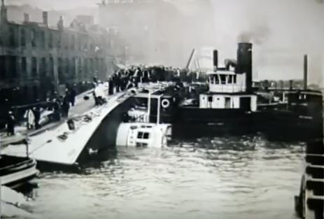
On July 24, 1915, the Eastland once again fell victim to its top heavy design, and this time the outcome was disastrous. On that cool Saturday morning in Chicago, the Eastland and two other steamers were waiting to take on passengers bound for an annual company picnic in Michigan City, Indiana. For many of the employees of Western Electric Company’s Hawthorne Works, this would be the only holiday they would enjoy all year. A large number of these employees from the 200-acre plant in Cicero, Illinois were Czech Bohemian immigrants. Excitement was in the air as thousands of employees thronged along the river. Three ships would transport them across Lake Michigan to the picnic grounds in Indiana. The Eastland was slated to be the first ship boarded. That morning the Eastland was docked between LaSalle and Clark Streets on the Chicago River. As soon as passengers began boarding, Captain Harry Pedersen and his crew noticed that the ship was listing to port even though most passengers were gathered along the starboard. Attempts were made to right the vessel, but stability seemed uncertain. At 7:10am, the ship reached its maximum carrying capacity of 2572 passengers and the gangplank was pulled in.
As the captain made preparations to depart at 7:21am, the crew continued to let water into the ship’s ballast tanks in an attempt to stabilize the vessel. At 7:23am, water began to pour in through the port gangways. Within minutes, the ship was seriously listing but most passengers seemed unaware of the danger. I wondered how this could have continued to happen, until I saw this video, that explained it very well. By 7:27am, the ship listed so badly that passengers found it too difficult to dance so the orchestra musicians started to play ragtime instead to keep everyone entertained. Just one minute later, at 7:28am, panic set in. Dishes crashed off shelves, a sliding piano almost crushed two passengers, and the band stopped playing as water poured through portholes and gangways. In the next two minutes, the ship completely rolled over on its side, and settled on the shallow river bottom 20 feet below. Passengers below deck now found themselves trapped as water gushed in and heavy furniture careened wildly. Men, women and children threw themselves into the river, but others were trapped between decks, or were crushed by the ship’s furniture and equipment. The lifeboats and life jackets were of no use since the ship had capsized too quickly to access them. In the end, 844 people lost their lives, including 22 entire families. It was a tragedy of epic proportions.
Bystanders on the pier rushed to help those who had been thrown into the river, while a tugboat rescued passengers clinging to the overturned hull of the ship. An eyewitness to the disaster wrote: “I shall never be able to forget what I saw. People were struggling in the water, clustered so thickly that they literally covered 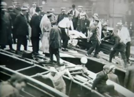
 the surface of the river. A few were swimming; the rest were floundering about, some clinging to a life raft that had floated free, others clutching at anything that they could reach…at bits of wood, at each other, grabbing each other, pulling each other down, and screaming! The screaming was the most horrible of them all.” Yes, I’m sure that was the worst, and the loss of life was something that would never be forgotten…especially for an eye witness.
 When my daughter, Amy Royce and her family first moved to the Seattle, Washington area, I started looking around online to see what sights there might be for them to go visit. The first thing I came across was the Pacific Queen shipwreck. I was excited to tell them about a shipwreck in their area. I thought it might be a cool thing to go see. Amy researched it too, and found that it was on a private beach. We were disappointed, but I couldn’t get it off my mind.
Bob and I had a little time on Saturday, so we decided to head back out to Puget Sound. I got an idea to see if there was a place where we could actually see the ship, and found that we could see it from Picnic Point Park. While we could not get close to the private beach where the Pacific Queen rests, we were treated to some really good views of the ship, 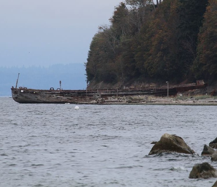 and I was so excited. This was something I really wanted to see.
I started researching the origins of the Pacific Queen online, I found that she was a old minesweeper. The ship was not wrecked, but rather brought to the site by a man who planned to salvage the metal on her. So the only wreck she had was when she was run aground to her final resting place. The Pacific Queen is one of 27 boats that were brought to the sight over the years, but she is the only one that really still resembles a ship. Several of the boats are underwater except during low tide, and those still look somewhat like ships too.
I admit that I was a little disappointed that it wasn’t an actual shipwreck, but then again, the ship was built in the 1800s. It was actually brought to its current location in 1929, and really has been an area attraction since that time. The best way to get up close is by kayak, but the beach is off limits. Apparently you can walk the distance from Picnic Point Park to the Pacific Queen during the low tide, but it is not recommended that you go onto the actual beach. Nevertheless, a few people have ventured close, and if the owner was in a good mood, they might have been treated to a few of the stories surrounding the boats and their arrival at the current sight.
 In the end, with the boat viewing and my research, I felt very pleased with this adventure. Whether she had wrecked or not, the Pacific Queen was a very cool boat. It was amazing to sit and wonder where she had been and what she and her crews had seen. A minesweeper must have been an important boat, and I would think that would be a dangerous job. If you didn’t see a mine and you bumped into it…well, it was all over for you. Nevertheless, the crews of the Pacific Queen must have been good at their jobs, because she survived the war and ended up on her current resting place, a ship of beauty and intrigue, sought out by many and having her picture on the Internet for all to see. I know that for me, it was a view I will never forget.

