agriculture
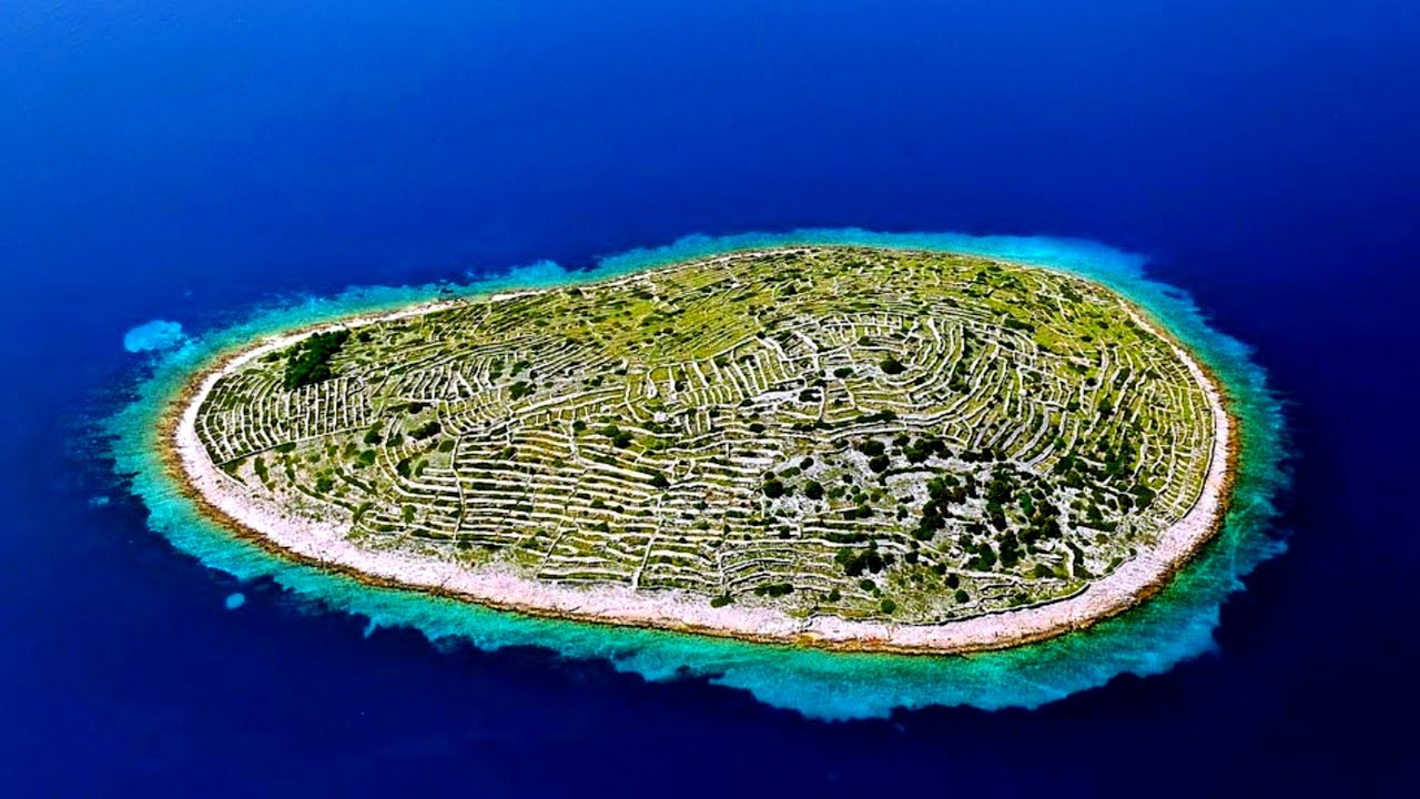
 Baljenac (also known as Bavljenac)…a tiny island in the Adriatic Sea, just off the coast of Croatia, seems to be showing up all over the internet these days. When you first see it, you will be…rather shocked by its appearance, because well, it really looks like a giant fingerprint. My first thought was, “Is that natural, or man-made?” Well, of course, the structures are man-made, but their original intent was not to create a giant fingerprint. These dry-stone walls that make up the web that covers the island, have been there for centuries, and their purpose is very different than how they make the island look from the air.
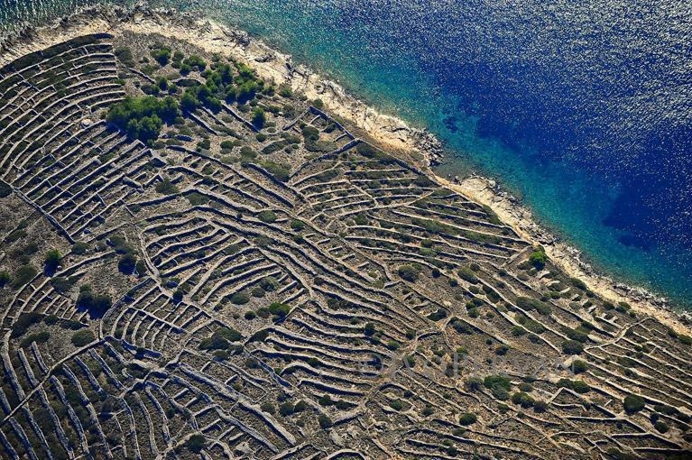
The island is located in the Sibenik archipelago on the Dalmatian coast. The island is quite small…just .75 square miles, and it is completely covered by the web of dry-stone walls. The island’s oval shape along with the web of walls makes it look amazingly like a fingerprint. The long lines of low walls, combined with the oval shape bring about the amazing resemblance. Apparently, these dry-stone walls are not that uncommon in west European nations such as Ireland, England and Scotland, much of Croatia’s countryside. The dry-stone walls hug many of these island nations. Originally, they were used for centuries, to mark boundaries between adjacent agricultural lands. That might make sense, but the walls on Fingerprint Island don’t seem to allow for a very big garden, much less be a separation of agricultural lands. Aside from defining agricultural boundaries, the walls also keep out strong winds known as “Bura” that would make cultivation impossible in exposed locations along the coastline. The walls, however strange and however strange they make the landscape look, served a great purpose, especially since they withstood the test of time.
The walls are unusual because they were built without mortar to hold the stones together. Instead, builders carefully select stones and stack them snug together like puzzle pieces. That seems like a recipe for the collapse of the walls, and yet they have stood in place for centuries. They did have large amounts of rock to work with, because much of Croatia’ coastline is characterized by karst topography…meaning it’s rocky. If 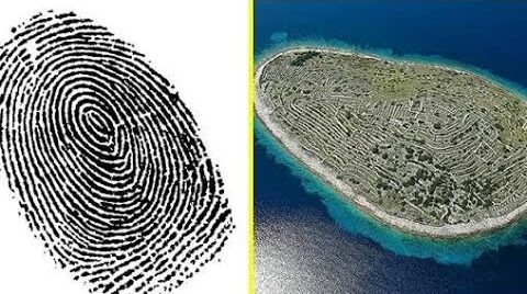 you’re going to grow much on rocky terrain, you have to remove the rocks. So, the farmers painstakingly picked rocks out of the soil by hand and then used the same stones to construct walls around geometric plots. The work, planned to create boundaries, created grids in some cases…and the grids stretched for miles. That seems odd in itself, but in the case of Baljenac (Fingerprint Island), an island just .31 miles long, the walls stretch for 14.29 miles. Because of the length of time the grid has been there, the Croatian government has been pushing the UNESCO to include the island and its dry-stone walls in their World Heritage Sites list.
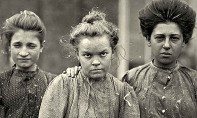 In the toughest of times, the women of the west had to participate in the work force since families had to make ends meet any way they could. But the work was demanding, often outdoors and with physical labor and lots of hours doing agricultural and other large-scale jobs. By the end of the day, they were exhausted…just like their men. It’s not that women aren’t capable of hard work, because they absolutely are. Nevertheless, their bodies aren’t built for the same kind of work as the men…or at least it isn’t as easy as for the men.
During World War I and World War II, when so many men were called to duty, and so many were killed, the workforce at home was dramatically shrinking. So, like they always did, the women stepped up. It’s not that the men weren’t stepping up too, 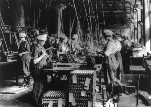 because going to war is most certainly stepping up. Really, everyone was doing a job that was not in their normal wheelhouse. Times were tough and tough times called for tough people. It the war was going to be won, the military had to be supplied with the necessary materials to fight with. Things like ammunition, uniforms, boots, tanks, planes, bombs, guns, and much more were vital; and without the help of the women back home, the men would not have the things they needed to win the war.
The thing about these particular women was that at that time in history, most women were stay-at-home moms, and at that time that really meant cleaning the house, cooking, and caring for the children. These were not times of going to the gym to work out, and the main exercise was the daily chores. Don’t get me wrong, because the chores 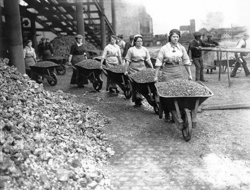 were hard work, and that did keep the women in shape, but they weren’t miners or factory workers. This necessary work was all new to them. The endeavor to bring these women into the workforce was no small undertaking. The had to be trained and trained quickly. There was no time to waste. The women, for their part, jumped at the chance to help their men and the men of the nation. They learned their new jobs quickly and did their jobs efficiently. They were loyal to their men and their country, and they were willing to take on the exhausting jobs they were asked to take on. In fact, I don’t think the wars could have been won, without both parts…the men and the women, and the necessary work they did.
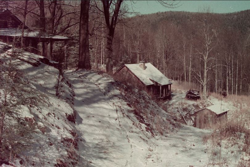
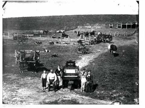
 As America grew, towns popped up in many places, only to dwindle into ghost towns when the expected industry that motivated their beginning, fell through. Lost Cove was one such town. Established just before the Civil War, it was once a thriving agricultural community, but then in the early 20th century, logging replaced farming, and the railroad brought workers. Somehow in the shuffle of changes, Lost Cove found itself off the beaten path, almost hidden in the forest, with no electricity or running water. The little town had to figure out something new, and so, because of the remoteness and because the town lay on the North Carolina/Tennessee border, an equally thriving moonshine industry was born.
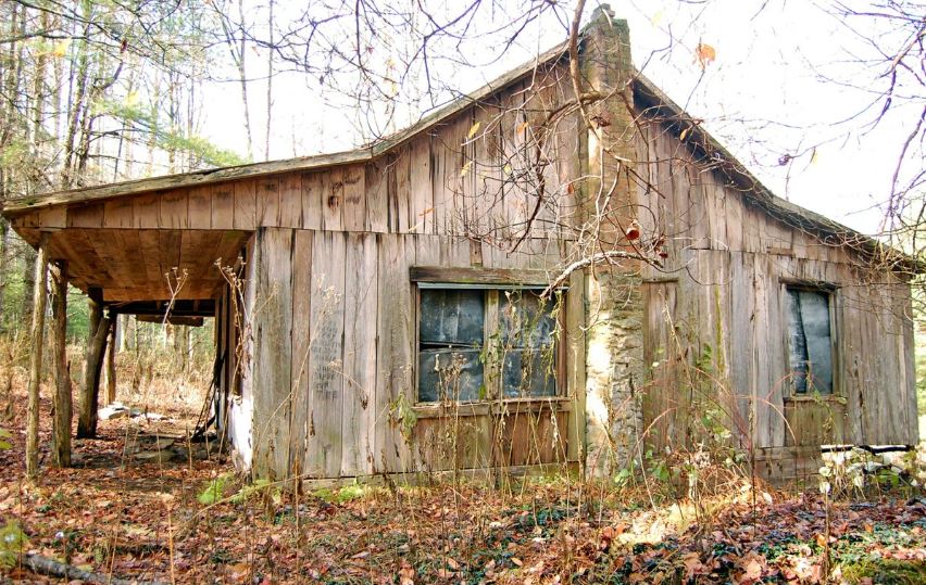
Many people might think that the moonshine industry was all due to prohibition, and that is largely true, but while bootlegging was a crime of opportunity, it was also quite likely to be a crime of necessity. Still, while moonshine could provide a living for the residents, it would never be able to sustain a whole ton for very long. Eventually, the residents of Lost Cove began to move away to laces where they could make a living. The town, now empty, seen fell into disrepair. These days Lost Cove is a graveyard of abandoned homes and crumbling gravestones. Because Lost Cove was on the border, either state could have agreed on jurisdiction to collect tax revenues, but both declined to, thereby creating a haven for bootlegging.
Even with the logging business doing well, the timber eventually thinned and the railroad service that brought passenger trains through the area stopped. With that, the Lost Cove residents became even more isolated. The nearest stores were eight miles away, and they would have to walk for basic supplies, mostly because they didn’t have money for any other form of transportation. Soon the infrastructure deteriorated too, and the rough 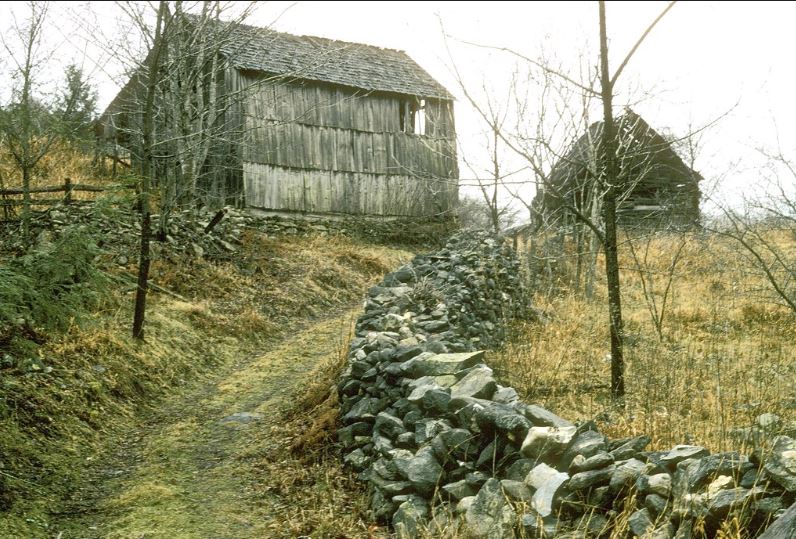
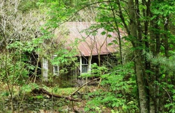 or non-existent roads led to even more shortages. In the end, here was nothing left, but to leave. The last known resident left in 1957. Sadly, in 2007, a fire destroyed most of what still stood in Lost Cove. All that is left now is a few structures, memories, and the history of the area, only seen by the occasional hiker, using trails that remain the only route of access.
 As Americans began to expand to the West, new territories had to be opened for settlement. Of course, this was not always met with approval from the Indian nations who were living there at the time. Nevertheless, the settling of this nation would not be stopped, and while it was handled wrong in many ways, it was inevitable. Nearly two million acres of land in Oklahoma Territory had been preciously deemed unsuitable for white settlement, and so were given to the Native Americans who had been previously removed from their traditional lands to allow for white settlement. The relocations began in 1817. By the 1880s, Indian Territory was home to a variety of tribes, including the Chickasaw, Choctaw, Cherokee, Creek, Cheyenne, Comanche, and Apache.
By the 1890s, with the improvements in agricultural and ranching techniques led some white Americans to realize that the Indian Territory land could be valuable, so they began to pressure the United States government to allow white settlement in the region. In 1889, President Benjamin Harrison agreed, making the first of a long series of authorizations that eventually removed most of Indian Territory from Indian control. To begin the process of white settlement, President Harrison chose to open a 1.9 million acre section of Indian Territory that the government had never assigned to any specific tribe. I suppose it was a way to ease into it without taking land from any specific tribe…initially anyway. However, subsequent openings of sections that 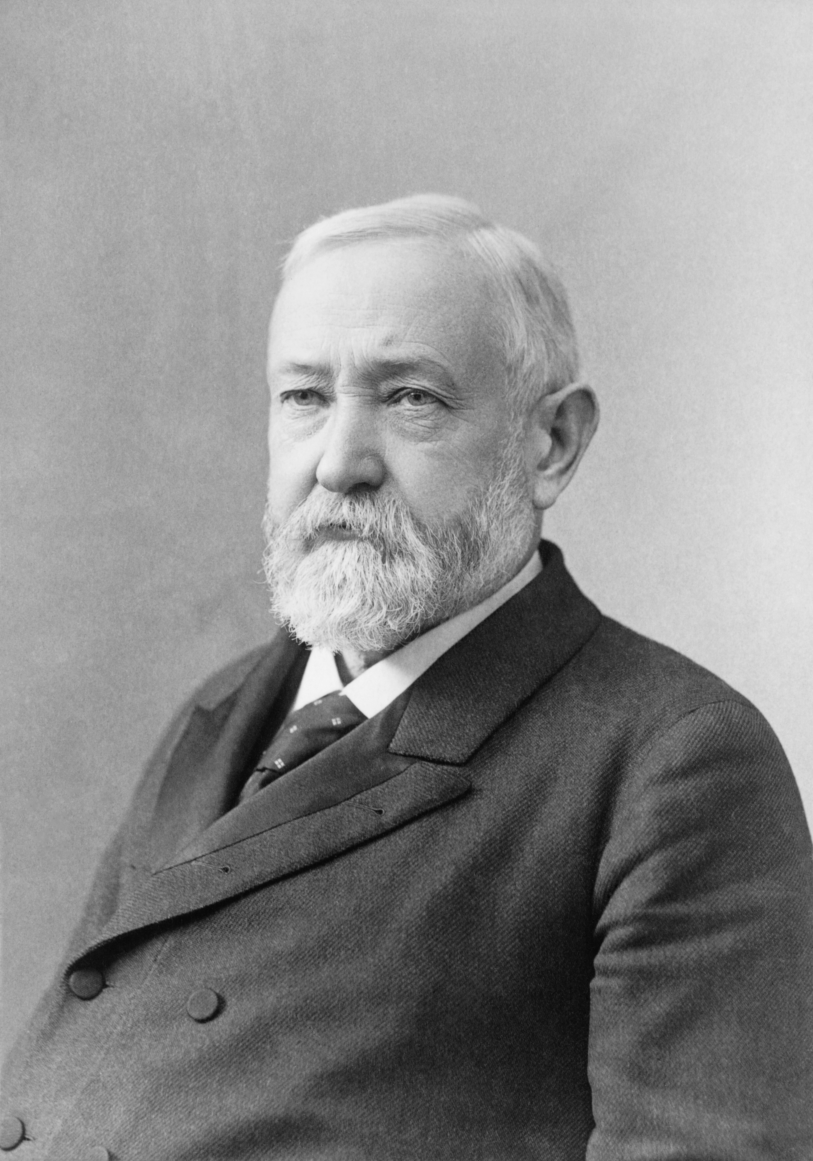 were designated to specific tribes were achieved primarily through the Dawes Severalty Act of 1887, which allowed whites to settle large swaths of land that had previously been designated to specific Indian tribes.
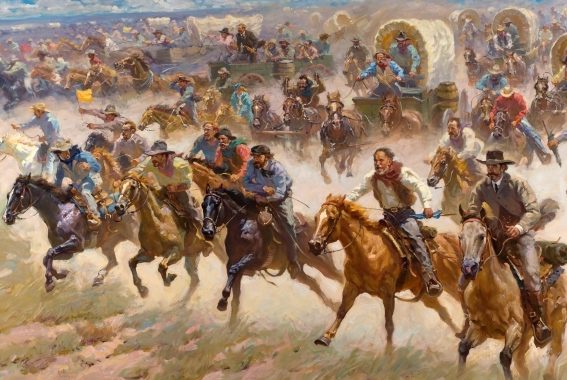
On March 3, 1889, Harrison announced the government would open the 1.9 million-acre tract of Indian Territory for settlement precisely at noon on April 22, 1889. Anyone could join the race for the land, but no one was supposed to jump the gun. With only seven weeks to prepare, the land-hungry Americans quickly began to gather around the borders of the irregular rectangle of territory. They were referred to as “Boomers,” and by the appointed day more than 50,000 hopefuls were living in tent cities on all four sides of the territory. At precisely high noon, thousands of would-be settlers make a mad dash into the newly opened Oklahoma Territory to claim cheap land. I can only imagine the chaos. The events that day at Fort Reno on the western border were typical of the entire process. At 11:50am, soldiers called for everyone to form a line. When the hands of the clock reached noon, the cannon of the fort boomed, and the soldiers signaled the settlers to start. With the crack of hundreds of whips, thousands of Boomers streamed into the territory in wagons, on horseback, and on foot. All told, from 50,000 to 60,000 settlers entered the territory that day. By nightfall, they had staked thousands of claims either on town lots or quarter section farm plots. Towns like Norman, Oklahoma City, Kingfisher, and Guthrie sprang into being almost overnight.
 An extraordinary display of both the pioneer spirit and the American lust for land, the first Oklahoma land rush was also plagued by greed and fraud. Cases involving “Sooners,” who were people who had entered the territory before the legal date and time overloaded courts for years to come. I’m sure that the Indians weren’t pleased either, and I would imagine that there was periodic trouble over the whole process too. The government attempted to improve the operations of subsequent runs by adding more controls, finally adopting a lottery system to designate claims. By 1905, white Americans owned most of the land in Indian Territory. Two years later, the area once known as Indian Territory entered the Union as a part of the new state of Oklahoma.

