History
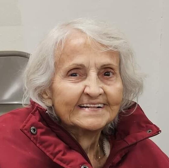
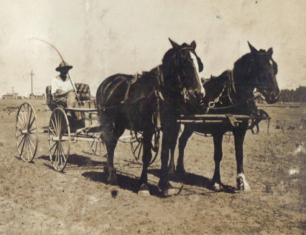
 While visiting my Aunt Sandy Pattan during her stay at Elkhorn Valley Rehabilitation Hospital where she is recuperating from a recent surgery, we were talking about our favorite subject…the Byer-Pattan Family History. The subject turned to the many things her parents, my grandparents, George and Hattie Byer had seen come into being during their lifetimes. Grandpa was born on June 15, 1893, and Grandma was born on February 26, 1909. A sixteen-year age difference wasn’t that uncommon in those days, and many people to this day have a large age difference between husband and wife. Of course, the world when Grandma was born was already quite different than the world when Grandpa was born. The automobile was first invented…officially in 1889, but people really didn’t start owning them until about 1929, so by the time my grandparents were married in 1927, a few people might have owned their own car, but many still didn’t. For those, it was still the horse and buggy days.
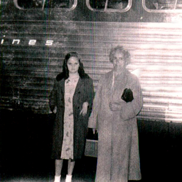
Planes were another thing that the most likely saw come into existence. While they existed at the time my grandmother was born, they did not during my grandfather’s early years. Nevertheless, like automobiles, planes were not something that was commonly in use for the average citizen. They were too expensive and so were only for the very rich or for military use. Most people who needed to travel long distances used the trains in those days, and some very likely still used the horse and buggy travel mode. Of course, truth be told, there 
 are still those who use a horse and buggy today. The Amish and even a few others, but the others are mostly for show, like parades, races, and such. Personally, my husband, Bob and I dearly love the trains. We ride one pretty much every year. I think trains are in my blood. My dad grew up riding them, because his dad worked as a carpenter for the Great Northers Railroad. Because of that, his kids got a free pass to ride…within reason, of course.
Televisions might have been “invented” in the late 1800s, but they were not common in homes until much later. In fact, in 1947 there were only a few thousand televisions in homes in the United States. I suppose that getting programming together could have had something to do with it, but many people thought it was an unnecessary evil, and maybe they had a point. Prior to that time, families would gather around the radio to hear the latest news…especially when it came to the important news of the wars.
Telephones were just as rare. Invented in 1869 by Alexander Graham Bell, although, it was truly a race between him and other competitors. Nevertheless, he was granted the patent. By 1920, about 35% of homes had phones. These days we couldn’t imagine running our lives without a phone, and who needs a home, we carry them in our purses, pockets, backpacks, and even on our wrist. If you don’t have access to your phone, it 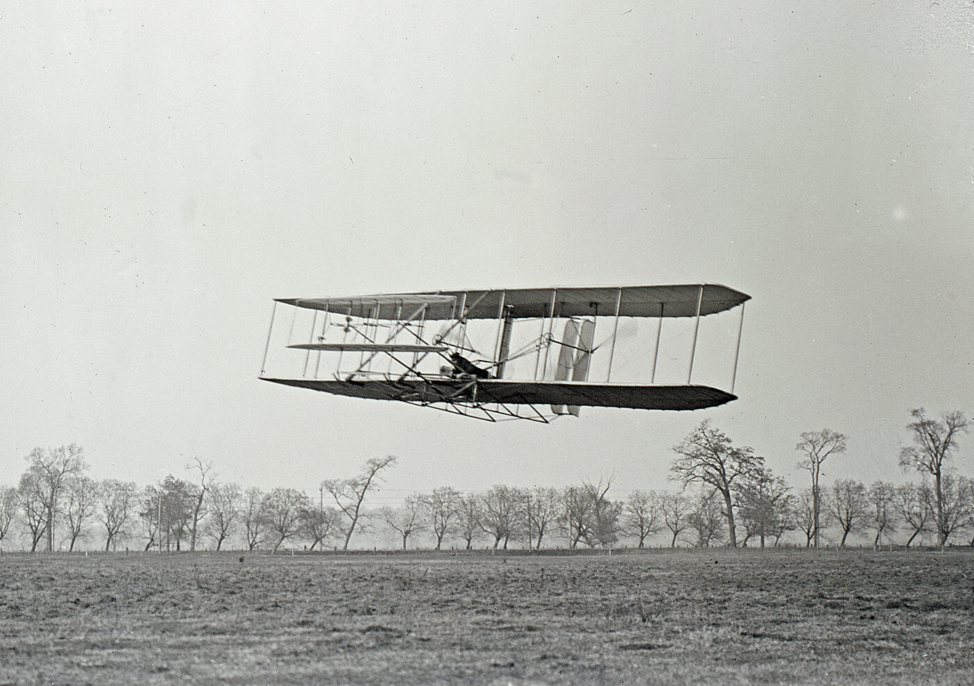
 is entirely your fault…either you forgot it or you let the battery die. Either way…your fault. Aunt Sandy and I agreed that there have also been a lot of changes in our eras, but maybe not quite as drastic as the ones our parents and grandparents saw. I’m quite sure there will be many more changes as time goes on. Space travel, for the common man being one. Wow!! Now, that’s something to think about!!
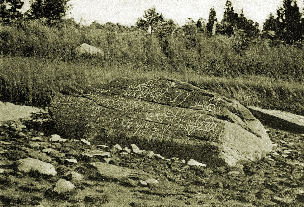
 The Dighton Rock is a 40-ton boulder that was found in the riverbed of the Taunton River at located Berkley, Massachusetts, over 300 years ago. The rock has puzzling petroglyphs on it that have apparently never been able to be deciphered. Dighton Rock is one of the greatest mysteries of Massachusetts. The boulder is slanted and has six sides. It is approximately 5′ high, 9½’ wide, and 11′ long. All of those 300 years, people have wondered about the lines, geometric shapes, drawings, and writing that appear on the rock and who created them. They wanted to figure it out. What did it mean? Who made those markings, so many years ago. No one really knows how long ago the marks were made, only about how long ago it was found.
The rock has been studied by many people over the years. In 1680, English colonist Reverend John Danforth drew a copy of the petroglyphs. That drawing has been preserved in the British Museum, but there are conflicts as to the accuracy of the drawing. Some say the markings aren’t exactly the same as the rock. In something as intricate as petroglyphs, accuracy would be of vital importance. Ten years later, in 1690 Reverend Cotton Mather described the rock in his book, The Wonderful Works of God Commemorated: “Among the other Curiosities of New England, one is that of a mighty Rock, on a perpendicular side whereof by a River, which at High Tide covers part of it, there are very deeply Engraved, no man alive knows How or When about half a score Lines, near Ten Foot Long, and a foot and half broad, filled with strange Characters: which would suggest as odd Thoughts about them that were here before us, as there are odd Shapes in that Elaborate Monument…”
One theory suggests that Indigenous peoples of North America…who were known to have inscribed petroglyphs in rocks (a schematic face on the Dighton Rock is similar to an Indian petroglyph in Eastern Vermont) made the markings. A second theory suggests that Ancient Phoenicians made them was proposed in 1783 by Ezra Stiles in his “Election Sermon” as the “descendants of the sons of Japheth.” Still another theory suggests that the Norse might have made them. That theory was proposed by Carl Christian Rafn in 1837, but it was rejected by archaeologists such as TD Kendrick and Kenneth Feder. Others suggested that the Portuguese may have made them. That was proposed in 1912 by Edmund B Delabarre, who (after seeing Portuguese writing) believed that they then used the rock for their own inscriptions. Delabarre wrote that “markings on the Dighton Rock suggest that Miguel Corte-Real reached New England. Delabarre stated that the markings were abbreviated Latin, and the message, translated into English, reads as follows: “I, Miguel Cortereal, 1511. In this place, by the will of God, I became a chief of the Indians.'” Of his findings, Douglas Hunter wrote in his book “Reconstructing the 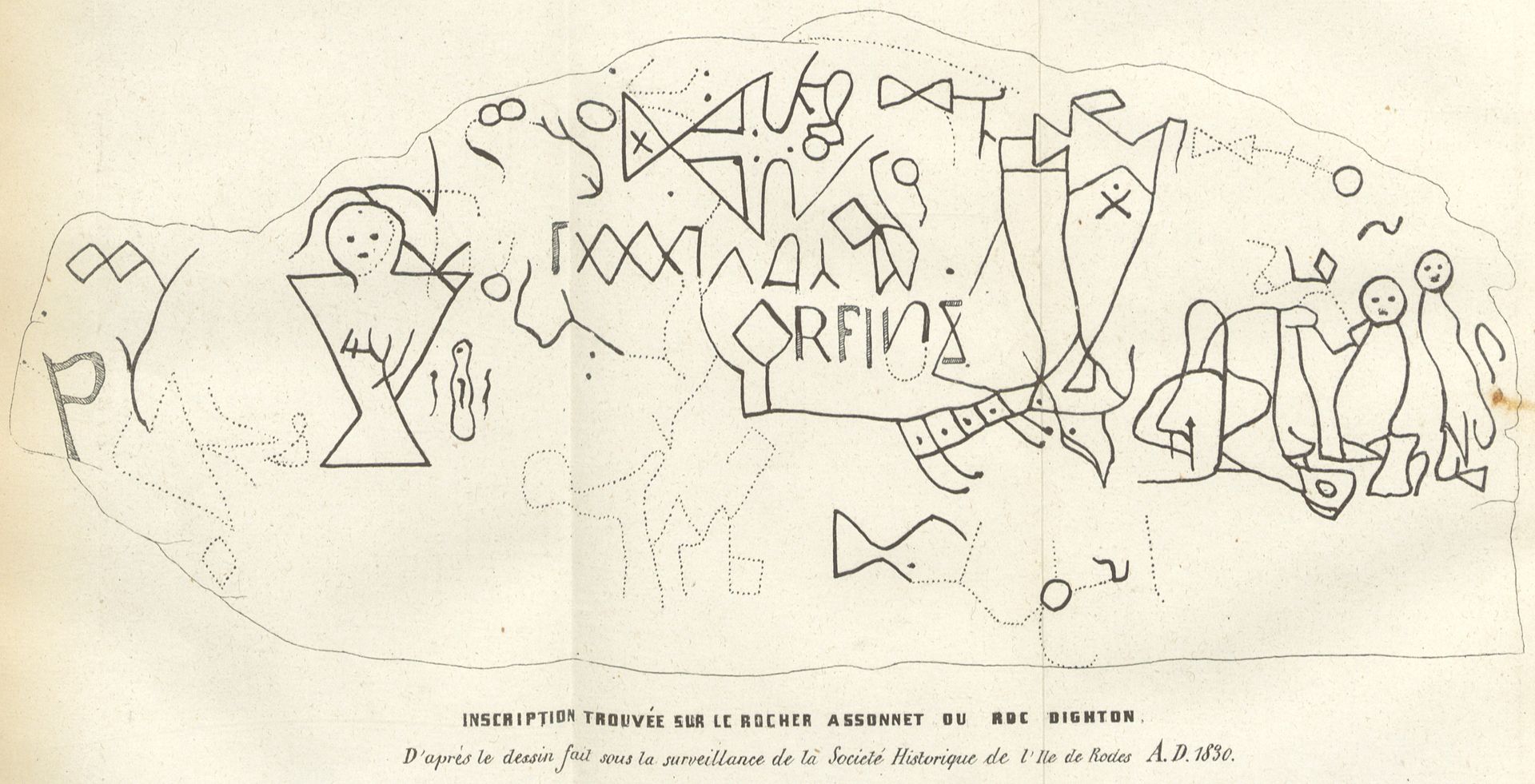
 history of writing about Dighton Rock” provides copious evidence and analysis debunking the Corte-Real origin myth. Lastly, the Chinese have also been suggested as a possible source, proposed by Gavin Menzies in his 2002 book “1421: The Year China Discovered America.” I don’t think we’ll ever know who made them or what they mean.
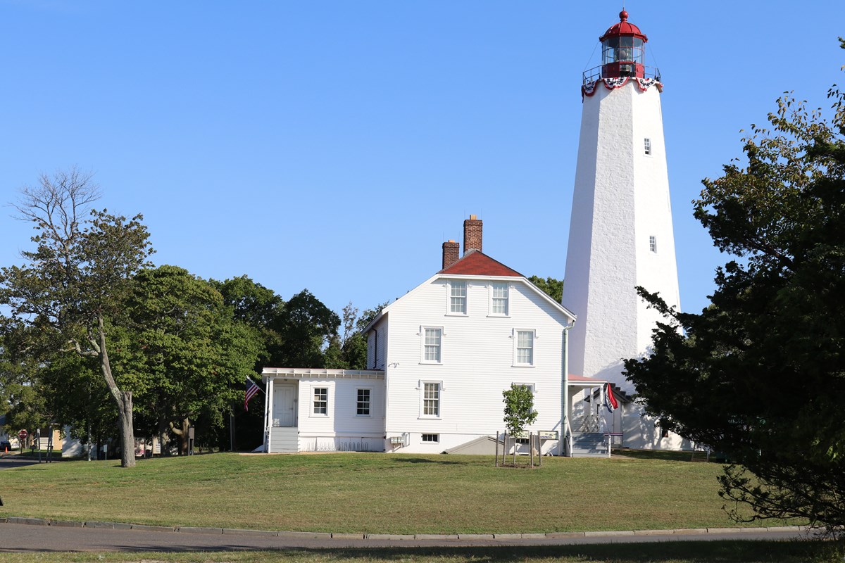 A lighthouse is by definition, a tall building set on the coast with a light in its tower to warn ships of the presence of dangerous rocks or shores. I have long loved lighthouses…their history, the ships they protected, and the place you find them. These days, there might not be as much need for lighthouses, because of GPS, but GPS can fail, computers can crash, and some solar activity can affect GPS too. There are lots of reasons why it can fail, so these days, lighthouses might be considered a…backup plan. You never know when they might be needed, and that is not the time to find out that you don’t have them.
The lighthouse at Sandy Hook, in what is now New Jersey, was put in use on June 11, 1764. It was needed badly, and the Provincial Congress of New York orchestrated two lotteries to raise money for its construction. As with many projects, things moved slowly. The lighthouse was first suggested for Sandy Hook nearly a century before, but it was finally initiated by Colonial Governor Edmund Andros. It finally became a priority 43 New York merchants, lost 20,000 pounds of sterling from shipwrecks in 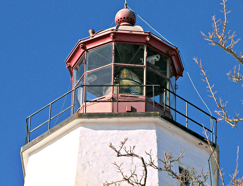 early 1761. Suddenly, it was really important. to protect those ships and their cargo. In the 27 months that the light house at Sandy hook stood, she had protected many ships.
Then, on March 6, 1776, a committee of the New York Provincial Congress instructs Major William Malcolm to dismantle the Sandy Hook lighthouse. The territory was in dispute, and Major Malcolm’s task was to prevent the lighthouse from helping the British to reach New York City. The Congress wanted Malcolm to remove the lens and lamps so that the lighthouse could no longer warn ships of the rocky shore. Major Malcolm succeeded. Colonel George Taylor reported six days later that Malcolm had “given him eight copper lamps, two tackle falls and blocks, and three casks, and a part of a cast of oil from the dismantling of the beacon.” While the removal would most certainly mean the loss of ships and lives, it was deemed collateral damage, even if some of the ships were friendlies.
While the lighthouse removal was a success, it did not keep the British from invading New York. They were soon 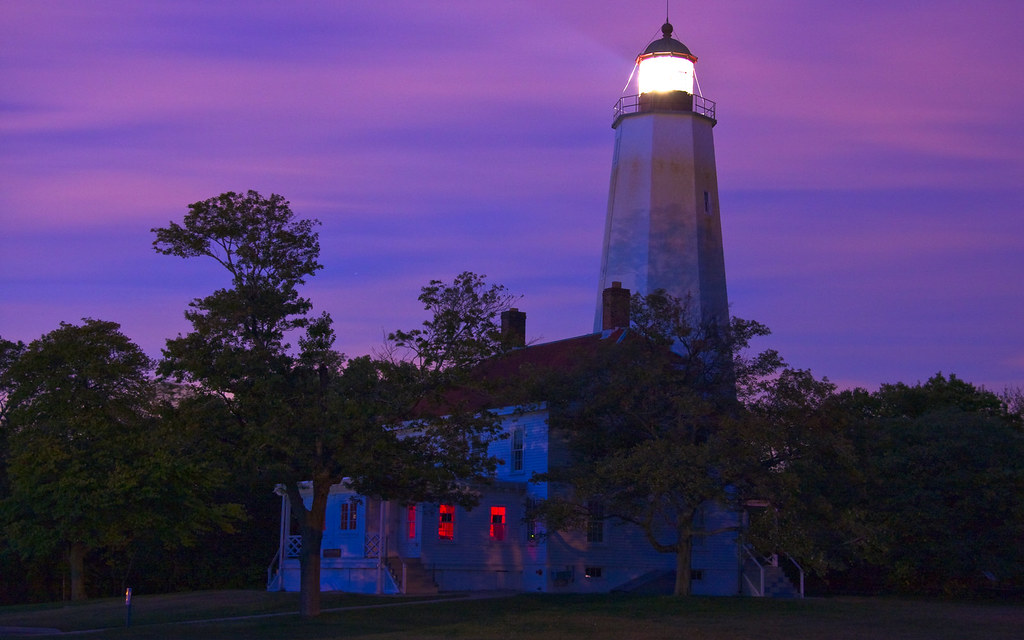 able to put the lighthouse back into service by installing lamps and reflectors. The Patriots attempted to knock the light out again on June 1, 1776, by placing cannon on boats and attempting to blow away the British equipment. They managed some damage before being chased away. The new states of New Jersey and New York bickered over ownership of the lighthouse, until the federal government assumed control of all US lighthouses in 1787. As of 1996, the Sandy Hook lighthouse, the oldest original lighthouse in the United States, passed into the jurisdiction of the National Park Service. I’m glad it survived all that turmoil. It would be sad if it was lost forever.
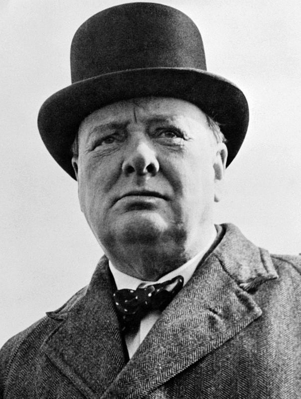
 “Who was Winston Churchill?” It’s not a question you often hear, because Winston Churchill had a presence. His features were distinct, but he was not a big man. Churchill stood 5’6½” tall and weighed 187 pounds. He was maybe 35 pounds overweight, but not in bad health, especially considering he smoked as many as ten cigars a day, and when you consider that he lived to be 90 years old, it would seem that none of the normal “risk factors” applied to Winston Churchill. He dealt with daily stress, poor eating habits, excess weight, and smoking, but outlived many people in this era or that. How people felt about Winston Churchill, depended on which side of the subject in question they were on. When he made up his mind on a matter, he rarely changed his mind, and he didn’t back down.
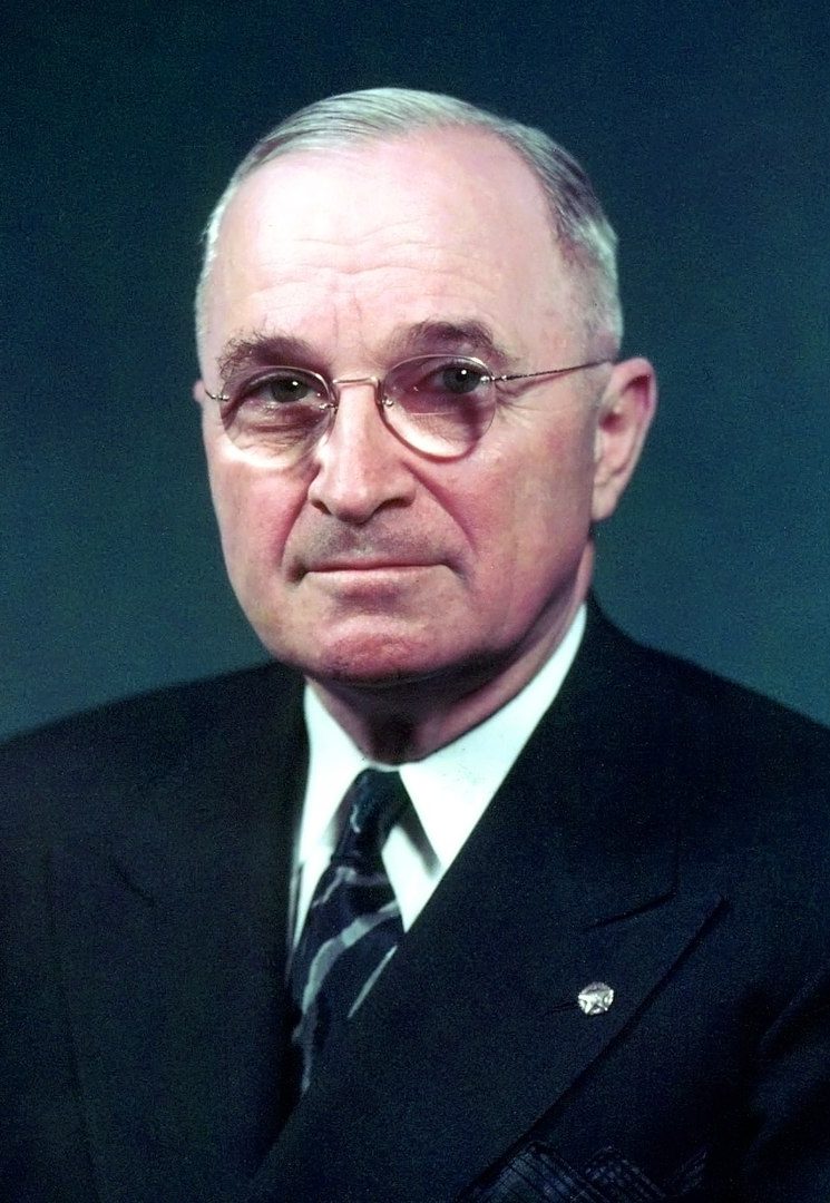
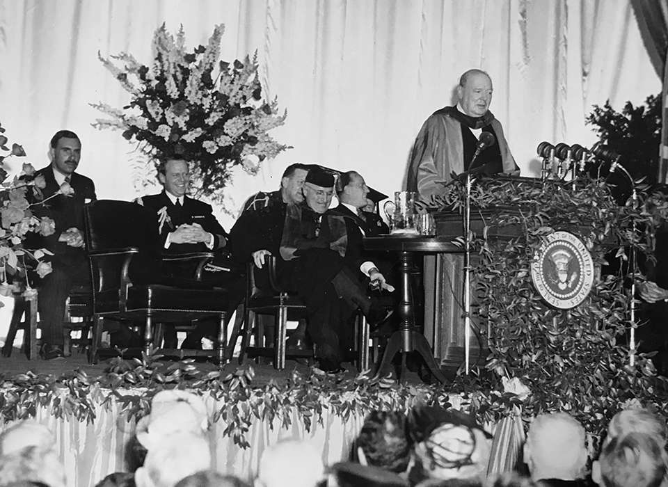
He was responsible for one of the most famous speeches of the Cold War period. It was a speech in which former British Prime Minister Winston Churchill condemned the Soviet Union’s policies in Europe and declared, “From Stettin in the Baltic to Trieste in the Adriatic, an iron curtain has descended across the continent.” Churchill’s Cold War speech is one of the “opening volleys” announcing the beginning of the Cold War. When he was defeated for re-election as prime minister in 1945, he was invited to Westminster College in Fulton, Missouri, which is where he gave this speech. President Harry S Truman joined Churchill on the platform and listened intently to his speech. Expressing praise for the United States, Churchill declared that the United States stood “at the pinnacle of world power.” England and the United States have long had a “friendly, but competitive relationship,” and it would soon become quite clear that a primary purpose of his talk was to argue for an even closer “special relationship” between the United States and Great Britain…the two great powers of the “English-speaking world.” But, would it be in the best interest of the United States to agree?
World War II had ended, and as in any post war situation, things were still pretty chaotic. Nevertheless, it was necessary to set policies, and to organize the losing countries so that things didn’t escalate out of control 
 again…not an easy task. The Soviet Union was well known for its expansionistic policies and was unlikely to stop trying to take over its neighbors without some kind of intervention. In addition to the “iron curtain” that had descended across Eastern Europe, Churchill spoke of “communist fifth columns” that were operating throughout western and southern Europe. Churchill compared the Soviet Union to disastrous consequences of the appeasement of Hitler prior to World War II, saying that in dealing with the Soviets there was “nothing which they admire so much as strength, and there is nothing for which they have less respect than for military weakness.” Therefore, without intervention, they would quickly get back to the same disastrous practices they used before, and the war would have to fought all over again.
The speech was well received by Truman and many other US officials. Everyone knew the truth, and somebody simply had to come right out and say it. They had decided that because the Soviet Union was determined to expand, only a tough stance on a united front would deter the Russians. Churchill’s “iron curtain” phrase immediately entered the official vocabulary of the Cold War. It was a term everyone knew, and it perfectly described the problem. Of course, agreeing with Churchill, didn’t necessarily mean that the US officials enthusiastic about Churchill’s call for a “special relationship” between the United States and Great Britain. They weren’t concerned that Great Britain would again try to have some influence over the United States, but rather they were well aware that Britain’s power was weakening, and the US had no intention of being used as pawns to help support the crumbling British empire.
Of course, the Russian leader Joseph Stalin had a very different view of the speech, saying that it was “war 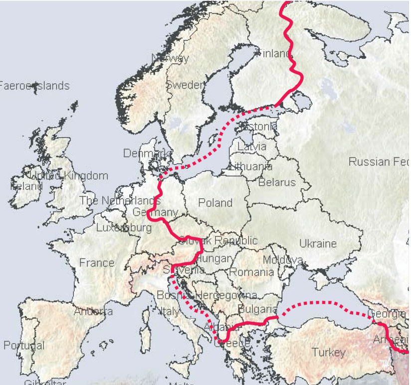
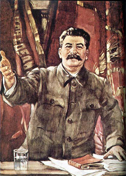 mongering” and referred to Churchill’s comments about the “English-speaking world” as imperialist “racism.” The British, Americans, and Russians, all of whom were allies against Hitler less than a year before the speech, were now drawing the battle lines of the Cold War. It didn’t take long for the similarities between Hitler and the Soviet Union to become glaringly clear, and they had to be stopped. I don’t know why dictators feel the need to enslave other people. The “Iron Curtain” would “come down” like all other forms of tyranny must eventually do, but unfortunately, a lot of lives are lost before victory is achieved.
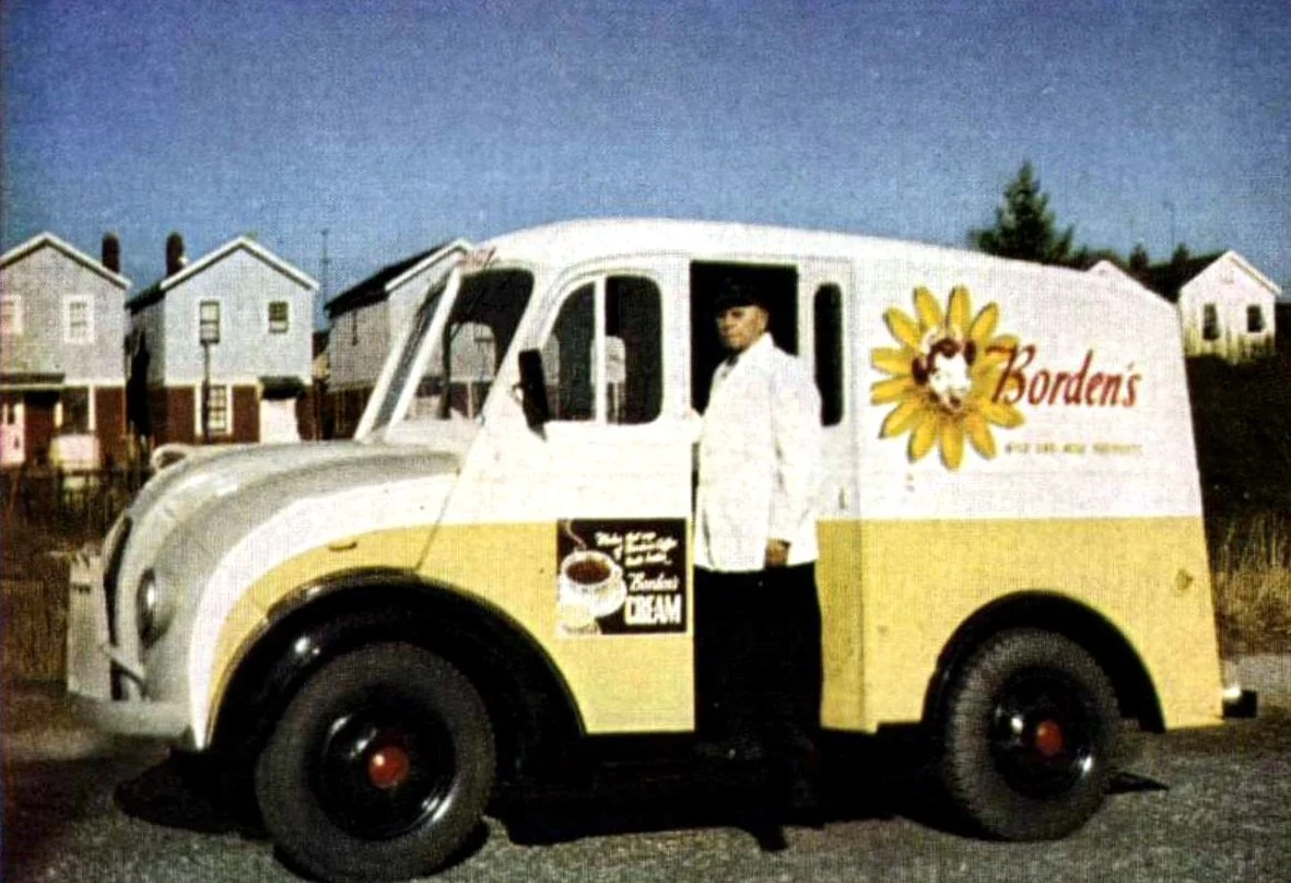
 In the 1950s, most people got their milk delivered early in every morning or sometimes every few mornings. If they were one of the fortunate few, they might also have eggs delivered. That was just how it was done back then. Almost like the summertime ice cream truck many of us remember from our childhood years, you could see the milkman all over town. It was a totally separate business. Milk was not found in the grocery stores, but rather came directly from the creamery. In some ways, I think it is sad that those days are gone now. When I was a little girl…actually a baby, my dad, Allen Spencer worked in a creamery in Superior, Wisconsin. I don’t remember it, of course, but I always found it interesting. My sister, Cheryl Masterson remembers it though. She told me that Dad “worked at the creamery. He loaded and delivered tankers of milk to the places that bottled the milk. He washed and cleaned out his own tank after the deliveries, too. I remember being there sometimes at night when they sprayed them out. That was at Twin Port Dairy.”
These days the idea of the milkman and milk delivery are long since behind us, but the idea of delivery is not…it 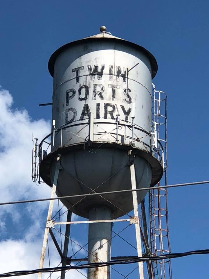
 has just been revamped. When Covid-19 struck, and people were told to stay home (except for essential workers), delivery was revamped. Suddenly, people who were supposed to stay home found themselves needing things, so the only available solution was delivery. People were having food delivered, groceries delivered, even alcohol became a delivery item. Of course, companies like Amazon already existed, and delivered many items to people who didn’t want to go shop, or who wanted to save money on things. Now, suddenly the post office, UPS, and FedEx were delivering many essential items to people.
After Covid faded into the past, the delivery system, somehow didn’t. People still have many things delivered. Many grocery stores also have pick up services, making people their own delivery driver. My daughter, Amy Royce and granddaughter, Shai Royce haven’t shopped for a week’s worth of groceries since Covid. My sister, Cheryl hasn’t either. They put in their orders, and they pick up their groceries the next day. My other daughter, 
 Corrie Petersen and her husband, Kevin have theirs delivered to their house. People are so busy these days, that convenience is the key to a peaceful life. Whenever we go out to breakfast, we see delivery drivers picking up to go orders for delivery to their clients. People just love the convenience of having their food delivered while they stay home in their jammies, I guess. I can understand that, but we still like to go in and shop for our own groceries.
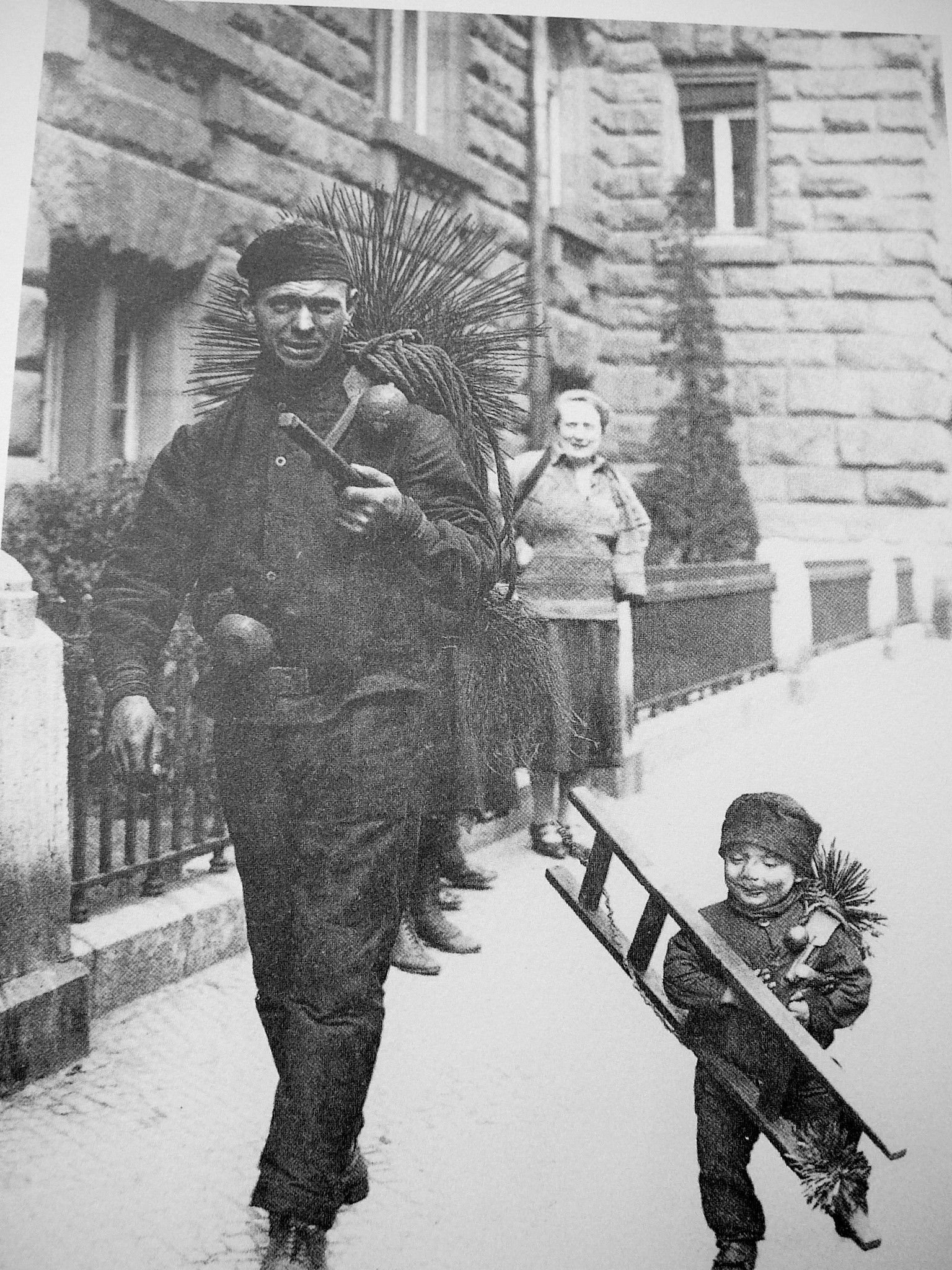
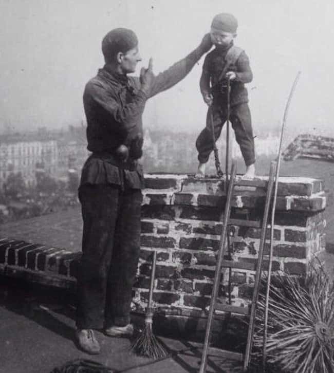 Perhaps one of the most questionable of all professions undertaken by children in the past was that of chimney sweeping. Not only were children exploited in this job, mostly because of their small stature, but since proper safety measures were not taken in those days, the children in those jobs had health problems for the rest of their lives, and very likely they died young. The use of children as chimney sweeps began in the late 1600s in England, after the Great Fire of London, which gutted the city. At that time, building codes changed, requiring chimneys to be much narrower than they were previously. The idea was to keep more of the sparks in than out.
The new design brought with it a bigger problem…keeping the chimneys free of obstruction, which became more of a challenge and a priority. Amazingly, instead of someone inventing a tool for this purpose, children were employed as human chimney sweeps. Their small stature allowed them to go inside the chimneys and manually sweep away the soot. Thus practice went on for over 200 years, in spite of the deplorable conditions the children lived in, the horrible health effects they suffered, and the many injuries and fatalities resulting from related work hazards.
One former chimney sweep, James Seaward was interviewed in December 1909, by the Toronto Saturday Night, a Canadian publication. Seaward was living in Wokingham, where he had just been named alderman of the town’s Borough Council. Seaward was one of the fortunate few that were still alive after working as a chimney sweep for 58 years. He started when he was just six. Seaward tells how he “was only six years old when I went up my first chimney. I was an orphan and I fell into the hands of a chimney sweep, and a cruel master he was. I have known what it was to have straw lighted under me and pins stuck into the soles of my feet to force me up a chimney; and I have known, too, what it was to come down covered with blood and soot after climbing with my knees and elbows. No one knows the terrible cruelty inflicted on boys in those days. 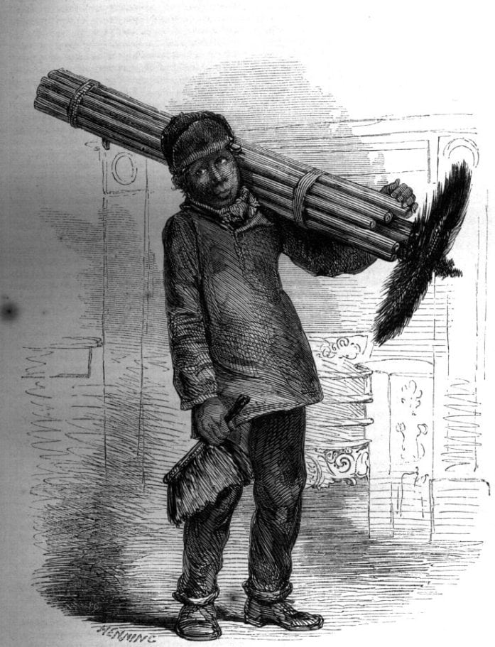
 They used to be steeped in strong brine to harden their flesh. In my own case soda was used. Sometimes I used to have to stay up a difficult chimney five or six hours at a stretch.”
Somehow, Seaward managed to survive, and to actually prosper, even is such deplorable conditions. Thankfully, such cruelty was outlawed during the nineteenth century, with laws introduced regarding child labor. Those laws didn’t address chimney sweeps specifically, but rather child labor in general. The things that were allowed in the past concerning child labor were just awful, and orphans were specifically targeted, because they had little protections over their lives. They were often “adopted” out, but their “new parents” sometimes just wanted slave labor.
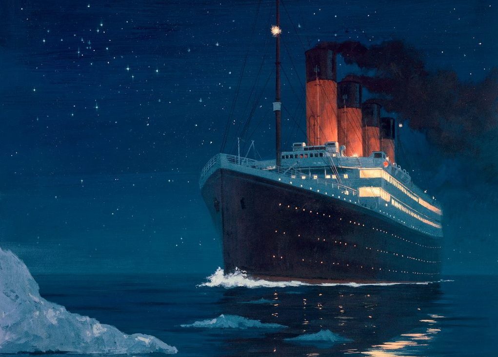
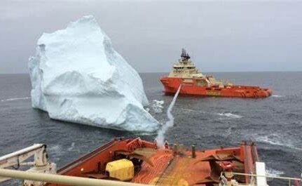
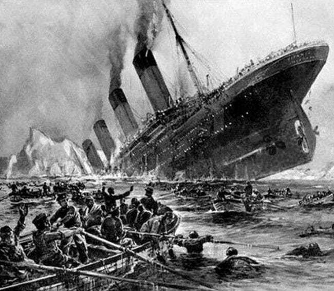 Following the Titanic disaster, a strange kind of job was formed…that of an iceberg mover. This was something I had never heard of, and it seems rather strange. I am aware that icebergs are chucks of ice, and obviously that they float, but to have the job of actually keeping track of an iceberg’s location so that you can go out to move it out of the shipping lanes is a really odd job, if you ask me. Still, the icebergs floating in the oceans, were a serious danger to the ships. Even if other ships were in the area and had seen the icebergs, that doesn’t mean other ships couldn’t fall prey to the icebergs. Many of those ships shut down their radios overnight…the most dangerous time for icebergs.
The job of the iceberg movers was to keep track of the icebergs and if they moved into the shipping lanes, to go in and move them to a different location. Now, that makes me wonder how heavy the icebergs were, and how hard it would be to move them. I also wonder how dangerous it would be, since icebergs have an uncanny knack for flipping over. Of course, iceberg movers are in a boat. Still, it’s hard to say what things can go wrong when an iceberg flips over. I really don’t think this would be a job I would want.
It seems like they might have had trouble hiring people to do this job, or maybe they just needed a more stable crew of men for the job. Whatever the case may be, The International Ice Patrol (IIP), was founded a year later. The IIP is operated by the US Coast Guard. The IIP tracks the location of icebergs and provides safe routes around them. If an iceberg is in a particularly unsafe area, it might become necessary to move it. Then, the iceberg will be towed out of the area. There is no way that they will be able to stop shipwrecks from 
 happening, but if we can remove the dangers created by icebergs, maybe we will see a few less shipwrecks in the future. Since Titanic, there have been five ship that went down after hitting an iceberg. Lives were lost in the first two following Titanic, but in the last three, everyone was saved. The last one was in 2007.
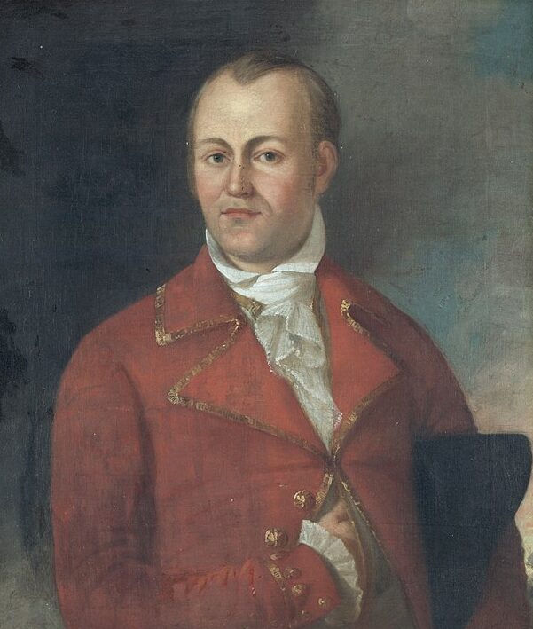
 René-Auguste Chouteau Jr, who was best known as Auguste Chouteau, was the founder of Saint Louis, Missouri. While being a founder of a city is not necessarily such a strange thing, the way in which it came about is not so common. He was the only child of Marie-Thérèse (nee Bourgeois) and René Chouteau, born in either September 7th of either 1749 or 1750. René purportedly abused Marie-Thérèse, and abandoned her and René, so she returned to her pre-matrimonial home. She later remarried. In 1764, when Auguste was still a young man of just 13 years, his stepfather, Pierre Liguest sent him up the Missouri River from Fort Chartres, Illinois. Auguste was the leader of a company of 30 men. His mission was to select a site for a trading post. His stepfather must have considered the young man to be quite intelligent to put him in charge of such an enormous undertaking. Auguste didn’t let his stepfather down either. He chose a place that was not only perfect for the trading post, but would later become a great American city…Saint Louis, Missouri. After his stepfather’s death in 1778, Auguste succeeded him in the business and later formed a partnership with John Jacob Astor. Together they formed the American Fur Company. Auguste was 29 years old.
Chouteau married Marie Therese, the daughter of Jean-Gabriel Cerré, on September 21, 1786, at the Basilica of Saint Louis, King of France, which was a vertical-log church…long since replaced with the current church on the site. The apparently happy marriage united members of the two leading Saint Louis families. They were renowned for their hospitality, which helped strengthen his political position in the city and region. Together they had seven children…Auguste Aristide, Gabriel, Marie Thérèse Eulalie, Henry, Edward, Louise, and Emilie.
Auguste was commissioned colonel of the militia in 1808. His political career began in 1815 when he was appointed one of the commissioners to make treaties with the Indians who had fought on the British side in the War of 1812. The other two commissioners were Ninian Edwards and William Clark. I don’t suppose this would be a big step into politics, but it was an office, and the field of politics seems to take off from a smaller office. 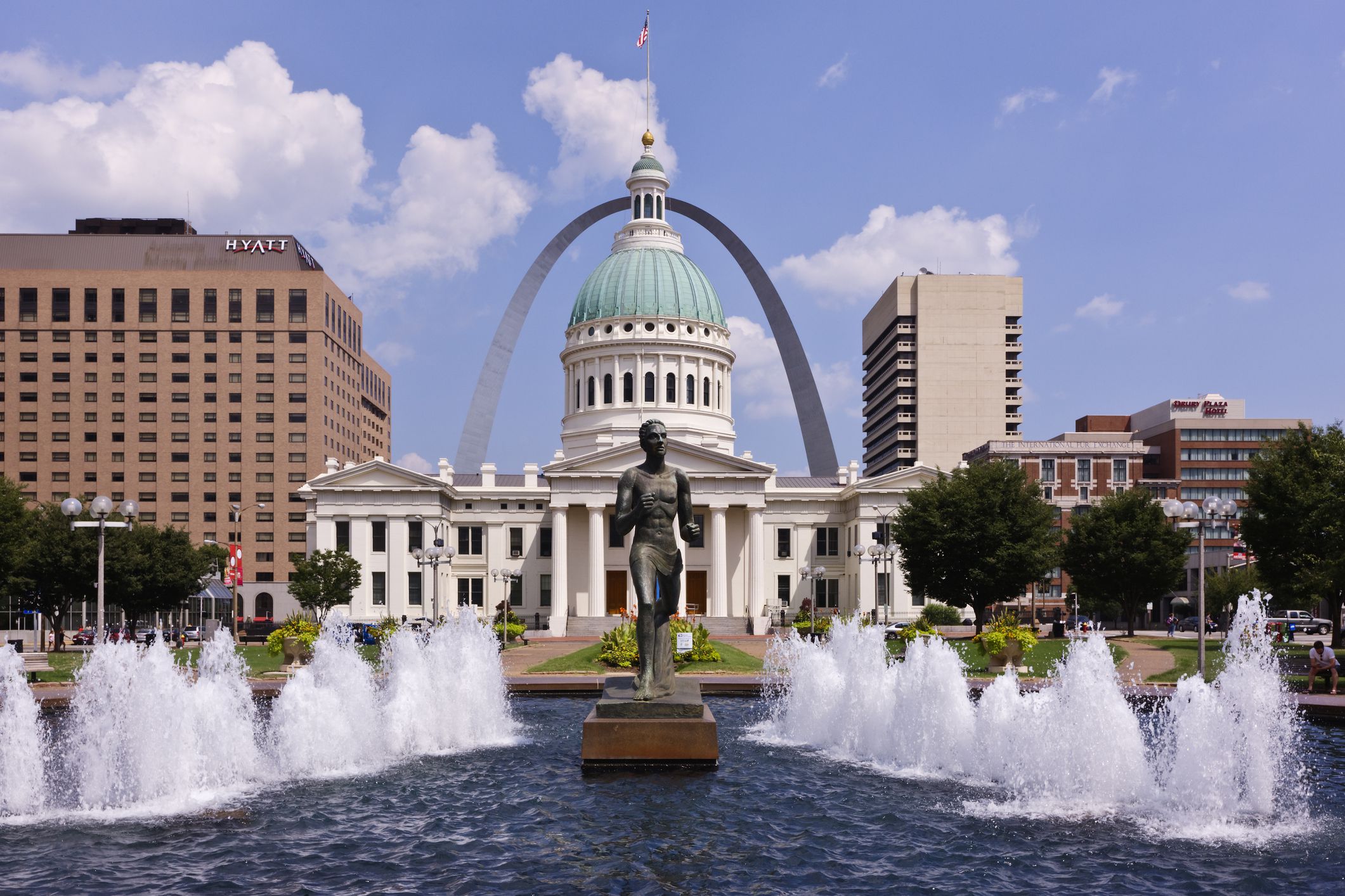
 In Saint Louis, he served as Justice of the Peace and as Judge of the Court of Common Pleas. He was also the first president of the Bank of Missouri, as well as several other important positions. Auguste made it his policy when dealing with the Indians, to treat them fairly. Because of that, he enjoyed their confidence and friendship until his death, which occurred on February 24, 1829.
 When you think about the Civil War, you think of battles being fought back east…right? For the most part, it was. When the war began, there were 34 states, but by the end, there were 36 states. Of course, some of the Southern states, eleven to be exact, wanted to secede and form their own country. That was partly what the war was about. The Southern states wanted to keep slavery, and the Northern states did not, and because they could not agree, eleven states chose to secede, and the rest fought to keep our nation together.
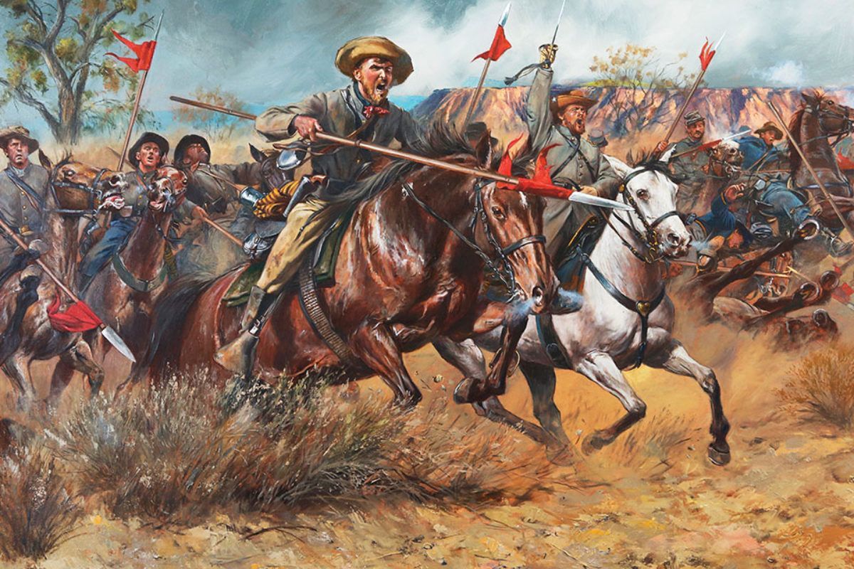
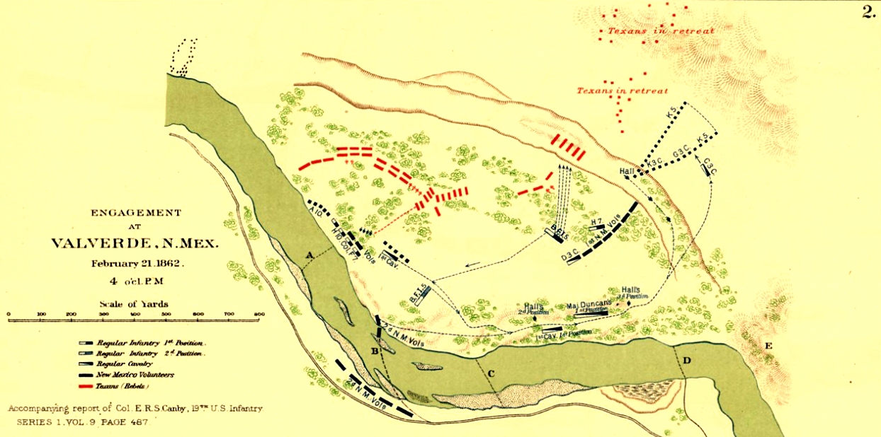
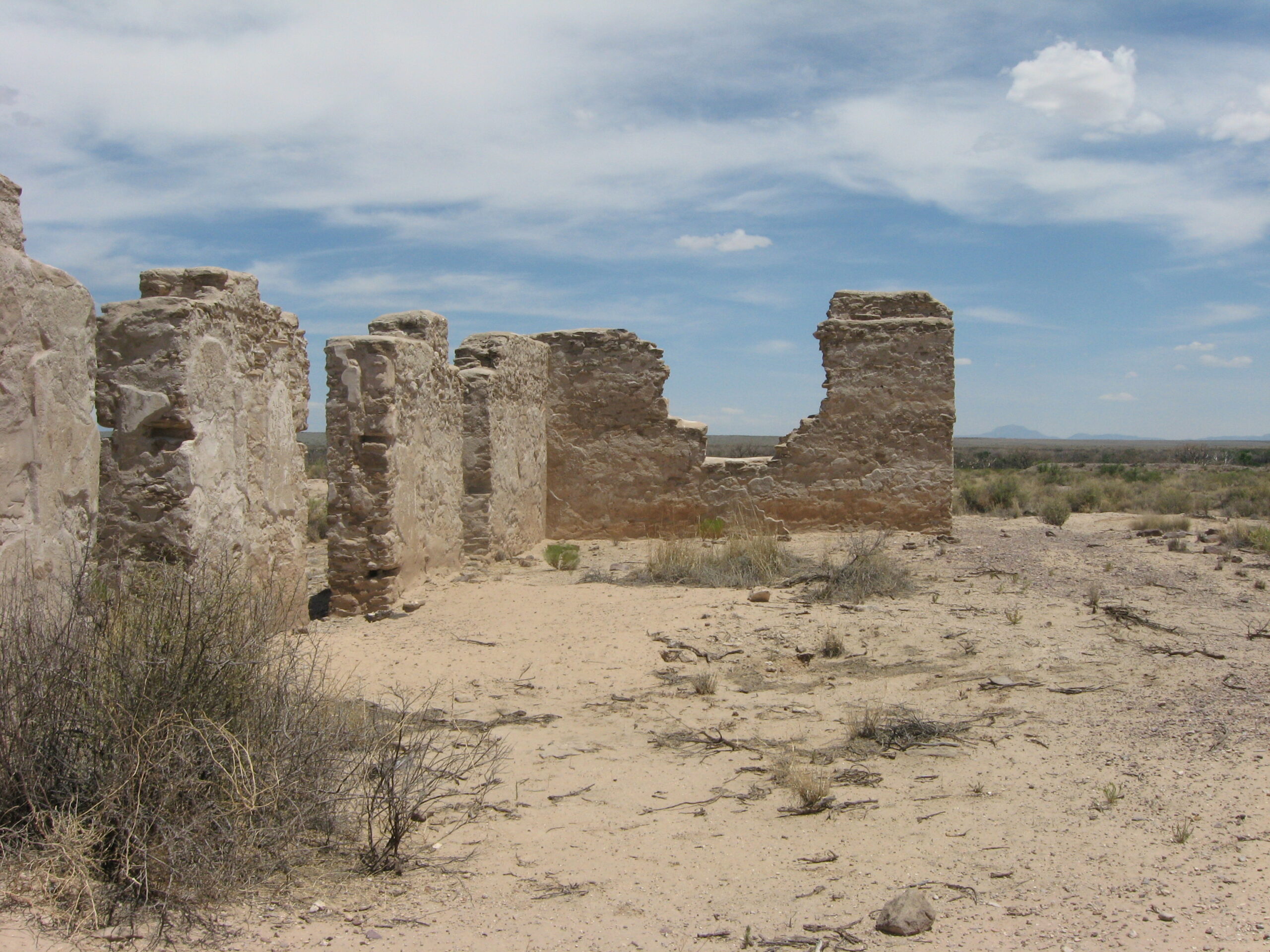
Some of the battles were fought, however on the far western front. The first of those battles, was on February 21, 1862. In the Battle of Valverde, Confederate troops under General Henry Hopkins Sibley attacked Union troops commanded by Colonel Edward R S Canby near Fort Craig in the New Mexico Territory. This first major engagement of the Civil War in the far West, produced heavy casualties but ended with no decisive result. Of course, the battle was part of the broader movement by the Confederates to capture New Mexico and other parts of the West. The point was to secure territory that the Rebels thought was rightfully theirs, because it was part of the southern territories of the United States. This area had been denied them by political compromises made before the Civil War, which they felt was wrong. 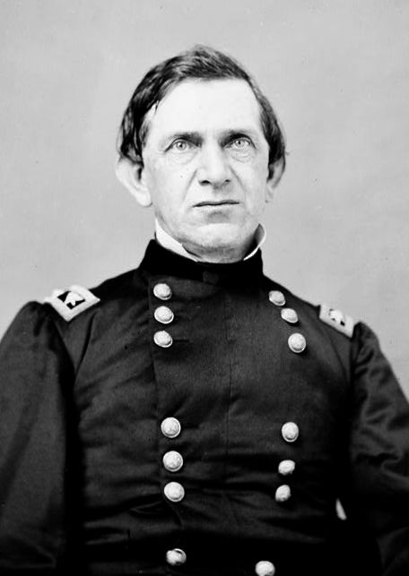
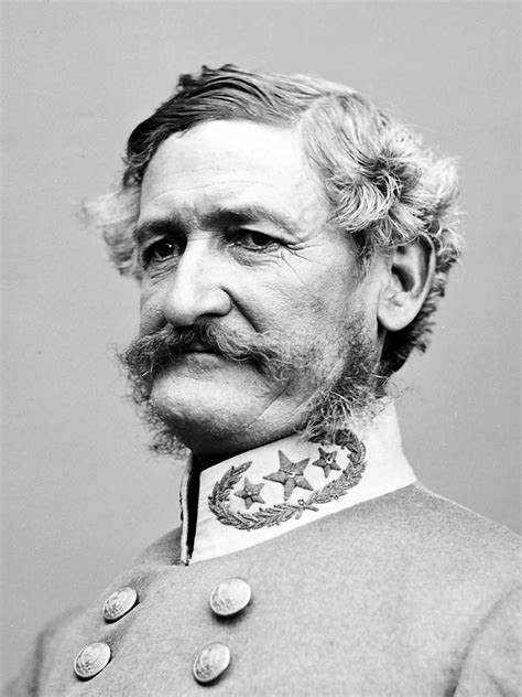
By this time, the Confederacy was quickly going broke, and they wanted to use Western mines to fill its treasury. The Rebel troops moved from San Antonio, into southern New Mexico, which at that time included Arizona, and captured the towns of Mesilla and Tucson. Sibley, with 3,000 troops, now moved north against the Federal stronghold at Fort Craig on the Rio Grande. Canby was determined to make sure the Confederates didn’t lay siege to Fort Craig. Canby knew that the Rebels were running low on supplies, and they wouldn’t last much longer. He knew that Sibley really did not have sufficiently heavy artillery to attack the fort, so when Sibley arrived near Fort Craig on February 15, he ordered his men to swing east of the fort, cross the Rio Grande, and capture the Valverde fords of the Rio Grande. He hoped to cut off Canby’s communication and force the Yankees out into the open, thereby giving the Rebels the upper hand.
For Sibley’s Rebels, things at the fords didn’t initially go as planned. Five miles north of Fort Craig, a Union detachment attacked part of the Confederate force. The Yankees pinned the Texan Rebels in a ravine and were on the verge of routing them when more of Sibley’s men arrived and turned the tide. Sibley’s second in command, Colonel Tom Green, who was filling in for Sibley, who was ill, made a bold counterattack against the Union left flank. The Yankees retreated, heading back to Fort Craig. Sibley’s men didn’t take Fort Craig either.
During the Battle of Valverde, out of 3,100 men, the Union suffered 68 killed, 160 wounded, and 35 missing. 
 The Confederates suffered 31 killed, 154 wounded, and 1 missing out of 2,600 troops. The battle was indeed bloody, but none of their objectives were accomplished, so it was virtually an indecisive battle. From Fort Craig, Sibley’s men continued up the Rio Grande winning battle after battle. Nevertheless, after capturing Albuquerque and Santa Fe, they were stopped at the Battle of Glorieta Pass on March 28, 1862.
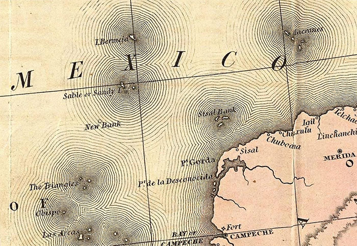
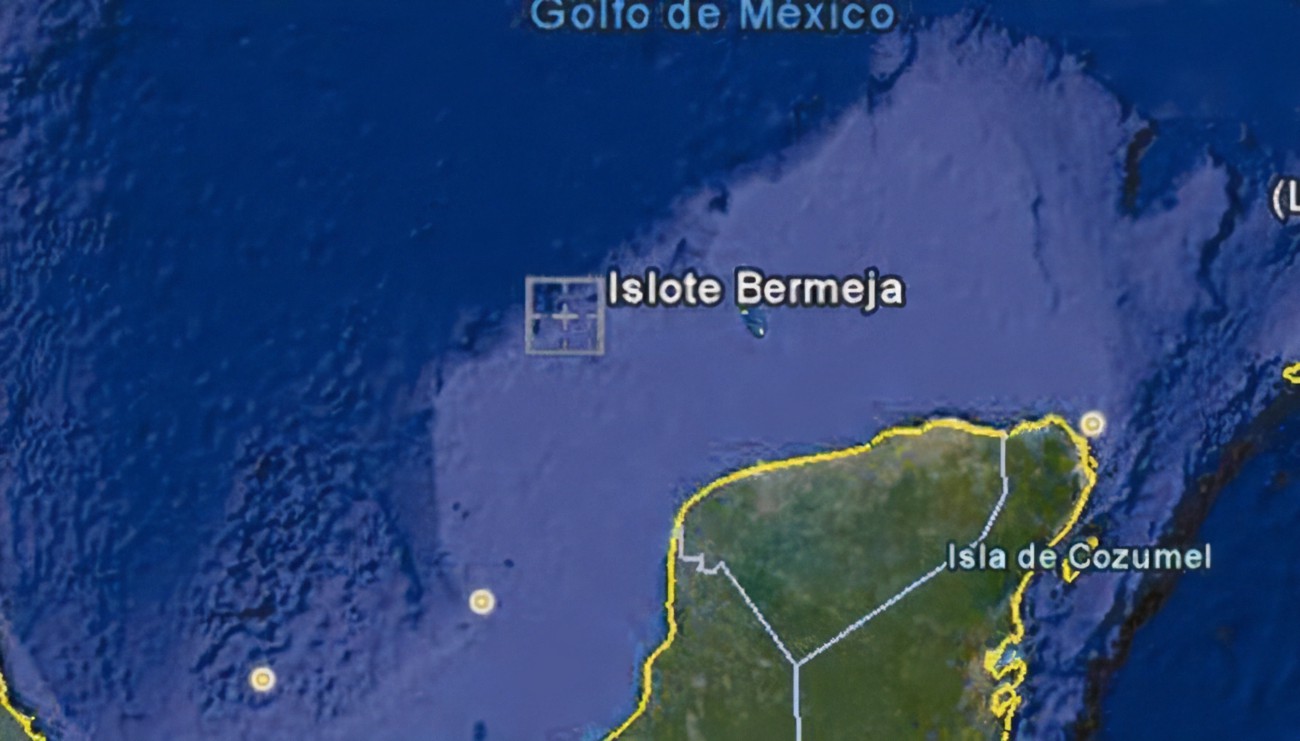
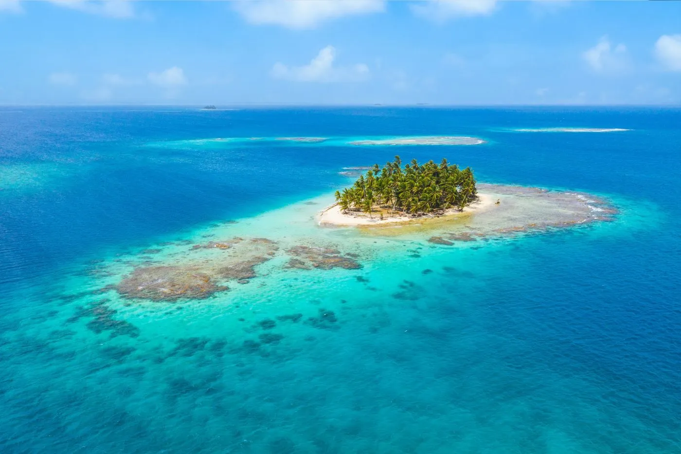 For centuries there the maps of Mexico showed an island called Bermeja located off the north coast of the Yucatán Peninsula. It wasn’t a big island, but it was there. Then, suddenly, it wasn’t there. Now…islands don’t just disappear, so was it there, or wasn’t it, and if it was, where did it go? These days, it’s known as a phantom island. What’s interesting about this island is that a search for it found nothing that could have been called an island. While it is strange that an island was on a map and then wasn’t, I began to wonder why it mattered. There was a reason…oil rights. When a question arose concerning oil rights in the Gulf of Mexico, where the island was concerned, research started when someone pointed out that the island has no real boundaries, and therefore, no rights to oil in the Gulf of Mexico. So, authorities started looking for this piece of land, but they found only water. I’m sure that settled the question of oil rights, but it doesn’t explain whether or not the island ever existed, or if it was just an error on the old maps.
Of course, no pictures of the island are known to exist. All we know is that one century, it’s sitting pretty at 22°33′ N, 91°22 E in the Gulf of Mexico and the next, it’s vanished, confounding maritime investigations and aerial surveys alike. While it may seem to many people as no big deal, the Mexican people want to know where it went. It wasn’t inhabited, so you might wonder why it is so important to know if it did and if so, where it went. The thing is that while it wouldn’t be like the island of Jamaica went missing, it still changes what the Mexican people thought they knew about their world. For some people, that is akin to having your computer have a virus, and you can’t seem to get rid of it. Ok, maybe that is extreme, but in a techy world, that would be a good comparison.
Bermeja was a common fixture on maps drawn by Spanish explorers back in the 16th and 17th centuries. Strangely, its location sometimes varied slightly and sometimes its name appeared as Vermeja, but its existence was not in question at that time. In the 18th century, however, the island’s cartographic presence started faltering, before it eventually dropped off the horizon altogether. Its last mapped appearance dates back to the 1921 edition of the Geographic Atlas of the Mexican Republic. So, what happened to it? If you ask me it eroded away, but that is just my opinion. There are many theories regarding Bermeja’s mysterious fate. Some say that “global warming” caused the island to succumb to rising sea levels. Some wonder if an underwater earthquake caused it to denigrate. Then, there is the conspiracy theory that maybe, the CIA blow it up. They theorize that with a view to expanding US sovereignty in the oil-rich Gulf the island had to go. Others say that while that might be far-fetched, perhaps it’s not entirely impossible. I suppose that given its small size it might not have taken much to blow it up.
The Mexican and United States governments negotiated a treaty to divide Hoyos de Dona in 1997. Hoyos de Dona is a stretch of international waters taking in the area where Bermeja was once believed to be located. Now, the island mattered, so the Mexican government sent an expedition out to find it. The reason…if Bermeja did exist, it would significantly extend Mexico’s maritime limits and, more importantly, its right to the oil deposits within these limits. They found nothing, and the treaty was signed. Still, there was the authorized period of delay on oil exploration and exploitation in Hoyos de Dona, giving them a little time. That period of delay is to expire in 2010, Mexico started the hunt again. The implications for the country’s economy were just too appealing to ignore.
The “hunt” consisted of three official investigations that took place in 2009. All three used the most best technologies available at that time. They left “no wave unturned and no depth unplunged.” Nevertheless, Bermeja, nor any sign that it existed, could be found. There are those who think that it’s simply time to admit that the island never existed, and maybe it was invented by early explorers to mislead their rivals. Julio Zamora, president of the Mexican Society of Geography believes so, and says, “Countries making maps in the 16th and 17th centuries published them with inaccuracies to prevent their enemies from using them.” If ships saw an island on the map, they would avoid the area, thus allowing the map-makers free run of the area. I’m not sure why that would be important, but I suppose it’s possible, but Irasema Alcántara, from the Geography Institute at the Universidad Nacional Autónoma de México (UNAM), disagrees, saying “We’ve encountered 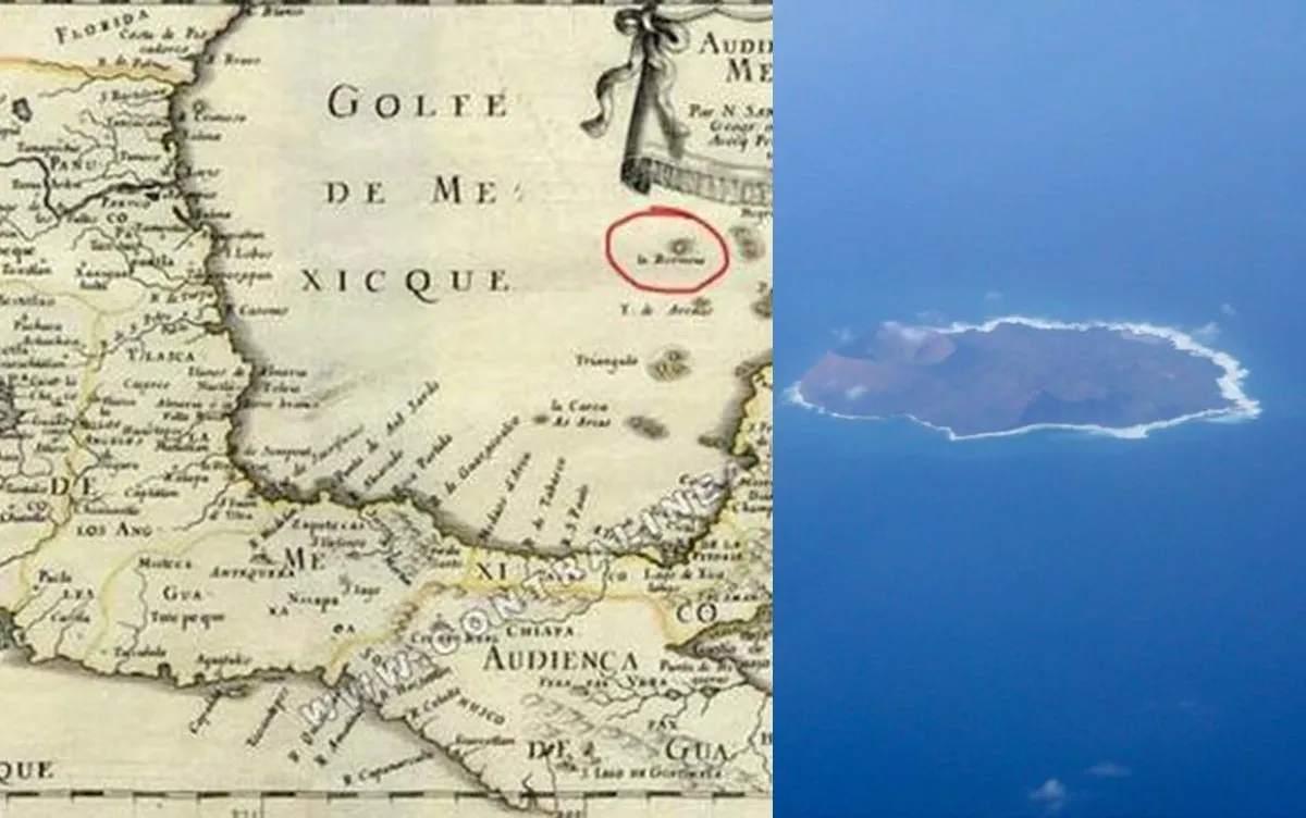
 documents containing very precise descriptions of Bermeja’s existence. On this basis we firmly believe that the island did exist, but in another location.” Well, now, that puts a whole new spin on an otherwise totally confusing situation. Maybe, we should just leave well enough alone and say, “Now you see it, now you don’t.” Highly unlikely.

